 |
|
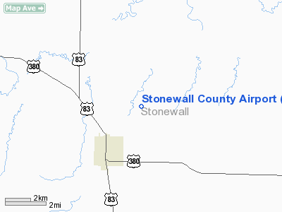
Location & QuickFacts
| FAA Information Effective: | 2008-09-25 |
| Airport Identifier: | T60 |
| Airport Status: | Operational |
| Longitude/Latitude: | 100-11-51.3760W/33-10-20.3470N
-100.197604/33.172319 (Estimated) |
| Elevation: | 1744 ft / 531.57 m (Estimated) |
| Land: | 80 acres |
| From nearest city: | 1 nautical miles NE of Aspermont, TX |
| Location: | Stonewall County, TX |
| Magnetic Variation: | 08E (1986) |
Owner & Manager
| Ownership: | Publicly owned |
| Owner: | Stonewall County |
| Address: | Po Box 366
Aspermont, TX 79502 |
| Phone number: | 940-989-3393 |
| Manager: | Bobby Mc Gough
COUNTY JUDGE. |
| Address: | Po Box 366
Aspermont, TX 79502 |
| Phone number: | 940-989-3393
EMERGENCY PHONE: 940-989-3333. |
Airport Operations and Facilities
| Airport Use: | Open to public |
| Wind indicator: | Yes |
| Segmented Circle: | Yes |
| Control Tower: | No |
| Lighting Schedule: | DUSK-DAWN |
| Beacon Color: | Clear-Green (lighted land airport) |
| Sectional chart: | Dallas-ft Worth |
| Region: | ASW - Southwest |
| Boundary ARTCC: | ZFW - Fort Worth |
| Tie-in FSS: | FTW - Fort Worth |
| FSS on Airport: | No |
| FSS Phone: | 817-541-3474 |
| FSS Toll Free: | 1-800-WX-BRIEF |
| NOTAMs Facility: | FTW (NOTAM-d service avaliable) |
| Federal Agreements: | NGY |
Airport Communications
Airport Services
Runway Information
Runway 17/35
| Dimension: | 4000 x 60 ft / 1219.2 x 18.3 m |
| Surface: | ASPH, Fair Condition |
| Weight Limit: | Single wheel: 12500 lbs. |
| Edge Lights: | Medium |
| |
Runway 17 |
Runway 35 |
| Traffic Pattern: | Left | Left |
| Markings: | Non-precision instrument, Fair Condition | Non-precision instrument, Fair Condition |
| Obstruction: | 10 ft trees, 415.0 ft from runway, 21:1 slope to clear | 20 ft pline, 895.0 ft from runway, 34:1 slope to clear |
|
Radio Navigation Aids
| ID |
Type |
Name |
Ch |
Freq |
Var |
Dist |
| AKL | NDB | Haskell | | 407.00 | 08E | 24.1 nm |
| TMV | NDB | Stamford | | 290.00 | 08E | 29.7 nm |
| SWW | NDB | Sweetwater | | 275.00 | 08E | 44.8 nm |
| SDR | NDB | Snyder | | 359.00 | 08E | 47.2 nm |
| DYS | TACAN | Dyess | 063X | | 08E | 48.5 nm |
| GTH | VORTAC | Guthrie | 092X | 114.50 | 10E | 37.1 nm |
| ABI | VORTAC | Abilene | 084X | 113.70 | 10E | 44.8 nm |
Remarks
- WILDLIFE ON & INVOF ARPT.
- ACCESS KEY TO ARPT AT COUNTY COURTHOUSE.
- RY 17/35 AND PARALLEL TWY HAS 1-2 INCH LONGITUDINAL AND TRANSVERSE CRACKS.
- AGRICULTURAL ACTIVITY MAY-SEP AT ARPT.
Images and information placed above are from
http://www.airport-data.com/airport/T60/
We thank them for the data!
| General Info
|
| Country |
United States
|
| State |
TEXAS
|
| FAA ID |
T60
|
| Latitude |
33-10-20.347N
|
| Longitude |
100-11-51.376W
|
| Elevation |
1744 feet
|
| Near City |
ASPERMONT
|
We don't guarantee the information is fresh and accurate. The data may
be wrong or outdated.
For more up-to-date information please refer to other sources.
|
|


