 |
|
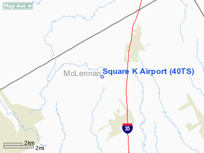
Location & QuickFacts
| FAA Information Effective: | 2008-09-25 |
| Airport Identifier: | 40TS |
| Airport Status: | Operational |
| Longitude/Latitude: | 097-07-56.0130W/31-46-20.5810N
-97.132226/31.772384 (Estimated) |
| Elevation: | 590 ft / 179.83 m (Estimated) |
| Land: | 0 acres |
| From nearest city: | 2 nautical miles SW of West, TX |
| Location: | Mc Lennan County, TX |
| Magnetic Variation: | 06E (1990) |
Owner & Manager
| Ownership: | Privately owned |
| Owner: | John J Kostecka |
| Address: | Route 1 Box 40
West, TX 76691 |
| Phone number: | 817-826-3097 |
| Manager: | John J Kostecka |
| Address: | Route 1 Box 40
West, TX 76691 |
| Phone number: | 817-826-3097 |
Airport Operations and Facilities
| Airport Use: | Private |
| Segmented Circle: | No |
| Control Tower: | No |
| Sectional chart: | San Antonio |
| Region: | ASW - Southwest |
| Boundary ARTCC: | ZFW - Fort Worth |
| Tie-in FSS: | FTW - Fort Worth |
| FSS on Airport: | No |
| FSS Phone: | 817-541-3474 |
| FSS Toll Free: | 1-800-WX-BRIEF |
Runway Information
Runway 15/33
| Dimension: | 2400 x 100 ft / 731.5 x 30.5 m |
| Surface: | TURF, |
| |
Runway 15 |
Runway 33 |
| Traffic Pattern: | Left | Left |
|
Radio Navigation Aids
| ID |
Type |
Name |
Ch |
Freq |
Var |
Dist |
| ROB | NDB | Robinson | | 400.00 | 07E | 16.5 nm |
| LXY | NDB | Mexia | | 329.00 | 07E | 32.7 nm |
| CGQ | NDB | Powell | | 344.00 | 06E | 40.0 nm |
| CRS | NDB | Corsicana | | 396.00 | 06E | 40.6 nm |
| PYF | NDB | Pyramid | | 418.00 | 06E | 48.1 nm |
| HLR | NDB | Hood | | 347.00 | 07E | 48.8 nm |
| XQH | NDB | Cedar Hill | | 353.00 | 08E | 49.9 nm |
| GNL | VOR/DME | Groesbeck | 025X | 108.80 | 05E | 32.0 nm |
| TPL | VOR/DME | Temple | 041X | 110.40 | 09E | 37.0 nm |
| ACT | VORTAC | Waco | 100X | 115.30 | 09E | 9.6 nm |
| JEN | VORTAC | Glen Rose | 097X | 115.00 | 06E | 44.6 nm |
Images and information placed above are from
http://www.airport-data.com/airport/40TS/
We thank them for the data!
| General Info
|
| Country |
United States
|
| State |
TEXAS
|
| FAA ID |
40TS
|
| Latitude |
31-46-20.581N
|
| Longitude |
097-07-56.013W
|
| Elevation |
590 feet
|
| Near City |
WEST
|
We don't guarantee the information is fresh and accurate. The data may
be wrong or outdated.
For more up-to-date information please refer to other sources.
|
|


