 |
|
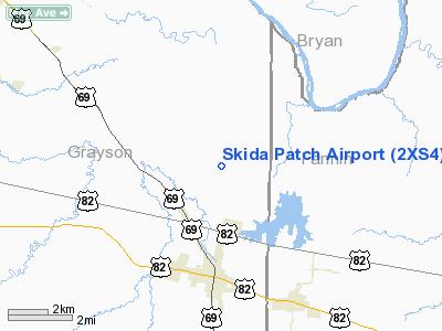
Location & QuickFacts
| FAA Information Effective: | 2008-09-25 |
| Airport Identifier: | 2XS4 |
| Airport Status: | Operational |
| Longitude/Latitude: | 096-24-23.0000W/33-39-41.0000N
-96.406389/33.661389 (Estimated) |
| Elevation: | 665 ft / 202.69 m (Estimated) |
| Land: | 0 acres |
| From nearest city: | 3 nautical miles N of Bells, TX |
| Location: | Grayson County, TX |
| Magnetic Variation: | () |
Owner & Manager
| Ownership: | Privately owned |
| Owner: | George A. Haskell |
| Address: | 5527 Dugan Chapel Road
Bells, TX 75414 |
| Phone number: | 903-965-7961 |
| Manager: | George A. Haskell |
| Address: | 5527 Dugan Chapel Road
Bells, TX 75414 |
| Phone number: | 903-965-7961 |
Airport Operations and Facilities
| Airport Use: | Private |
| Wind indicator: | Yes |
| Control Tower: | No |
| Sectional chart: | Dallas-ft Worth |
| Region: | ASW - Southwest |
| Boundary ARTCC: | ZFW - Fort Worth |
| Tie-in FSS: | FTW - Fort Worth |
| FSS Phone: | 817-541-3474 |
| FSS Toll Free: | 1-800-WX-BRIEF |
Runway Information
Runway 01/19
| Dimension: | 1200 x 45 ft / 365.8 x 13.7 m |
| Surface: | TURF, |
| |
Runway 01 |
Runway 19 |
| Traffic Pattern: | Left | Left |
|
Radio Navigation Aids
| ID |
Type |
Name |
Ch |
Freq |
Var |
Dist |
| HJM | NDB | Rayburn | | 415.00 | 06E | 11.9 nm |
| DNI | NDB | Denison | | 341.00 | 06E | 16.4 nm |
| DUA | NDB | Durant | | 359.00 | 05E | 16.9 nm |
| MII | NDB | Caddo Mills | | 316.00 | 06E | 38.2 nm |
| GLE | NDB | Gainesville | | 330.00 | 06E | 39.8 nm |
| SYW | NDB | Cash | | 428.00 | 05E | 44.3 nm |
| AUV | NDB | Arbuckle | | 284.00 | 07E | 46.4 nm |
| HHW | NDB | Hugo | | 323.00 | 05E | 48.9 nm |
| AEE | NDB | Antlers | | 391.00 | 05E | 49.3 nm |
| MJF | TACAN | Arvilla | 033X | | 05E | 39.7 nm |
| URH | VOR/DME | Texoma | 090X | 114.30 | 05E | 17.0 nm |
| PRX | VOR/DME | Paris | 083X | 113.60 | 07E | 48.5 nm |
| BYP | VORTAC | Bonham | 093X | 114.60 | 06E | 11.4 nm |
Images and information placed above are from
http://www.airport-data.com/airport/2XS4/
We thank them for the data!
| General Info
|
| Country |
United States
|
| State |
TEXAS
|
| FAA ID |
2XS4
|
| Latitude |
32-23-00.200N
|
| Longitude |
099-30-32.780W
|
| Elevation |
1995 feet
|
| Near City |
CLYDE
|
We don't guarantee the information is fresh and accurate. The data may
be wrong or outdated.
For more up-to-date information please refer to other sources.
|
|


