 |
|
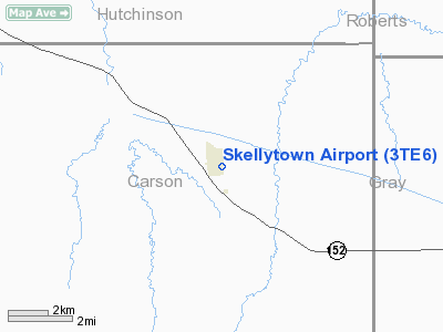
Location & QuickFacts
| FAA Information Effective: | 2008-09-25 |
| Airport Identifier: | 3TE6 |
| Airport Status: | Operational |
| Longitude/Latitude: | 101-10-08.5650W/35-34-12.1590N
-101.169046/35.570044 (Estimated) |
| Elevation: | 3280 ft / 999.74 m (Estimated) |
| Land: | 10 acres |
| From nearest city: | 0 nautical miles E of Skellytown, TX |
| Location: | Carson County, TX |
| Magnetic Variation: | 09E (1985) |
Owner & Manager
| Ownership: | Privately owned |
| Owner: | Skellytown American Flyers |
| Address: | 11507 Dakota Trail
Amarillo, TX 79118 |
| Phone number: | 806-622-1652 |
| Manager: | W.e. Mckinney |
| Address: | 11507 Dakota Trail
Amarillo, TX 79118 |
| Phone number: | 806-622-1652 |
Airport Operations and Facilities
| Airport Use: | Private |
| Wind indicator: | Yes |
| Segmented Circle: | No |
| Control Tower: | No |
| Landing fee charge: | No |
| Sectional chart: | Dallas-ft Worth |
| Region: | ASW - Southwest |
| Traffic Pattern Alt: | 800 ft |
| Boundary ARTCC: | ZAB - Albuquerque |
| Tie-in FSS: | FTW - Fort Worth |
| FSS on Airport: | No |
| FSS Phone: | 817-541-3474 |
| FSS Toll Free: | 1-800-WX-BRIEF |
Airport Services
| Airframe Repair: | NONE |
| Power Plant Repair: | NONE |
Runway Information
Runway 17/35
| Dimension: | 2100 x 80 ft / 640.1 x 24.4 m
VERY ROUGH. |
| Surface: | DIRT, Poor Condition |
| |
Runway 17 |
Runway 35 |
| Traffic Pattern: | Left | Left |
| Obstruction: | 4 ft fence, 56 ft left of centerline | 7 ft fence, 15.0 ft from runway, 2:1 slope to clear |
|
Radio Navigation Aids
| ID |
Type |
Name |
Ch |
Freq |
Var |
Dist |
| PPA | NDB | Pampa | | 368.00 | 09E | 9.0 nm |
| AM | NDB | Pande | | 251.00 | 09E | 40.3 nm |
| HHF | NDB | Hemphill County | | 400.00 | 08E | 42.0 nm |
| DUX | NDB | Durrett | | 414.00 | 09E | 44.8 nm |
| BGD | VORTAC | Borger | 023X | 108.60 | 11E | 17.6 nm |
| PNH | VORTAC | Panhandle | 113X | 116.60 | 08E | 32.9 nm |
Remarks
- RY 17 +45 FT PLINE-M 355 FT FROM THLD ACROSS APCH.
- MOBIL HOMES NW SIDE RY, EAST PROPERTY LINE FENCE & HGR SE END RY VIOLATE PRIM SFC.
Images and information placed above are from
http://www.airport-data.com/airport/3TE6/
We thank them for the data!
| General Info
|
| Country |
United States
|
| State |
TEXAS
|
| FAA ID |
3TE6
|
| Latitude |
35-34-12.159N
|
| Longitude |
101-10-08.565W
|
| Elevation |
3280 feet
|
| Near City |
SKELLYTOWN
|
We don't guarantee the information is fresh and accurate. The data may
be wrong or outdated.
For more up-to-date information please refer to other sources.
|
|


