 |
|
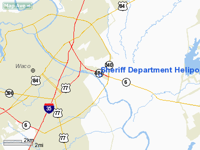
Sheriff Department Heliport |
Location & QuickFacts
| FAA Information Effective: | 2008-09-25 |
| Airport Identifier: | TA04 |
| Airport Status: | Operational |
| Longitude/Latitude: | 097-04-43.9980W/31-32-53.6000N
-97.078888/31.548222 (Estimated) |
| Elevation: | 385 ft / 117.35 m (Estimated) |
| Land: | 13 acres |
| From nearest city: | 0 nautical miles N of Waco, TX |
| Location: | Mc Lennan County, TX |
| Magnetic Variation: | 07E (1985) |
Owner & Manager
| Ownership: | Publicly owned |
| Owner: | Mc Lellan County Sheriff Dept |
| Address: | 130 County Records Bldg
Waco, TX 76701 |
| Phone number: | 817-757-5000 |
| Manager: | Dan Weyenberg |
| Address: | 219 No. 6th Street
Waco, TX 76701 |
| Phone number: | 817-757-5111 |
Airport Operations and Facilities
| Airport Use: | Private |
| Wind indicator: | Yes |
| Segmented Circle: | No |
| Control Tower: | No |
| Sectional chart: | San Antonio |
| Region: | ASW - Southwest |
| Boundary ARTCC: | ZFW - Fort Worth |
| Tie-in FSS: | FTW - Fort Worth |
| FSS Phone: | 817-541-3474 |
| FSS Toll Free: | 1-800-WX-BRIEF |
Runway Information
Helipad H1
| Dimension: | 50 x 50 ft / 15.2 x 15.2 m |
| Surface: | TURF, |
| |
Runway H1 |
Runway |
| Traffic Pattern: | Left | Left |
|
Radio Navigation Aids
| ID |
Type |
Name |
Ch |
Freq |
Var |
Dist |
| ROB | NDB | Robinson | | 400.00 | 07E | 2.7 nm |
| LXY | NDB | Mexia | | 329.00 | 07E | 29.5 nm |
| HLR | NDB | Hood | | 347.00 | 07E | 41.1 nm |
| IL | NDB | Iresh | | 278.00 | 07E | 45.1 nm |
| CRS | NDB | Corsicana | | 396.00 | 06E | 45.3 nm |
| CGQ | NDB | Powell | | 344.00 | 06E | 45.5 nm |
| GR | NDB | Starn | | 323.00 | 07E | 47.0 nm |
| PYF | NDB | Pyramid | | 418.00 | 06E | 48.9 nm |
| TPL | VOR/DME | Temple | 041X | 110.40 | 09E | 27.0 nm |
| GNL | VOR/DME | Groesbeck | 025X | 108.80 | 05E | 27.2 nm |
| GRK | VOR/DME | Gray | 055X | 111.80 | 07E | 48.8 nm |
| ACT | VORTAC | Waco | 100X | 115.30 | 09E | 11.9 nm |
Remarks
- PROVIDED HELICOPTER OPERATIONS CONDUCTED DAYTIME VFR WEATHER CONDITIONS; REMAINS PRIVATE-USE; AND A WIND INDICATOR IS PLACED NEAR HELIPORT BUT AWAY FROM APCH/DEP ROUTES.
Images and information placed above are from
http://www.airport-data.com/airport/TA04/
We thank them for the data!
| General Info
|
| Country |
United States
|
| State |
TEXAS
|
| FAA ID |
TA04
|
| Latitude |
31-32-53.600N
|
| Longitude |
097-04-43.998W
|
| Elevation |
385 feet
|
| Near City |
WACO
|
We don't guarantee the information is fresh and accurate. The data may
be wrong or outdated.
For more up-to-date information please refer to other sources.
|
|


