 |
|
Location & QuickFacts
| FAA Information Effective: | 2008-09-25 |
| Airport Identifier: | 78TE |
| Airport Status: | Operational |
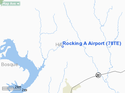
| Longitude/Latitude: | 097-19-52.0400W/32-01-13.5500N
-97.331122/32.020431 (Estimated) |
| Elevation: | 635 ft / 193.55 m (Estimated) |
| Land: | 17 acres |
| From nearest city: | 5 nautical miles N of Whitney, TX |
| Location: | Hill County, TX |
| Magnetic Variation: | 06E (2000) |
Owner & Manager
| Ownership: | Privately owned |
| Owner: | Jack Allmon |
| Address: | 01721 Highland Drive Wb29
Whitney, TX 76692 |
| Phone number: | 254-694-9692 |
| Manager: | Jack Allmon |
| Address: | 01721 Highland Dr Wb29
Whitney, TX 76692 |
| Phone number: | 254-694-9692 |
Airport Operations and Facilities
| Airport Use: | Private |
| Wind indicator: | Yes |
| Segmented Circle: | No |
| Control Tower: | No |
| Sectional chart: | Dallas-ft Worth |
| Region: | ASW - Southwest |
| Boundary ARTCC: | ZFW - Fort Worth |
| Tie-in FSS: | FTW - Fort Worth |
| FSS Phone: | 817-541-3474 |
| FSS Toll Free: | 1-800-WX-BRIEF |
Runway Information
Runway 06/24
| Dimension: | 1000 x 40 ft / 304.8 x 12.2 m |
| Surface: | TURF, Good Condition |
| |
Runway 06 |
Runway 24 |
| Traffic Pattern: | Left | Left |
| Obstruction: | 4 ft fence, 20.0 ft from runway | 4 ft fence, 20.0 ft from runway |
|
Runway 12/30
| Dimension: | 1350 x 40 ft / 411.5 x 12.2 m |
| Surface: | TURF, Good Condition |
| |
Runway 12 |
Runway 30 |
| Traffic Pattern: | Left | Left |
| Obstruction: | 4 ft fence, 20.0 ft from runway | 4 ft fence, 20.0 ft from runway |
|
Radio Navigation Aids
| ID |
Type |
Name |
Ch |
Freq |
Var |
Dist |
| ROB | NDB | Robinson | | 400.00 | 07E | 33.8 nm |
| XQH | NDB | Cedar Hill | | 353.00 | 08E | 38.8 nm |
| LNC | NDB | Lancaster | | 239.00 | 06E | 45.6 nm |
| RBD | NDB | Redbird | | 287.00 | 06E | 45.9 nm |
| CGQ | NDB | Powell | | 344.00 | 06E | 46.1 nm |
| LXY | NDB | Mexia | | 329.00 | 07E | 47.7 nm |
| CRS | NDB | Corsicana | | 396.00 | 06E | 47.7 nm |
| MNZ | NDB | Hamilton | | 251.00 | 07E | 48.1 nm |
| NFW | TACAN | Nas Jrb Fort Worth | 024X | | 07E | 45.5 nm |
| GNL | VOR/DME | Groesbeck | 025X | 108.80 | 05E | 47.9 nm |
| TPL | VOR/DME | Temple | 041X | 110.40 | 09E | 49.0 nm |
| ACT | VORTAC | Waco | 100X | 115.30 | 09E | 21.8 nm |
| JEN | VORTAC | Glen Rose | 097X | 115.00 | 06E | 29.1 nm |
| FTW | VOT | Fort Worth Meacham | | 108.20 | | 47.9 nm |
Images and information placed above are from
http://www.airport-data.com/airport/78TE/
We thank them for the data!
| General Info
|
| Country |
United States
|
| State |
TEXAS
|
| FAA ID |
78TE
|
| Latitude |
32-01-13.550N
|
| Longitude |
097-19-52.040W
|
| Elevation |
635 feet
|
| Near City |
WHITNEY
|
We don't guarantee the information is fresh and accurate. The data may
be wrong or outdated.
For more up-to-date information please refer to other sources.
|
|


