 |
|
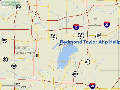
Redmond Taylor Ahp Heliport |
Location & QuickFacts
| FAA Information Effective: | 2008-09-25 |
| Airport Identifier: | TX18 |
| Airport Status: | Operational |
| Longitude/Latitude: | 096-58-20.1000W/32-44-01.8000N
-96.972250/32.733833 (Estimated) |
| Elevation: | 480 ft / 146.30 m (Estimated) |
| Land: | 108 acres |
| From nearest city: | 10 nautical miles SW of Dallas, TX |
| Location: | Dallas County, TX |
| Magnetic Variation: | 06E (1995) |
Owner & Manager
| Ownership: | Privately owned |
| Owner: | Texas Army National Guard |
| Address: | 1009 Lakecrest Dr
Grand Prairie, TX 75051 |
| Phone number: | 972-264-6418 |
| Address: |
|
Airport Operations and Facilities
| Airport Use: | Private |
| Wind indicator: | Yes |
| Segmented Circle: | No |
| Control Tower: | No |
| Lighting Schedule: | PHONE REQ
FOR PERIMETER LGTS CALL 972-264-6418. |
| Sectional chart: | Dallas-ft Worth |
| Region: | ASW - Southwest |
| Boundary ARTCC: | ZFW - Fort Worth |
| Tie-in FSS: | FTW - Fort Worth |
| FSS Phone: | 817-541-3474 |
| FSS Toll Free: | 1-800-WX-BRIEF |
Airport Communications
Runway Information
Helipad H1
| Dimension: | 450 x 75 ft / 137.2 x 22.9 m |
| Surface: | ASPH, |
| |
Runway H1 |
Runway |
| Traffic Pattern: | Left | Left |
|
Radio Navigation Aids
| ID |
Type |
Name |
Ch |
Freq |
Var |
Dist |
| RBD | NDB | Redbird | | 287.00 | 06E | 6.2 nm |
| XQH | NDB | Cedar Hill | | 353.00 | 08E | 8.6 nm |
| LNC | NDB | Lancaster | | 239.00 | 06E | 15.8 nm |
| JUG | NDB | Jecca | | 388.00 | 06E | 22.6 nm |
| PQF | NDB | Mesquite | | 248.00 | 06E | 22.9 nm |
| AVZ | NDB | Travis | | 260.00 | 06E | 36.6 nm |
| MII | NDB | Caddo Mills | | 316.00 | 06E | 40.9 nm |
| SYW | NDB | Cash | | 428.00 | 05E | 48.1 nm |
| CGQ | NDB | Powell | | 344.00 | 06E | 48.8 nm |
| NFW | TACAN | Nas Jrb Fort Worth | 024X | | 07E | 23.7 nm |
| TTT | VOR/DME | Maverick | 078X | 113.10 | 06E | 8.8 nm |
| CVE | VOR/DME | Cowboy | 109X | 116.20 | 06E | 10.0 nm |
| FUZ | VORTAC | Ranger | 104X | 115.70 | 06E | 14.0 nm |
| DAL | VOT | Dallas Love Field | | 113.30 | | 9.1 nm |
| FTW | VOT | Fort Worth Meacham | | 108.20 | | 20.2 nm |
Remarks
- ALL TFC TO THE WEST 1500 FT.
- 8 FT FENCE NORTH & EAST OF HELIPAD.
- PPR CALL C972-264-6418.
- ALL ACFT NOTIFY NG OPS 10 MIN PRIOR TO ARR.
Images and information placed above are from
http://www.airport-data.com/airport/TX18/
We thank them for the data!
| General Info
|
| Country |
United States
|
| State |
TEXAS
|
| FAA ID |
TX18
|
| Latitude |
32-44-01.800N
|
| Longitude |
096-58-20.100W
|
| Elevation |
480 feet
|
| Near City |
DALLAS
|
We don't guarantee the information is fresh and accurate. The data may
be wrong or outdated.
For more up-to-date information please refer to other sources.
|
|


