 |
|
Location & QuickFacts
| FAA Information Effective: | 2008-09-25 |
| Airport Identifier: | 78TA |
| Airport Status: | Operational |
| Longitude/Latitude: | 098-48-01.0900W/29-03-40.8790N
-98.800303/29.061355 (Estimated) |
| Elevation: | 560 ft / 170.69 m (Estimated) |
| Land: | 143 acres |
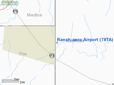
| From nearest city: | 4 nautical miles E of Bigfoot, TX |
| Location: | Atascosa County, TX |
| Magnetic Variation: | 07E (1985) |
Owner & Manager
| Ownership: | Privately owned |
| Owner: | Tom Gould |
| Address: | Po Box 377
Tilden, TX 78072 |
| Phone number: | 210-373-4448 |
| Manager: | Tom Gould |
| Address: | Po Box 377
Tilden, TX 78072 |
| Phone number: | 210-373-4448 |
Airport Operations and Facilities
| Airport Use: | Private |
| Wind indicator: | Yes |
| Segmented Circle: | No |
| Control Tower: | No |
| Lighting Schedule: | DUSK-DAWN
FOR STOBE BCN CALL 210-663-3959 OR 210-373-4448. |
| Landing fee charge: | No |
| Sectional chart: | San Antonio |
| Region: | ASW - Southwest |
| Boundary ARTCC: | ZHU - Houston |
| Tie-in FSS: | SJT - San Angelo |
| FSS on Airport: | No |
| FSS Toll Free: | 1-800-WX-BRIEF |
Airport Communications
Runway Information
Runway 03/21
| Dimension: | 3000 x 100 ft / 914.4 x 30.5 m |
| Surface: | TURF, |
| Edge Lights: | Medium |
| |
Runway 03 |
Runway 21 |
| Traffic Pattern: | Left | Right |
| Displaced threshold: | 400.00 ft | 0.00 ft |
|
Radio Navigation Aids
| ID |
Type |
Name |
Ch |
Freq |
Var |
Dist |
| HHH | NDB | Devine | | 359.00 | 07E | 8.6 nm |
| PEZ | NDB | Pleasanton | | 275.00 | 07E | 16.1 nm |
| CVB | NDB | Castroville | | 338.00 | 08E | 17.3 nm |
| HMA | NDB | Hondo | | 329.00 | 08E | 27.1 nm |
| UVA | NDB | Uvalde | | 281.00 | 07E | 49.1 nm |
| KSY | TACAN | Kelly | 057X | | 07E | 22.9 nm |
| DHK | TACAN | Randolph | 036X | | 09E | 40.0 nm |
| SSF | VOR | Stinson | | 108.40 | 09E | 22.2 nm |
| HDO | VOR/DME | Hondo | 31X | 109.40 | 08E | 26.3 nm |
| RND | VORTAC | Randolph | 70X | 112.30 | 09E | 38.6 nm |
| SAT | VORTAC | San Antonio | 115X | 116.80 | 08E | 39.3 nm |
| COT | VORTAC | Cotulla | 105X | 115.80 | 09E | 39.7 nm |
| THX | VORTAC | Three Rivers | 051X | 111.40 | 08E | 47.9 nm |
| SAT | VOT | San Antonio Intl | | 110.40 | | 33.3 nm |
Remarks
- CONDITIONAL - PROVIDED RWY LANDING THRESHOLDS ARE LOCATED TO PROVIDE CLEAR 20:1 APPROACH AREAS.
Images and information placed above are from
http://www.airport-data.com/airport/78TA/
We thank them for the data!
| General Info
|
| Country |
United States
|
| State |
TEXAS
|
| FAA ID |
78TA
|
| Latitude |
29-03-40.879N
|
| Longitude |
098-48-01.090W
|
| Elevation |
560 feet
|
| Near City |
BIGFOOT
|
We don't guarantee the information is fresh and accurate. The data may
be wrong or outdated.
For more up-to-date information please refer to other sources.
|
|


