 |
|
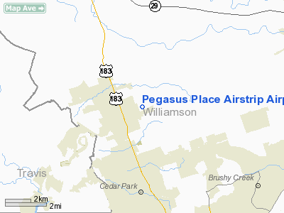
Pegasus Place Airstrip Airport |
Location & QuickFacts
| FAA Information Effective: | 2008-09-25 |
| Airport Identifier: | 8XS3 |
| Airport Status: | Operational |
| Longitude/Latitude: | 097-49-46.0440W/30-34-00.7020N
-97.829457/30.566862 (Estimated) |
| Elevation: | 965 ft / 294.13 m (Estimated) |
| Land: | 5 acres |
| From nearest city: | 2 nautical miles SE of Leander, TX |
| Location: | Williamson County, TX |
| Magnetic Variation: | 07E (1985) |
Owner & Manager
| Ownership: | Privately owned |
| Owner: | Isaac F. Wiley |
| Address: | P.o. Box 318
Leander, TX 78646-0318 |
| Phone number: | 512-259-1563 |
| Manager: | Isaac F. Wiley |
| Address: | P.o. Box 318
Leander, TX 78646-0318 |
| Phone number: | 512-259-1563 |
Airport Operations and Facilities
| Airport Use: | Private |
| Wind indicator: | Yes |
| Segmented Circle: | No |
| Control Tower: | No |
| Landing fee charge: | No |
| Sectional chart: | San Antonio |
| Region: | ASW - Southwest |
| Boundary ARTCC: | ZHU - Houston |
| Tie-in FSS: | SJT - San Angelo |
| FSS on Airport: | No |
| FSS Toll Free: | 1-800-WX-BRIEF |
Airport Services
Runway Information
Runway 15/33
| Dimension: | 2700 x 75 ft / 823.0 x 22.9 m |
| Surface: | TURF, |
| |
Runway 15 |
Runway 33 |
| Traffic Pattern: | Right | Left |
| Markings: | Nonstandard, | Nonstandard, |
| Displaced threshold: | 500.00 ft | 500.00 ft |
| Obstruction: | 25 ft pline | 25 ft pline, 60.0 ft from runway |
|
Radio Navigation Aids
| ID |
Type |
Name |
Ch |
Freq |
Var |
Dist |
| GUO | NDB | Georgetown | | 332.00 | 06E | 10.5 nm |
| BMQ | NDB | Burnet | | 341.00 | 07E | 23.5 nm |
| MFS | NDB | Horseshoe Bay Resort | | 403.00 | 07E | 27.5 nm |
| IL | NDB | Iresh | | 278.00 | 07E | 28.2 nm |
| HLR | NDB | Hood | | 347.00 | 07E | 34.3 nm |
| GR | NDB | Starn | | 323.00 | 07E | 36.2 nm |
| GRK | VOR/DME | Gray | 055X | 111.80 | 07E | 28.0 nm |
| TPL | VOR/DME | Temple | 041X | 110.40 | 09E | 43.9 nm |
| CWK | VORTAC | Centex | 075X | 112.80 | 06E | 19.2 nm |
| LZZ | VORTAC | Lampasas | 072X | 112.50 | 08E | 40.5 nm |
Remarks
- PROVIDED RWY 15 IS DISPLACED BY 500' TO PROVIDE 20:1 CLNC OVER 25' AGL PLINE. RWY 33 THR SHOULD BE DISPLACED BY 1075'; VFR ONLY.
Images and information placed above are from
http://www.airport-data.com/airport/8XS3/
We thank them for the data!
| General Info
|
| Country |
United States
|
| State |
TEXAS
|
| FAA ID |
8XS3
|
| Latitude |
30-34-00.702N
|
| Longitude |
097-49-46.044W
|
| Elevation |
965 feet
|
| Near City |
LEANDER
|
We don't guarantee the information is fresh and accurate. The data may
be wrong or outdated.
For more up-to-date information please refer to other sources.
|
|


