 |
|
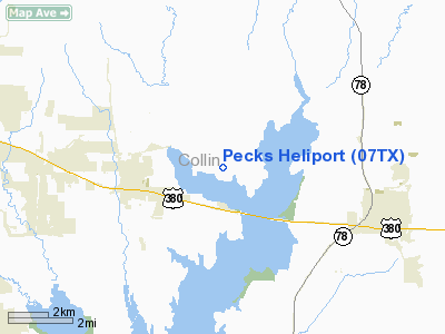
Location & QuickFacts
| FAA Information Effective: | 2008-09-25 |
| Airport Identifier: | 07TX |
| Airport Status: | Operational |
| Longitude/Latitude: | 096-26-52.9460W/33-11-02.4170N
-96.448041/33.184005 (Estimated) |
| Elevation: | 660 ft / 201.17 m (Estimated) |
| Land: | 10 acres |
| From nearest city: | 3 nautical miles NE of Princeton, TX |
| Location: | Collin County, TX |
| Magnetic Variation: | 07E (1985) |
Owner & Manager
| Ownership: | Privately owned |
| Owner: | Dalton L. Peck |
| Address: | Rt 1 Box 136f
Princeton, TX 75407 |
| Phone number: | 214-736-3388 |
| Manager: | Dalton L. Peck |
| Address: | Rt 1 Box 136f
Princeton, TX 75407 |
| Phone number: | 214-231-2255 |
Airport Operations and Facilities
| Airport Use: | Private |
| Wind indicator: | Yes |
| Segmented Circle: | No |
| Control Tower: | No |
| Sectional chart: | Dallas-ft Worth |
| Region: | ASW - Southwest |
| Boundary ARTCC: | ZFW - Fort Worth |
| Tie-in FSS: | FTW - Fort Worth |
| FSS on Airport: | No |
| FSS Phone: | 817-541-3474 |
| FSS Toll Free: | 1-800-WX-BRIEF |
Runway Information
Helipad H1
| Dimension: | 400 x 50 ft / 121.9 x 15.2 m |
| Surface: | TURF, |
| |
Runway H1 |
Runway |
| Traffic Pattern: | Left | Left |
|
Radio Navigation Aids
| ID |
Type |
Name |
Ch |
Freq |
Var |
Dist |
| MII | NDB | Caddo Mills | | 316.00 | 06E | 13.2 nm |
| SYW | NDB | Cash | | 428.00 | 05E | 22.7 nm |
| PQF | NDB | Mesquite | | 248.00 | 06E | 22.9 nm |
| AVZ | NDB | Travis | | 260.00 | 06E | 27.4 nm |
| HJM | NDB | Rayburn | | 415.00 | 06E | 29.2 nm |
| JUG | NDB | Jecca | | 388.00 | 06E | 31.3 nm |
| RBD | NDB | Redbird | | 287.00 | 06E | 37.2 nm |
| LNC | NDB | Lancaster | | 239.00 | 06E | 39.0 nm |
| DNI | NDB | Denison | | 341.00 | 06E | 40.0 nm |
| XQH | NDB | Cedar Hill | | 353.00 | 08E | 44.5 nm |
| DUA | NDB | Durant | | 359.00 | 05E | 45.6 nm |
| GLE | NDB | Gainesville | | 330.00 | 06E | 49.5 nm |
| MJF | TACAN | Arvilla | 033X | | 05E | 20.7 nm |
| CVE | VOR/DME | Cowboy | 109X | 116.20 | 06E | 29.0 nm |
| TTT | VOR/DME | Maverick | 078X | 113.10 | 06E | 35.3 nm |
| SLR | VOR/DME | Sulphur Springs | 027X | 109.00 | 08E | 45.6 nm |
| URH | VOR/DME | Texoma | 090X | 114.30 | 05E | 45.8 nm |
| BYP | VORTAC | Bonham | 093X | 114.60 | 06E | 23.8 nm |
| FUZ | VORTAC | Ranger | 104X | 115.70 | 06E | 40.9 nm |
| DAL | VOT | Dallas Love Field | | 113.30 | | 28.7 nm |
Remarks
- PRVDD DALGT VFR; 50' POWERPOLE 20' NW & METERPOLE 20' S OF HELIPAD ARE REMOVED; GROUND ADJ TO SITE IS GRADED TO A SHALLOWER SLOPE;WIND INDICATOR INSTALLED; AND A FENCE IS INSTALLED TO PRESENT PEDESTRIAN ACCESS TO OPERATIONAL AREA.
Images and information placed above are from
http://www.airport-data.com/airport/07TX/
We thank them for the data!
| General Info
|
| Country |
United States
|
| State |
TEXAS
|
| FAA ID |
07TX
|
| Latitude |
33-11-02.417N
|
| Longitude |
096-26-52.946W
|
| Elevation |
660 feet
|
| Near City |
PRINCETON
|
We don't guarantee the information is fresh and accurate. The data may
be wrong or outdated.
For more up-to-date information please refer to other sources.
|
|


