 |
|
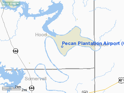
Location & QuickFacts
| FAA Information Effective: | 2008-09-25 |
| Airport Identifier: | 0TX1 |
| Airport Status: | Operational |
| Longitude/Latitude: | 097-40-35.0930W/32-21-14.5080N
-97.676415/32.354030 (Estimated) |
| Elevation: | 710 ft / 216.41 m (Estimated) |
| Land: | 21 acres |
| From nearest city: | 9 nautical miles SE of Granbury, TX |
| Location: | Hood County, TX |
| Magnetic Variation: | 07E (1985) |
Owner & Manager
| Ownership: | Privately owned |
| Owner: | Pecan Plantation Owners Assn |
| Address: | Westover Drive
Granbury, TX 76048 |
| Phone number: | 817-573-2641
EXT 337. |
| Manager: | Michael Bartholomew |
| Address: | Westover Drive
Granbury, TX 76048 |
| Phone number: | 817-573-2641
EXT 337. |
Airport Operations and Facilities
| Airport Use: | Private |
| Wind indicator: | Yes |
| Segmented Circle: | No |
| Control Tower: | No |
| Lighting Schedule: | RDO-CTL
ACTVT MIRL RY 18/36 - 123.05. |
| Landing fee charge: | No |
| Sectional chart: | Dallas-ft Worth |
| Region: | ASW - Southwest |
| Boundary ARTCC: | ZFW - Fort Worth |
| Tie-in FSS: | FTW - Fort Worth |
| FSS on Airport: | No |
| FSS Phone: | 817-541-3474 |
| FSS Toll Free: | 1-800-WX-BRIEF |
Airport Communications
Runway Information
Runway 18/36
| Dimension: | 3500 x 50 ft / 1066.8 x 15.2 m |
| Surface: | ASPH, |
| Edge Lights: | Medium |
| |
Runway 18 |
Runway 36 |
| Traffic Pattern: | Left | Left |
| Markings: | Basic, | Basic, |
| Obstruction: | , 50:1 slope to clear | 30 ft trees, 400.0 ft from runway, 10:1 slope to clear |
|
Radio Navigation Aids
| ID |
Type |
Name |
Ch |
Freq |
Var |
Dist |
| MWL | NDB | Mineral Wells | | 266.00 | 06E | 32.3 nm |
| XQH | NDB | Cedar Hill | | 353.00 | 08E | 38.3 nm |
| RBD | NDB | Redbird | | 287.00 | 06E | 45.2 nm |
| NFW | TACAN | Nas Jrb Fort Worth | 024X | | 07E | 27.8 nm |
| TTT | VOR/DME | Maverick | 078X | 113.10 | 06E | 44.7 nm |
| JEN | VORTAC | Glen Rose | 097X | 115.00 | 06E | 15.5 nm |
| MQP | VORTAC | Millsap | 124X | 117.70 | 09E | 27.7 nm |
| FUZ | VORTAC | Ranger | 104X | 115.70 | 06E | 40.9 nm |
| ACT | VORTAC | Waco | 100X | 115.30 | 09E | 46.5 nm |
| FTW | VOT | Fort Worth Meacham | | 108.20 | | 32.2 nm |
Remarks
Images and information placed above are from
http://www.airport-data.com/airport/0TX1/
We thank them for the data!
| General Info
|
| Country |
United States
|
| State |
TEXAS
|
| FAA ID |
0TX1
|
| Latitude |
32-21-14.508N
|
| Longitude |
097-40-35.093W
|
| Elevation |
710 feet
|
| Near City |
GRANBURY
|
We don't guarantee the information is fresh and accurate. The data may
be wrong or outdated.
For more up-to-date information please refer to other sources.
|
|


