 |
|
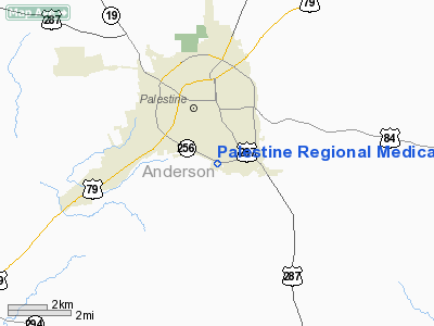
Palestine Regional Medical Center Heliport |
Location & QuickFacts
| FAA Information Effective: | 2008-09-25 |
| Airport Identifier: | 4TS3 |
| Airport Status: | Operational |
| Longitude/Latitude: | 095-37-33.6000W/31-43-58.0400N
-95.626000/31.732789 (Estimated) |
| Elevation: | 570 ft / 173.74 m (Estimated) |
| Land: | 0 acres |
| From nearest city: | 2 nautical miles S of Palestine, TX |
| Location: | Anderson County, TX |
| Magnetic Variation: | () |
Owner & Manager
| Ownership: | Privately owned |
| Owner: | Palestine Principle Heathcare Ltd
PALESTINE PRINCIPLE HEATHCARE LTD PARTNERSHIP. |
| Address: | 2900 S. Loop 256
Palestine, TX 75801 |
| Phone number: | 903-731-1000 |
| Manager: | Tim Flusche
CEO. |
| Address: | 2900 S. Loop 256
Palestine, TX 75801 |
| Phone number: | 903-731-1184 |
Airport Operations and Facilities
| Airport Use: | Private |
| Wind indicator: | Yes |
| Control Tower: | No |
| Lighting Schedule: | DUSK-DAWN |
| Sectional chart: | El Paso |
| Region: | ASW - Southwest |
| Boundary ARTCC: | ZFW - Fort Worth |
| Tie-in FSS: | FTW - Fort Worth |
| FSS Phone: | 817-541-3474 |
| FSS Toll Free: | 1-800-WX-BRIEF |
Runway Information
Helipad H1
| Dimension: | 60 x 60 ft / 18.3 x 18.3 m |
| Surface: | CONC, |
| |
Runway H1 |
Runway |
| Traffic Pattern: | Left | Left |
|
Radio Navigation Aids
| ID |
Type |
Name |
Ch |
Freq |
Var |
Dist |
| PSN | NDB | Palestine | | 375.00 | 04E | 4.8 nm |
| JSO | NDB | Cherokee County | | 263.00 | 05E | 22.5 nm |
| LIQ | NDB | Lochridge Ranch | | 335.00 | 09E | 23.6 nm |
| CSZ | NDB | Crossroads | | 215.00 | 08E | 26.1 nm |
| AHX | NDB | Athens | | 269.00 | 06E | 27.7 nm |
| PYF | NDB | Pyramid | | 418.00 | 06E | 30.2 nm |
| TY | NDB | Tyler | | 320.00 | 06E | 41.8 nm |
| CRS | NDB | Corsicana | | 396.00 | 06E | 43.1 nm |
| CGQ | NDB | Powell | | 344.00 | 06E | 45.5 nm |
| LXY | NDB | Mexia | | 329.00 | 07E | 45.7 nm |
| GXD | NDB | Nacogdoches | | 391.00 | 05E | 47.4 nm |
| HNO | NDB | Henderson | | 371.00 | 06E | 47.6 nm |
| OC | NDB | Nados | | 253.00 | 05E | 48.7 nm |
| FZT | VOR/DME | Frankston | 051X | 111.40 | 06E | 21.1 nm |
| TYR | VOR/DME | Tyler | 089X | 114.20 | 06E | 39.1 nm |
| GNL | VOR/DME | Groesbeck | 025X | 108.80 | 05E | 48.1 nm |
| LOA | VORTAC | Leona | 045X | 110.80 | 08E | 40.6 nm |
| CQY | VORTAC | Cedar Creek | 095X | 114.80 | 06E | 40.7 nm |
Remarks
- 360 FT RADIO TOWER ONE-HALF NM NE OF PAD & 60 FT BLDG ONE-TENTH NM NE OF PAD.
- PRVDD BALLS ARE ADDED TO THE ELECTRICAL WIRES AROUND THE SITE.
Images and information placed above are from
http://www.airport-data.com/airport/4TS3/
We thank them for the data!
| General Info
|
| Country |
United States
|
| State |
TEXAS
|
| FAA ID |
4TS3
|
| Latitude |
29-41-09.830N
|
| Longitude |
095-27-23.787W
|
| Elevation |
50 feet
|
| Near City |
HOUSTON
|
We don't guarantee the information is fresh and accurate. The data may
be wrong or outdated.
For more up-to-date information please refer to other sources.
|
|


