 |
|
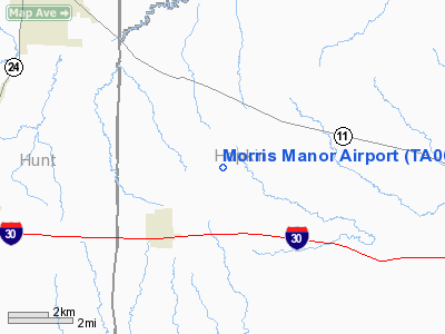
Location & QuickFacts
| FAA Information Effective: | 2008-09-25 |
| Airport Identifier: | TA06 |
| Airport Status: | Operational |
| Longitude/Latitude: | 095-48-20.8650W/33-09-40.4090N
-95.805796/33.161225 (Estimated) |
| Elevation: | 610 ft / 185.93 m (Estimated) |
| Land: | 0 acres |
| From nearest city: | 3 nautical miles NE of Cumby, TX |
| Location: | Hopkins County, TX |
| Magnetic Variation: | 06E (1985) |
Owner & Manager
| Ownership: | Privately owned |
| Owner: | Glenn Morris |
| Address: | 6005 Wrigley Way
Fort Worth, TX 76133 |
| Phone number: | 817-346-8075 |
| Manager: | Glenn Morris |
| Address: | 6005 Wrigley Way
Fort Worth, TX 76133 |
| Phone number: | 817-346-8075 |
Airport Operations and Facilities
| Airport Use: | Private |
| Wind indicator: | Yes |
| Segmented Circle: | No |
| Control Tower: | No |
| Landing fee charge: | Yes |
| Sectional chart: | Dallas-ft Worth |
| Region: | ASW - Southwest |
| Boundary ARTCC: | ZFW - Fort Worth |
| Tie-in FSS: | FTW - Fort Worth |
| FSS on Airport: | No |
| FSS Phone: | 817-541-3474 |
| FSS Toll Free: | 1-800-WX-BRIEF |
Runway Information
Runway 17/35
| Dimension: | 2000 x 50 ft / 609.6 x 15.2 m |
| Surface: | TURF, |
| |
Runway 17 |
Runway 35 |
| Traffic Pattern: | Left | Left |
|
Radio Navigation Aids
| ID |
Type |
Name |
Ch |
Freq |
Var |
Dist |
| SYW | NDB | Cash | | 428.00 | 05E | 17.0 nm |
| MII | NDB | Caddo Mills | | 316.00 | 06E | 23.4 nm |
| AVZ | NDB | Travis | | 260.00 | 06E | 32.9 nm |
| HJM | NDB | Rayburn | | 415.00 | 06E | 33.0 nm |
| PQF | NDB | Mesquite | | 248.00 | 06E | 42.2 nm |
| JUG | NDB | Jecca | | 388.00 | 06E | 47.1 nm |
| TY | NDB | Tyler | | 320.00 | 06E | 47.9 nm |
| ABG | NDB | Ambassador | | 404.00 | 07E | 49.2 nm |
| MJF | TACAN | Arvilla | 033X | | 05E | 14.1 nm |
| SLR | VOR/DME | Sulphur Springs | 027X | 109.00 | 08E | 13.4 nm |
| UIM | VOR/DME | Quitman | 087X | 114.00 | 08E | 27.8 nm |
| PRX | VOR/DME | Paris | 083X | 113.60 | 07E | 29.1 nm |
| BYP | VORTAC | Bonham | 093X | 114.60 | 06E | 31.2 nm |
Images and information placed above are from
http://www.airport-data.com/airport/TA06/
We thank them for the data!
| General Info
|
| Country |
United States
|
| State |
TEXAS
|
| FAA ID |
TA06
|
| Latitude |
33-09-40.409N
|
| Longitude |
095-48-20.865W
|
| Elevation |
610 feet
|
| Near City |
CUMBY
|
We don't guarantee the information is fresh and accurate. The data may
be wrong or outdated.
For more up-to-date information please refer to other sources.
|
|


