 |
|
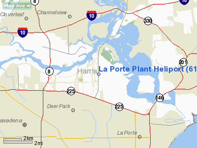
Location & QuickFacts
| FAA Information Effective: | 2008-09-25 |
| Airport Identifier: | 61TS |
| Airport Status: | Operational |
| Longitude/Latitude: | 095-05-20.7500W/29-43-43.8190N
-95.089097/29.728839 (Estimated) |
| Elevation: | 31 ft / 9.45 m (Estimated) |
| Land: | 0 acres |
| From nearest city: | 3 nautical miles SW of Deer Park, TX |
| Location: | Harris County, TX |
| Magnetic Variation: | 06E (1985) |
Owner & Manager
| Ownership: | Privately owned |
| Owner: | Fina Oil & Chemical Co. |
| Address: | P.o. Box 888
Deer Park, TX 77536 |
| Phone number: | 713-476-3700 |
| Manager: | C.j. Monk |
| Address: | 1818 Battleground Road
La Porte, TX 77571 |
| Phone number: | 713-476-3700 |
Airport Operations and Facilities
| Airport Use: | Private |
| Segmented Circle: | No |
| Control Tower: | No |
| Lighting Schedule: | PHONE REQ
PERIMETER LGTS AVBL PHONE 713-476-3700. |
| Sectional chart: | Houston |
| Region: | ASW - Southwest |
| Boundary ARTCC: | ZHU - Houston |
| Tie-in FSS: | CXO - Montgomery County |
| FSS Toll Free: | 1-800-WX-BRIEF
FOR FP FILING CALL CXO FSS 1-800-833-5602. |
Runway Information
Helipad H1
| Dimension: | 53 x 53 ft / 16.2 x 16.2 m |
| Surface: | ASPH, Good Condition |
| |
Runway H1 |
Runway |
| Traffic Pattern: | Left | Left |
| Markings: | Basic, Good Condition | , |
|
Radio Navigation Aids
| ID |
Type |
Name |
Ch |
Freq |
Var |
Dist |
| JPA | NDB | Sanjac | | 347.00 | 05E | 3.8 nm |
| BVP | NDB | Nixin | | 326.00 | 05E | 17.2 nm |
| CBC | NDB | Anahuac | | 413.00 | 05E | 22.4 nm |
| SYG | NDB | Sandy Point | | 402.00 | 05E | 24.0 nm |
| GLS | NDB | Galveston | | 206.00 | 08E | 29.4 nm |
| SGR | NDB | Hull | | 388.00 | 05E | 30.2 nm |
| LYD | NDB | Lakeside | | 249.00 | 05E | 31.2 nm |
| EYQ | NDB | Weiser | | 286.00 | 06E | 31.3 nm |
| DWH | NDB | David Hooks | | 521.00 | 05E | 34.4 nm |
| EFD | TACAN | Ellington | 031X | | 05E | 8.3 nm |
| HUB | VOR/DME | Hobby | 118X | 117.10 | 05E | 10.7 nm |
| MHF | VOR/DME | Trinity | 083X | 113.60 | 07E | 20.9 nm |
| IAH | VORTAC | Humble | 113X | 116.60 | 05E | 19.2 nm |
| VUH | VORTAC | Scholes | 077X | 113.00 | 06E | 29.9 nm |
| DAS | VORTAC | Daisetta | 116X | 116.90 | 05E | 36.1 nm |
| HOU | VOT | Houston Wm P Hobby | | 108.40 | | 11.1 nm |
Images and information placed above are from
http://www.airport-data.com/airport/61TS/
We thank them for the data!
| General Info
|
| Country |
United States
|
| State |
TEXAS
|
| FAA ID |
61TS
|
| Latitude |
29-43-43.819N
|
| Longitude |
095-05-20.750W
|
| Elevation |
31 feet
|
| Near City |
DEER PARK
|
We don't guarantee the information is fresh and accurate. The data may
be wrong or outdated.
For more up-to-date information please refer to other sources.
|
|


