 |
|
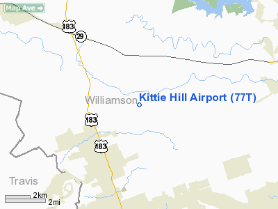
Location & QuickFacts
| FAA Information Effective: | 2008-09-25 |
| Airport Identifier: | 77T |
| Airport Status: | Operational |
| Longitude/Latitude: | 097-49-08.0450W/30-36-07.6970N
-97.818901/30.602138 (Estimated) |
| Elevation: | 1020 ft / 310.90 m (Estimated) |
| Land: | 148 acres |
| From nearest city: | 3 nautical miles E of Leander, TX |
| Location: | Williamson County, TX |
| Magnetic Variation: | 07E (1985) |
Owner & Manager
| Ownership: | Privately owned |
| Owner: | Charles F Densford Jr |
| Address: | 506 Riverview Dr
Georgetown, TX 78668 |
| Phone number: | 512-930-4717
OR 512-930-4717/512-259-8446. |
| Manager: | Charles F Densford Jr |
| Address: | 17501 Ronald Regan Blvd
Leander, TX 78641 |
| Phone number: | 512-259-0350 |
Airport Operations and Facilities
| Airport Use: | Open to public |
| Wind indicator: | Yes |
| Segmented Circle: | Yes |
| Control Tower: | No |
| Landing fee charge: | No |
| Sectional chart: | San Antonio |
| Region: | ASW - Southwest |
| Boundary ARTCC: | ZHU - Houston |
| Tie-in FSS: | SJT - San Angelo |
| FSS on Airport: | No |
| FSS Toll Free: | 1-800-WX-BRIEF |
| NOTAMs Facility: | SJT (NOTAM-d service avaliable) |
Airport Communications
Airport Services
| Fuel available: | 100LL
CALL FOR FUEL AVAILABILITY 512-259-0350. |
| Airframe Repair: | MAJOR |
| Power Plant Repair: | MAJOR |
Runway Information
Runway 07/25
| Dimension: | 3450 x 55 ft / 1051.6 x 16.8 m |
| Surface: | TURF, Good Condition |
| |
Runway 07 |
Runway 25 |
| Traffic Pattern: | Left | Right |
| Markings: | Numbers only, Poor Condition
RYS 07/25, 12/30 & 17/35 15 FT TALL RY NRS; OVERGROWN WITH GRASS. | Numbers only, Poor Condition
NRS FADED. |
| Obstruction: | 30 ft tree, 35 ft left of centerline | 30 ft trees, 0.0 ft from runway, 45L/ ft right of centerline |
|
Runway 12/30
| Dimension: | 2620 x 55 ft / 798.6 x 16.8 m |
| Surface: | TURF, Good Condition |
| |
Runway 12 |
Runway 30 |
| Traffic Pattern: | Left | Right |
| Markings: | Numbers only, Poor Condition | Numbers only, Poor Condition |
| Obstruction: | 40 ft trees, 60 ft left of centerline | 30 ft tree, 0.0 ft from runway, 100 ft left of centerline |
|
Runway 17/35
| Dimension: | 2350 x 60 ft / 716.3 x 18.3 m |
| Surface: | TURF, Good Condition |
| |
Runway 17 |
Runway 35 |
| Traffic Pattern: | Left | Right |
| Markings: | Numbers only, Poor Condition | Numbers only, Poor Condition |
| Obstruction: | 20 ft trees | 5 ft fence, 0.0 ft from runway |
|
Radio Navigation Aids
| ID |
Type |
Name |
Ch |
Freq |
Var |
Dist |
| GUO | NDB | Georgetown | | 332.00 | 06E | 8.7 nm |
| BMQ | NDB | Burnet | | 341.00 | 07E | 23.1 nm |
| IL | NDB | Iresh | | 278.00 | 07E | 26.0 nm |
| MFS | NDB | Horseshoe Bay Resort | | 403.00 | 07E | 28.3 nm |
| HLR | NDB | Hood | | 347.00 | 07E | 32.2 nm |
| GR | NDB | Starn | | 323.00 | 07E | 34.1 nm |
| GRK | VOR/DME | Gray | 055X | 111.80 | 07E | 25.9 nm |
| TPL | VOR/DME | Temple | 041X | 110.40 | 09E | 41.8 nm |
| CWK | VORTAC | Centex | 075X | 112.80 | 06E | 20.1 nm |
| LZZ | VORTAC | Lampasas | 072X | 112.50 | 08E | 38.8 nm |
Remarks
- HEAVY EQUIPMENT OCCASIONALLY ON RY.
- +25' PLINE 200' FM END RY 25.
- FOR REPAIRS CALL 512-259-9146.
- FOR ARPT ADVISORY CALL 512-259-0350.
- CONSTRUCTION EAST SIDE OF ARPT.
- PRVDD MNM 20:1 APCH SLOPE MAINTD TO EACH RWY END.
Images and information placed above are from
http://www.airport-data.com/airport/77T/
We thank them for the data!
| General Info
|
| Country |
United States
|
| State |
TEXAS
|
| FAA ID |
77T
|
| Latitude |
30-36-07.697N
|
| Longitude |
097-49-08.045W
|
| Elevation |
1020 feet
|
| Near City |
LEANDER
|
We don't guarantee the information is fresh and accurate. The data may
be wrong or outdated.
For more up-to-date information please refer to other sources.
|
|


