 |
|
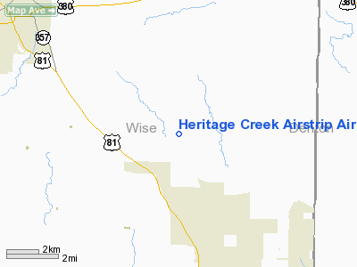
Heritage Creek Airstrip Airport |
Location & QuickFacts
| FAA Information Effective: | 2008-09-25 |
| Airport Identifier: | 58T |
| Airport Status: | Operational |
| Longitude/Latitude: | 097-29-03.0860W/33-10-07.4300N
-97.484191/33.168731 (Estimated) |
| Elevation: | 883 ft / 269.14 m (Estimated) |
| Land: | 6 acres |
| From nearest city: | 9 nautical miles SE of Decatur, TX |
| Location: | Wise County, TX |
| Magnetic Variation: | 07E (1985) |
Owner & Manager
| Ownership: | Privately owned |
| Owner: | Heritage Creek Pilots Assoc |
| Address: | 894 Heritage Creek Drive
Rhome, TX 76078 |
| Phone number: | 940-627-5938 |
| Manager: | William Goebel, President |
| Address: | 894 Heritage Creek Drive
Rhome, TX 76078 |
| Phone number: | 940-627-5938 |
Airport Operations and Facilities
| Airport Use: | Open to public |
| Wind indicator: | Yes |
| Segmented Circle: | No |
| Control Tower: | No |
| Lighting Schedule: | RDO-CTL
ACTVT LIRL RY 13/31 - CTAF. |
| Sectional chart: | Dallas-ft Worth |
| Region: | ASW - Southwest |
| Traffic Pattern Alt: | 800 ft |
| Boundary ARTCC: | ZFW - Fort Worth |
| Tie-in FSS: | FTW - Fort Worth |
| FSS on Airport: | No |
| FSS Phone: | 817-541-3474 |
| FSS Toll Free: | 1-800-WX-BRIEF |
| NOTAMs Facility: | FTW (NOTAM-d service avaliable) |
Airport Communications
Runway Information
Runway 13/31
| Dimension: | 3000 x 60 ft / 914.4 x 18.3 m |
| Surface: | TURF, Good Condition |
| Edge Lights: | Low |
| |
Runway 13 |
Runway 31 |
| Traffic Pattern: | Right | Right |
| Obstruction: | 11 ft tree, 180.0 ft from runway, 25 ft right of centerline, 16:1 slope to clear | 23 ft tree, 740.0 ft from runway, 70 ft right of centerline, 32:1 slope to clear |
|
Radio Navigation Aids
| ID |
Type |
Name |
Ch |
Freq |
Var |
Dist |
| GMZ | NDB | Grindstone Mountain | | 356.00 | 07E | 30.0 nm |
| GLE | NDB | Gainesville | | 330.00 | 06E | 36.0 nm |
| MWL | NDB | Mineral Wells | | 266.00 | 06E | 37.0 nm |
| RBD | NDB | Redbird | | 287.00 | 06E | 42.8 nm |
| XQH | NDB | Cedar Hill | | 353.00 | 08E | 43.2 nm |
| GZV | NDB | Brazos River | | 280.00 | 07E | 48.6 nm |
| NFW | TACAN | Nas Jrb Fort Worth | 024X | | 07E | 24.0 nm |
| TTT | VOR/DME | Maverick | 078X | 113.10 | 06E | 28.7 nm |
| CVE | VOR/DME | Cowboy | 109X | 116.20 | 06E | 33.7 nm |
| FUZ | VORTAC | Ranger | 104X | 115.70 | 06E | 22.8 nm |
| UKW | VORTAC | Bowie | 071X | 112.40 | 06E | 27.8 nm |
| MQP | VORTAC | Millsap | 124X | 117.70 | 09E | 37.1 nm |
| FTW | VOT | Fort Worth Meacham | | 108.20 | | 22.0 nm |
| DAL | VOT | Dallas Love Field | | 113.30 | | 37.3 nm |
Remarks
- BIRD ACTIVITY SOUTH OF ARPT.
- ALL ACFT MONITOR CTAF DUE TO THE CLOSE PROXIMITY TO RHOME MEADOWS ARPT.
Images and information placed above are from
http://www.airport-data.com/airport/58T/
We thank them for the data!
|
|


