 |
|
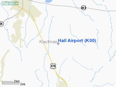
Location & QuickFacts
| FAA Information Effective: | 2008-09-25 |
| Airport Identifier: | K00 |
| Airport Status: | Operational |
| Longitude/Latitude: | 096-14-12.7100W/32-30-49.4900N
-96.236864/32.513747 (Estimated) |
| Elevation: | 440 ft / 134.11 m (Estimated) |
| Land: | 27 acres |
| From nearest city: | 6 nautical miles NW of Kaufman, TX |
| Location: | Kaufman County, TX |
| Magnetic Variation: | 07E (1980) |
Owner & Manager
| Ownership: | Privately owned |
| Owner: | Ronald R. Hall |
| Address: | 6261 County Rd 149
Kaufman, TX 75142 |
| Phone number: | 972-962-0539 |
| Manager: | Bob Hall |
| Address: | 6261 County Rd 149
Kaufman, TX 75142 |
| Phone number: | 972-962-5099 |
Airport Operations and Facilities
| Airport Use: | Open to public |
| Segmented Circle: | No |
| Control Tower: | No |
| Sectional chart: | Dallas-ft Worth |
| Region: | ASW - Southwest |
| Boundary ARTCC: | ZFW - Fort Worth |
| Tie-in FSS: | FTW - Fort Worth |
| FSS Phone: | 817-541-3474 |
| FSS Toll Free: | 1-800-WX-BRIEF |
| NOTAMs Facility: | FTW (NOTAM-d service avaliable) |
Airport Communications
| CTAF: | 122.800 |
| Unicom: | 122.800 |
Runway Information
Runway 17/35
| Dimension: | 2585 x 40 ft / 787.9 x 12.2 m |
| Surface: | TURF, Poor Condition
GRASS HIGH AND ROUGH. |
| |
Runway 17 |
Runway 35 |
| Traffic Pattern: | Left | Left |
| Obstruction: | 30 ft trees, 280.0 ft from runway, 9:1 slope to clear | 8 ft tree, 87.0 ft from runway, 50 ft right of centerline, 10:1 slope to clear |
|
Radio Navigation Aids
| ID |
Type |
Name |
Ch |
Freq |
Var |
Dist |
| AVZ | NDB | Travis | | 260.00 | 06E | 14.8 nm |
| JUG | NDB | Jecca | | 388.00 | 06E | 17.6 nm |
| PQF | NDB | Mesquite | | 248.00 | 06E | 23.1 nm |
| LNC | NDB | Lancaster | | 239.00 | 06E | 24.9 nm |
| CGQ | NDB | Powell | | 344.00 | 06E | 28.7 nm |
| SYW | NDB | Cash | | 428.00 | 05E | 29.4 nm |
| AHX | NDB | Athens | | 269.00 | 06E | 29.7 nm |
| CRS | NDB | Corsicana | | 396.00 | 06E | 30.3 nm |
| CSZ | NDB | Crossroads | | 215.00 | 08E | 30.6 nm |
| MII | NDB | Caddo Mills | | 316.00 | 06E | 31.7 nm |
| LIQ | NDB | Lochridge Ranch | | 335.00 | 09E | 33.5 nm |
| RBD | NDB | Redbird | | 287.00 | 06E | 33.6 nm |
| XQH | NDB | Cedar Hill | | 353.00 | 08E | 37.8 nm |
| PYF | NDB | Pyramid | | 418.00 | 06E | 39.2 nm |
| TY | NDB | Tyler | | 320.00 | 06E | 39.4 nm |
| MJF | TACAN | Arvilla | 033X | | 05E | 34.4 nm |
| CVE | VOR/DME | Cowboy | 109X | 116.20 | 06E | 40.6 nm |
| TYR | VOR/DME | Tyler | 089X | 114.20 | 06E | 43.3 nm |
| FZT | VOR/DME | Frankston | 051X | 111.40 | 06E | 44.5 nm |
| TTT | VOR/DME | Maverick | 078X | 113.10 | 06E | 45.9 nm |
| UIM | VOR/DME | Quitman | 087X | 114.00 | 08E | 49.2 nm |
| CQY | VORTAC | Cedar Creek | 095X | 114.80 | 06E | 19.7 nm |
| DAL | VOT | Dallas Love Field | | 113.30 | | 37.0 nm |
Remarks
- +4 FT FENCE 40 FT EAST RY CNTRLN OBSTRUCTS SAFETY AREA, SCATTERED 12 FT TREES IN FENCE LINE.
- +3 FT GRASS COVERING PAINTED TIRES MARKING THLD.
Images and information placed above are from
http://www.airport-data.com/airport/K00/
We thank them for the data!
| General Info
|
| Country |
United States
|
| State |
TEXAS
|
| FAA ID |
30TS
|
| Latitude |
32-49-42.483N
|
| Longitude |
094-43-07.746W
|
| Elevation |
350 feet
|
| Near City |
ORE CITY
|
We don't guarantee the information is fresh and accurate. The data may
be wrong or outdated.
For more up-to-date information please refer to other sources.
|
|


