 |
|
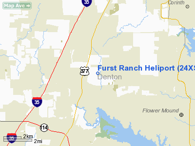
Location & QuickFacts
| FAA Information Effective: | 2008-09-25 |
| Airport Identifier: | 24XS |
| Airport Status: | Operational |
| Longitude/Latitude: | 097-10-56.0000W/33-04-33.0000N
-97.182222/33.075833 (Estimated) |
| Elevation: | 725 ft / 220.98 m (Estimated) |
| Land: | 0 acres |
| From nearest city: | 3 nautical miles S of Argyle, TX |
| Location: | Denton County, TX |
| Magnetic Variation: | 06E (2000) |
Owner & Manager
| Ownership: | Privately owned |
| Owner: | Jack D. Furst |
| Address: | 1157 W Jeter Road
Argyle, TX 76226 |
| Manager: | Chuck Michlin/j.e.t. Inc |
| Address: | 9301 Weiss Street Hangar D
Dallas, TX 75235 |
| Phone number: | 214-358-4411 |
Airport Operations and Facilities
| Airport Use: | Private |
| Segmented Circle: | No |
| Control Tower: | No |
| Lighting Schedule: | PHONE REQ
FOR PERIMETER LGTS CALL 214-358-4411. |
| Sectional chart: | Dallas-ft Worth |
| Region: | ASW - Southwest |
| Boundary ARTCC: | ZFW - Fort Worth |
| Tie-in FSS: | FTW - Fort Worth |
| FSS Phone: | 817-541-3474 |
| FSS Toll Free: | 1-800-WX-BRIEF |
Runway Information
Helipad H1
| Dimension: | 25 x 25 ft / 7.6 x 7.6 m |
| Surface: | CONC, Good Condition |
| |
Runway H1 |
Runway |
| Traffic Pattern: | Left | Left |
|
Radio Navigation Aids
| ID |
Type |
Name |
Ch |
Freq |
Var |
Dist |
| RBD | NDB | Redbird | | 287.00 | 06E | 28.7 nm |
| XQH | NDB | Cedar Hill | | 353.00 | 08E | 30.9 nm |
| PQF | NDB | Mesquite | | 248.00 | 06E | 36.6 nm |
| LNC | NDB | Lancaster | | 239.00 | 06E | 37.9 nm |
| GLE | NDB | Gainesville | | 330.00 | 06E | 38.6 nm |
| JUG | NDB | Jecca | | 388.00 | 06E | 41.0 nm |
| GMZ | NDB | Grindstone Mountain | | 356.00 | 07E | 43.5 nm |
| MII | NDB | Caddo Mills | | 316.00 | 06E | 47.1 nm |
| MWL | NDB | Mineral Wells | | 266.00 | 06E | 47.5 nm |
| NFW | TACAN | Nas Jrb Fort Worth | 024X | | 07E | 22.4 nm |
| TTT | VOR/DME | Maverick | 078X | 113.10 | 06E | 14.3 nm |
| CVE | VOR/DME | Cowboy | 109X | 116.20 | 06E | 17.9 nm |
| FUZ | VORTAC | Ranger | 104X | 115.70 | 06E | 11.2 nm |
| UKW | VORTAC | Bowie | 071X | 112.40 | 06E | 42.4 nm |
| MQP | VORTAC | Millsap | 124X | 117.70 | 09E | 46.2 nm |
| FTW | VOT | Fort Worth Meacham | | 108.20 | | 17.9 nm |
| DAL | VOT | Dallas Love Field | | 113.30 | | 21.6 nm |
Images and information placed above are from
http://www.airport-data.com/airport/24XS/
We thank them for the data!
| General Info
|
| Country |
United States
|
| State |
TEXAS
|
| FAA ID |
24XS
|
| Latitude |
33-04-33.000N
|
| Longitude |
097-10-56.000W
|
| Elevation |
725 feet
|
| Near City |
ARGYLE
|
We don't guarantee the information is fresh and accurate. The data may
be wrong or outdated.
For more up-to-date information please refer to other sources.
|
|


