 |
|
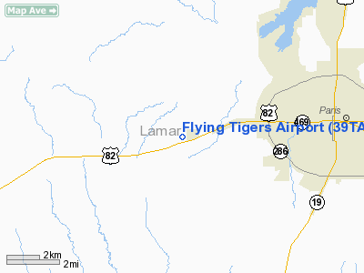
Location & QuickFacts
| FAA Information Effective: | 2008-09-25 |
| Airport Identifier: | 39TA |
| Airport Status: | Operational |
| Longitude/Latitude: | 095-39-20.8570W/33-39-09.3760N
-95.655794/33.652604 (Estimated) |
| Elevation: | 588 ft / 179.22 m (Surveyed) |
| Land: | 30 acres |
| From nearest city: | 5 nautical miles W of Paris, TX |
| Location: | Lamar County, TX |
| Magnetic Variation: | 06E (1985) |
Owner & Manager
| Ownership: | Privately owned |
| Owner: | I.n. Burchinal |
| Address: | 615 38 S.e.
Paris, TX 75460 |
| Phone number: | 214-784-3613 |
| Manager: | I N Burchinal |
| Address: | 615 38 S.e.
Paris, TX 75460 |
| Phone number: | 214-784-0688 |
Airport Operations and Facilities
| Airport Use: | Private |
| Wind indicator: | Yes |
| Segmented Circle: | No |
| Control Tower: | No |
| Landing fee charge: | No |
| Sectional chart: | Dallas-ft Worth |
| Region: | ASW - Southwest |
| Boundary ARTCC: | ZFW - Fort Worth |
| Tie-in FSS: | FTW - Fort Worth |
| FSS on Airport: | No |
| FSS Phone: | 817-541-3474 |
| FSS Toll Free: | 1-800-WX-BRIEF |
Airport Services
| Airframe Repair: | MINOR |
| Power Plant Repair: | MINOR |
| Bottled Oxygen: | NONE |
| Bulk Oxygen: | NONE |
Runway Information
Runway 02/20
| Dimension: | 2380 x 20 ft / 725.4 x 6.1 m
4150' X 75': 2380' X 20' ASPH WITH ADNL 28' DIRT EACH SIDE & 1400' X 75' DIRT AVBL IN DRY WX.
WIDTH VARIES DUE TO GRASS ENCROACH AND POOR PAVEMENT. |
| Surface: | ASPH, Poor Condition |
| Weight Limit: | Single wheel: 5000 lbs. |
| |
Runway 02 |
Runway 20 |
| Traffic Pattern: | Left | Left |
| Markings: | None, | None, |
| Runway End Identifier: | No | No |
| Centerline Lights: | No | No |
| Touchdown Lights: | No | No |
| Obstruction: | 30 ft pline, 200.0 ft from runway, 125 ft right of centerline
APCH RATIO/CLOSE-IN OBSTNS MEASURED FROM ASPH RWY.
+16' AIRPLANE 80' FROM THR 45' LEFT OF CNTRLN. | , 50:1 slope to clear
APCH RATIO 0:1 FROM DIRT END.
+20' TREES AT THR 65' LEFT OF CNTRLN. |
|
Runway 16/34
| Dimension: | 1375 x 80 ft / 419.1 x 24.4 m
4150' X 75': 2380' X 20' ASPH WITH ADNL 28' DIRT EACH SIDE & 1400' X 75' DIRT AVBL IN DRY WX.
WIDTH VARIES DUE TO GRASS ENCROACH AND POOR PAVEMENT. |
| Surface: | TURF, Poor Condition |
| |
Runway 16 |
Runway 34 |
| Traffic Pattern: | Left | Left |
| Markings: | None, | None, |
| Runway End Identifier: | No | No |
| Centerline Lights: | No | No |
| Touchdown Lights: | No | No |
| Obstruction: | 35 ft tree, 185.0 ft from runway, 5:1 slope to clear | 27 ft tree, 0.0 ft from runway, 30 ft left of centerline |
|
Radio Navigation Aids
| ID |
Type |
Name |
Ch |
Freq |
Var |
Dist |
| HHW | NDB | Hugo | | 323.00 | 05E | 24.0 nm |
| HJM | NDB | Rayburn | | 415.00 | 06E | 26.1 nm |
| AEE | NDB | Antlers | | 391.00 | 05E | 32.4 nm |
| DUA | NDB | Durant | | 359.00 | 05E | 41.0 nm |
| IBO | NDB | Idabel | | 271.00 | 03E | 43.4 nm |
| SYW | NDB | Cash | | 428.00 | 05E | 45.3 nm |
| MII | NDB | Caddo Mills | | 316.00 | 06E | 47.3 nm |
| MJF | TACAN | Arvilla | 033X | | 05E | 40.7 nm |
| PRX | VOR/DME | Paris | 083X | 113.60 | 07E | 12.3 nm |
| SLR | VOR/DME | Sulphur Springs | 027X | 109.00 | 08E | 27.9 nm |
| URH | VOR/DME | Texoma | 090X | 114.30 | 05E | 40.7 nm |
| UIM | VOR/DME | Quitman | 087X | 114.00 | 08E | 48.6 nm |
| BYP | VORTAC | Bonham | 093X | 114.60 | 06E | 29.8 nm |
Remarks
- RWY 02/20 VERY POOR COND; CTN ADZD WHEN USING RWY 16/34 OR E/W TWY DUE TO HIGH GRASS.
Images and information placed above are from
http://www.airport-data.com/airport/39TA/
We thank them for the data!
| General Info
|
| Country |
United States
|
| State |
TEXAS
|
| FAA ID |
39TA
|
| Latitude |
33-39-09.376N
|
| Longitude |
095-39-20.857W
|
| Elevation |
588 feet
|
| Near City |
PARIS
|
We don't guarantee the information is fresh and accurate. The data may
be wrong or outdated.
For more up-to-date information please refer to other sources.
|
|


