 |
|
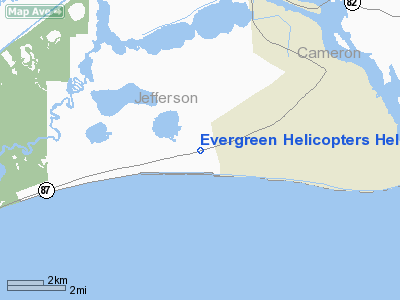
Evergreen Helicopters Heliport |
Location & QuickFacts
| FAA Information Effective: | 2008-09-25 |
| Airport Identifier: | 51XS |
| Airport Status: | Operational |
| Longitude/Latitude: | 093-58-00.6090W/29-41-35.7890N
-93.966836/29.693275 (Estimated) |
| Elevation: | 10 ft / 3.05 m (Estimated) |
| Land: | 0 acres |
| From nearest city: | 4 nautical miles W of Sabine Pass, TX |
| Location: | Jefferson County, TX |
| Magnetic Variation: | 05E (1985) |
Owner & Manager
| Ownership: | Privately owned |
| Owner: | Evergreen Helicopters Inc. |
| Address: | Rt 3, Box 1913
Galveston, TX 77553 |
| Phone number: | 409-740-0231 |
| Manager: | Michael Williamson |
| Address: | Rt 3, Box 19b
Galveston, TX 77554 |
| Phone number: | 409-740-0231 |
Airport Operations and Facilities
| Airport Use: | Private |
| Wind indicator: | Yes |
| Segmented Circle: | No |
| Control Tower: | No |
| Lighting Schedule: | PHONE REQ
FOR PERIMETER LGTS CALL 409-740-0231. |
| Landing fee charge: | No |
| Sectional chart: | Houston |
| Region: | ASW - Southwest |
| Boundary ARTCC: | ZHU - Houston |
| Tie-in FSS: | CXO - Montgomery County |
| FSS on Airport: | No |
| FSS Toll Free: | 1-800-WX-BRIEF
FOR FP FILING CALL CXO FSS 1-800-833-5602. |
Runway Information
Helipad H1
| Dimension: | 450 x 450 ft / 137.2 x 137.2 m |
| Surface: | CONC, |
| |
Runway H1 |
Runway |
| Traffic Pattern: | Left | Left |
|
Radio Navigation Aids
| ID |
Type |
Name |
Ch |
Freq |
Var |
Dist |
| ORG | NDB | Orange | | 211.00 | 05E | 24.4 nm |
| GDE | NDB | Goodhue | | 368.00 | 07E | 25.7 nm |
| CBC | NDB | Anahuac | | 413.00 | 05E | 36.6 nm |
| UX | NDB | Sulfy | | 278.00 | 04E | 41.6 nm |
| HRD | NDB | Hardin County | | 524.00 | 04E | 41.6 nm |
| GLS | NDB | Galveston | | 206.00 | 08E | 46.6 nm |
| SBI | VOR/DME | Sabine Pass | 101X | 115.40 | 07E | 3.7 nm |
| BPT | VOR/DME | Beaumont | 092X | 114.50 | 07E | 15.4 nm |
| MHF | VOR/DME | Trinity | 083X | 113.60 | 07E | 41.7 nm |
| DAS | VORTAC | Daisetta | 116X | 116.90 | 05E | 46.2 nm |
Images and information placed above are from
http://www.airport-data.com/airport/51XS/
We thank them for the data!
| General Info
|
| Country |
United States
|
| State |
TEXAS
|
| FAA ID |
51XS
|
| Latitude |
29-41-35.789N
|
| Longitude |
093-58-00.609W
|
| Elevation |
10 feet
|
| Near City |
SABINE PASS
|
We don't guarantee the information is fresh and accurate. The data may
be wrong or outdated.
For more up-to-date information please refer to other sources.
|
|


