|
|
 |
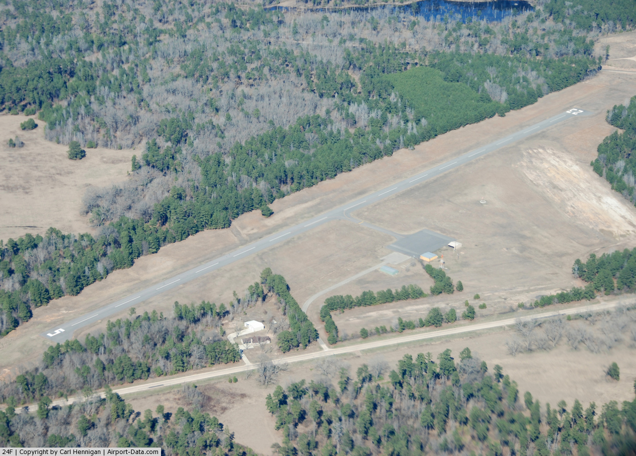
(Click on the photo to enlarge) |
Location & QuickFacts
| FAA Information Effective: | 2008-09-25 |
| Airport Identifier: | 24F |
| Airport Status: | Operational |
| Longitude/Latitude: | 094-18-16.7690W/32-44-39.4950N
-94.304658/32.744304 (Estimated) |
| Elevation: | 221 ft / 67.36 m (Estimated) |
| Land: | 100 acres |
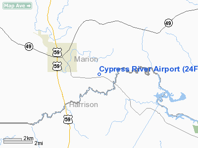
| From nearest city: | 3 nautical miles E of Jefferson, TX |
| Location: | Marion County, TX |
| Magnetic Variation: | 05E (1985) |
Owner & Manager
| Ownership: | Publicly owned |
| Owner: | Marion County |
| Address: | Marion Co Courthouse
Jefferson, TX 75657 |
| Phone number: | 903-665-3261 |
| Manager: | Ray Keasler
COUNTY JUDGE, CALL FOR TRANSPORTATION MON-FRI 0800-1700. |
| Address: | P.o. Box 548
Jefferson, TX 75657 |
| Phone number: | 903-665-3261 |
Airport Operations and Facilities
| Airport Use: | Open to public |
| Wind indicator: | Yes |
| Segmented Circle: | No |
| Control Tower: | No |
| Lighting Schedule: | DUSK-DAWN |
| Landing fee charge: | No |
| Sectional chart: | Memphis |
| Region: | ASW - Southwest |
| Boundary ARTCC: | ZFW - Fort Worth |
| Tie-in FSS: | FTW - Fort Worth |
| FSS on Airport: | No |
| FSS Phone: | 817-541-3474 |
| FSS Toll Free: | 1-800-WX-BRIEF |
| NOTAMs Facility: | FTW (NOTAM-d service avaliable) |
| Federal Agreements: | Y1 |
Airport Communications
Airport Services
| Airframe Repair: | NONE |
| Power Plant Repair: | NONE |
| Bottled Oxygen: | NONE |
| Bulk Oxygen: | NONE |
Runway Information
Runway 05/23
| Dimension: | 3200 x 60 ft / 975.4 x 18.3 m |
| Surface: | ASPH, Good Condition |
| Weight Limit: | Single wheel: 12500 lbs. |
| Edge Lights: | Low |
| |
Runway 05 |
Runway 23 |
| Traffic Pattern: | Left | Left |
| Markings: | Basic, Good Condition | Basic, Good Condition |
| Obstruction: | 29 ft trees, 335.0 ft from runway, 40 ft left of centerline, 4:1 slope to clear
15-30 FT TREES 50-150 FT FM THLD 100 FT R & L. | 84 ft trees, 1280.0 ft from runway, 12:1 slope to clear
+4 FT RISING GND 200 FT FM THLD 75 FT R. |
|
Radio Navigation Aids
| ID |
Type |
Name |
Ch |
Freq |
Var |
Dist |
| VIV | NDB | Vivian | | 284.00 | 06E | 16.4 nm |
| ATA | NDB | Atlanta | | 347.00 | 04E | 22.4 nm |
| LST | NDB | Lone Star | | 305.00 | 05E | 24.7 nm |
| RPF | NDB | Carthage | | 332.00 | 04E | 33.9 nm |
| ABG | NDB | Ambassador | | 404.00 | 07E | 42.0 nm |
| HNO | NDB | Henderson | | 371.00 | 06E | 43.8 nm |
| SPH | NDB | Springhill | | 375.00 | 05E | 46.4 nm |
| MSD | NDB | Mansfield | | 414.00 | 04E | 49.2 nm |
| BAD | TACAN | Barksdale | 105X | | 05E | 35.3 nm |
| DTN | VOR | Downtown | | 108.60 | 07E | 31.0 nm |
| EIC | VORTAC | Belcher | 121X | 117.40 | 07E | 25.1 nm |
| GGG | VORTAC | Gregg County | 070X | 112.30 | 07E | 30.0 nm |
| EMG | VORTAC | Elm Grove | 049X | 111.20 | 07E | 41.5 nm |
| TXK | VORTAC | Texarkana | 110X | 116.30 | 07E | 47.7 nm |
| SHV | VOT | Shreveport Regional | | 108.20 | | 24.9 nm |
Remarks
- CAUTION:RWY 05 - 5' DITCH 45' LEFT AT THR; DECREASING TO ZERO DEPTH 500' EAST OF THR.
- DEER ON & INVOF ARPT.
Images and information placed above are from
http://www.airport-data.com/airport/24F/
We thank them for the data!
| General Info
|
| Country |
United States
|
| State |
TEXAS
|
| FAA ID |
24F
|
| Latitude |
32-44-45.508N
|
| Longitude |
094-18-15.687W
|
| Elevation |
221 feet
|
| Near City |
JEFFERSON
|
We don't guarantee the information is fresh and accurate. The data may
be wrong or outdated.
For more up-to-date information please refer to other sources.
|
|