 |
|
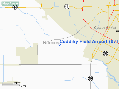
Location & QuickFacts
| FAA Information Effective: | 2008-09-25 |
| Airport Identifier: | 07TE |
| Airport Status: | Operational |
| Longitude/Latitude: | 097-30-45.9760W/27-43-16.1050N
-97.512771/27.721140 (Estimated) |
| Elevation: | 39 ft / 11.89 m (Surveyed) |
| Land: | 803 acres |
| From nearest city: | 7 nautical miles SW of Corpus Christi, TX |
| Location: | Nueces County, TX |
| Magnetic Variation: | 07E (1985) |
Owner & Manager
| Ownership: | Privately owned |
| Address: |
|
| Manager: | Jimmy C. Adair |
| Address: | Box 9056
Corpus Christi, TX 78469 |
Airport Operations and Facilities
| Airport Use: | Private |
| Wind indicator: | No |
| Segmented Circle: | No |
| Control Tower: | No |
| Landing fee charge: | No |
| Sectional chart: | Brownsville |
| Region: | ASW - Southwest |
| Boundary ARTCC: | ZHU - Houston |
| Tie-in FSS: | SJT - San Angelo |
| FSS on Airport: | No |
| FSS Toll Free: | 1-800-WX-BRIEF |
Airport Services
| Airframe Repair: | NONE |
| Power Plant Repair: | NONE |
Runway Information
Runway 13/31
| Dimension: | 5000 x 100 ft / 1524.0 x 30.5 m |
| Surface: | ASPH, |
| |
Runway 13 |
Runway 31 |
| Traffic Pattern: | Left | Left |
| Approach lights: | SSALR | |
|
Radio Navigation Aids
| ID |
Type |
Name |
Ch |
Freq |
Var |
Dist |
| TKB | NDB | Kleberg County | | 347.00 | 06E | 31.3 nm |
| RKP | NDB | Rockport | | 391.00 | 06E | 33.3 nm |
| MNO | NDB | Mellon Ranch | | 375.00 | 06E | 37.3 nm |
| BEA | NDB | Beeville | | 284.00 | 07E | 41.7 nm |
| BKS | NDB | Brooks County | | 353.00 | 06E | 44.8 nm |
| NQI | TACAN | Kingsville | 125X | | 09E | 20.5 nm |
| NOG | TACAN | Orange Grove | 063X | | 09E | 30.1 nm |
| ALI | VOR | Alice | | 114.50 | 06E | 27.1 nm |
| CRP | VORTAC | Corpus Christi | 102X | 115.50 | 09E | 11.6 nm |
| NGP | VORTAC | Truax | 087X | 114.00 | 06E | 11.8 nm |
Remarks
- NO SIGNIFICANT INCREASE IN TOTAL ACFT OPERNS OVER 12,000. OPERNS CONFINED RNWY 13/31.
Images and information placed above are from
http://www.airport-data.com/airport/07TE/
We thank them for the data!
| General Info
|
| Country |
United States
|
| State |
TEXAS
|
| FAA ID |
07TE
|
| Latitude |
27-43-16.105N
|
| Longitude |
097-30-45.976W
|
| Elevation |
39 feet
|
| Near City |
CORPUS CHRISTI
|
We don't guarantee the information is fresh and accurate. The data may
be wrong or outdated.
For more up-to-date information please refer to other sources.
|
|


