 |
|
Location & QuickFacts
| FAA Information Effective: | 2008-09-25 |
| Airport Identifier: | 05TX |
| Airport Status: | Operational |
| Longitude/Latitude: | 097-24-15.0000W/32-07-45.0000N
-97.404167/32.129167 (Estimated) |
| Elevation: | 608 ft / 185.32 m (Estimated) |
| Land: | 0 acres |
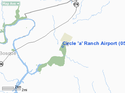
| From nearest city: | 1 nautical miles S of Blum, TX |
| Location: | Hill County, TX |
| Magnetic Variation: | 07E (1990) |
Owner & Manager
| Ownership: | Privately owned |
| Owner: | William Gary Ashmore |
| Address: | 7265 Fm 933
Blum, TX 76627 |
| Phone number: | 254-874-5459 |
| Manager: | William Gary Ashmore |
| Address: | 7265 Fm 933
Blum, TX 76627 |
| Phone number: | 254-874-5459 |
Airport Operations and Facilities
| Airport Use: | Private |
| Segmented Circle: | No |
| Control Tower: | No |
| Sectional chart: | Dallas-ft Worth |
| Region: | ASW - Southwest |
| Boundary ARTCC: | ZFW - Fort Worth |
| Tie-in FSS: | FTW - Fort Worth |
| FSS on Airport: | No |
| FSS Phone: | 817-541-3474 |
| FSS Toll Free: | 1-800-WX-BRIEF |
Runway Information
Runway 15/33
| Dimension: | 2075 x 50 ft / 632.5 x 15.2 m |
| Surface: | TURF, |
| |
Runway 15 |
Runway 33 |
| Traffic Pattern: | Left | Left |
|
Radio Navigation Aids
| ID |
Type |
Name |
Ch |
Freq |
Var |
Dist |
| XQH | NDB | Cedar Hill | | 353.00 | 08E | 35.3 nm |
| ROB | NDB | Robinson | | 400.00 | 07E | 41.3 nm |
| RBD | NDB | Redbird | | 287.00 | 06E | 42.6 nm |
| LNC | NDB | Lancaster | | 239.00 | 06E | 43.9 nm |
| MNZ | NDB | Hamilton | | 251.00 | 07E | 48.7 nm |
| CGQ | NDB | Powell | | 344.00 | 06E | 49.9 nm |
| NFW | TACAN | Nas Jrb Fort Worth | 024X | | 07E | 38.7 nm |
| TTT | VOR/DME | Maverick | 078X | 113.10 | 06E | 48.1 nm |
| JEN | VORTAC | Glen Rose | 097X | 115.00 | 06E | 24.2 nm |
| ACT | VORTAC | Waco | 100X | 115.30 | 09E | 28.9 nm |
| MQP | VORTAC | Millsap | 124X | 117.70 | 09E | 46.8 nm |
| FUZ | VORTAC | Ranger | 104X | 115.70 | 06E | 47.1 nm |
| FTW | VOT | Fort Worth Meacham | | 108.20 | | 41.4 nm |
Images and information placed above are from
http://www.airport-data.com/airport/05TX/
We thank them for the data!
| General Info
|
| Country |
United States
|
| State |
TEXAS
|
| FAA ID |
05TX
|
| Latitude |
32-07-45.000N
|
| Longitude |
097-24-15.000W
|
| Elevation |
608 feet
|
| Near City |
BLUM
|
We don't guarantee the information is fresh and accurate. The data may
be wrong or outdated.
For more up-to-date information please refer to other sources.
|
|


