 |
|
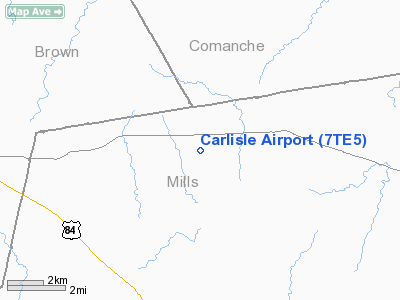
Location & QuickFacts
| FAA Information Effective: | 2008-09-25 |
| Airport Identifier: | 7TE5 |
| Airport Status: | Operational |
| Longitude/Latitude: | 098-39-49.0000W/31-40-45.0000N
-98.663611/31.679167 (Estimated) |
| Elevation: | 1790 ft / 545.59 m (Estimated) |
| Land: | 127 acres |
| From nearest city: | 9 nautical miles N of Mullin, TX |
| Location: | Mills County, TX |
| Magnetic Variation: | 06E (2000) |
Owner & Manager
| Ownership: | Privately owned |
| Owner: | Tommy Ethridge |
| Address: | 15418 Sterling Lake Dr
Houston, TX 77095 |
| Phone number: | 281-463-7731 |
| Manager: | Tommy Ethridge |
| Address: | 15418 Sterling Lake Dr
Houston, TX 77095 |
| Phone number: | 281-463-7731 |
Airport Operations and Facilities
| Airport Use: | Private |
| Segmented Circle: | No |
| Control Tower: | No |
| Sectional chart: | San Antonio |
| Region: | ASW - Southwest |
| Boundary ARTCC: | ZFW - Fort Worth |
| Tie-in FSS: | SJT - San Angelo |
| FSS Toll Free: | 1-800-WX-BRIEF |
Runway Information
Runway 01/19
| Dimension: | 2200 x 60 ft / 670.6 x 18.3 m |
| Surface: | TURF, |
| |
Runway 01 |
Runway 19 |
| Traffic Pattern: | Left | Left |
| Obstruction: | 14 ft trees, 50.0 ft from runway | |
|
Radio Navigation Aids
| ID |
Type |
Name |
Ch |
Freq |
Var |
Dist |
| MNZ | NDB | Hamilton | | 251.00 | 07E | 26.6 nm |
| COM | NDB | Coleman | | 385.00 | 07E | 39.2 nm |
| OIP | NDB | Old Rip | | 410.00 | 07E | 43.9 nm |
| BBD | NDB | Brady | | 380.00 | 07E | 45.3 nm |
| BWD | VOR/DME | Brownwood | 023X | 108.60 | 08E | 19.7 nm |
| LZZ | VORTAC | Lampasas | 072X | 112.50 | 08E | 40.0 nm |
| JEN | VORTAC | Glen Rose | 097X | 115.00 | 06E | 49.4 nm |
Images and information placed above are from
http://www.airport-data.com/airport/7TE5/
We thank them for the data!
|
|


