 |
|
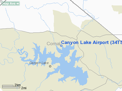
Location & QuickFacts
| FAA Information Effective: | 2008-09-25 |
| Airport Identifier: | 34TS |
| Airport Status: | Operational |
| Longitude/Latitude: | 098-14-51.0500W/29-54-56.7800N
-98.247514/29.915772 (Estimated) |
| Elevation: | 940 ft / 286.51 m (Surveyed) |
| Land: | 22 acres |
| From nearest city: | 2 nautical miles NE of Canyon Lake, TX |
| Location: | Comal County, TX |
| Magnetic Variation: | 08E (1980) |
Owner & Manager
| Ownership: | Privately owned |
| Owner: | Enclave Arpt At Canyon Lake Llc |
| Address: | 801 N. Main St
Boerne, TX 78006 |
| Phone number: | 830-755-4877 |
| Manager: | Steve Dunk |
| Address: | Po Box 1
Fischer, TX 78623 |
| Phone number: | 830-935-2556 |
Airport Operations and Facilities
| Airport Use: | Private |
| Wind indicator: | Yes |
| Segmented Circle: | No |
| Control Tower: | No |
| Landing fee charge: | Yes |
| Sectional chart: | San Antonio |
| Region: | ASW - Southwest |
| Boundary ARTCC: | ZHU - Houston |
| Tie-in FSS: | SJT - San Angelo |
| FSS Toll Free: | 1-800-WX-BRIEF |
Runway Information
Runway 01/19
| Dimension: | 2600 x 45 ft / 792.5 x 13.7 m |
| Surface: | ASPH, |
| |
Runway 01 |
Runway 19 |
| Traffic Pattern: | Right | Left |
| Obstruction: | 150 ft hill, 3300.0 ft from runway | |
|
Radio Navigation Aids
| ID |
Type |
Name |
Ch |
Freq |
Var |
Dist |
| MFS | NDB | Horseshoe Bay Resort | | 403.00 | 07E | 37.0 nm |
| ER | NDB | Shein | | 263.00 | 08E | 39.7 nm |
| CVB | NDB | Castroville | | 338.00 | 08E | 46.5 nm |
| BMQ | NDB | Burnet | | 341.00 | 07E | 49.6 nm |
| DHK | TACAN | Randolph | 036X | | 09E | 22.8 nm |
| KSY | TACAN | Kelly | 057X | | 07E | 36.0 nm |
| SSF | VOR | Stinson | | 108.40 | 09E | 40.8 nm |
| SAT | VORTAC | San Antonio | 115X | 116.80 | 08E | 19.8 nm |
| RND | VORTAC | Randolph | 70X | 112.30 | 09E | 23.9 nm |
| STV | VORTAC | Stonewall | 085X | 113.80 | 08E | 29.6 nm |
| CWK | VORTAC | Centex | 075X | 112.80 | 06E | 46.5 nm |
| SAT | VOT | San Antonio Intl | | 110.40 | | 25.7 nm |
Remarks
Images and information placed above are from
http://www.airport-data.com/airport/34TS/
We thank them for the data!
| General Info
|
| Country |
United States
|
| State |
TEXAS
|
| FAA ID |
34TS
|
| Latitude |
29-53-55.781N
|
| Longitude |
098-12-51.041W
|
| Elevation |
940 feet
|
| Near City |
CANYON LAKE
|
We don't guarantee the information is fresh and accurate. The data may
be wrong or outdated.
For more up-to-date information please refer to other sources.
|
|


