 |
|
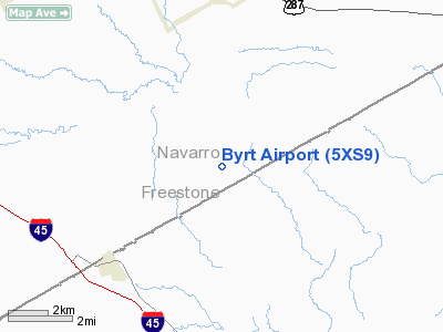
Location & QuickFacts
| FAA Information Effective: | 2008-09-25 |
| Airport Identifier: | 5XS9 |
| Airport Status: | Operational |
| Longitude/Latitude: | 096-15-53.9090W/31-55-18.5770N
-96.264975/31.921827 (Estimated) |
| Elevation: | 414 ft / 126.19 m (Estimated) |
| Land: | 14 acres |
| From nearest city: | 4 nautical miles NE of Streetman, TX |
| Location: | Navarro County, TX |
| Magnetic Variation: | 06E (1985) |
Owner & Manager
| Ownership: | Privately owned |
| Owner: | Scammell Management Llc |
| Address: | 1600 Cheyenne Drive
Richardson, TX 75080-2902 |
| Phone number: | 972-783-7620 |
| Manager: | Catherine Scammel Reed |
| Address: | 1600 Cheyenne Drive
Richardson, TX 75080-2902 |
| Phone number: | 972-783-7620 |
Airport Operations and Facilities
| Airport Use: | Private |
| Wind indicator: | Yes |
| Segmented Circle: | No |
| Control Tower: | No |
| Sectional chart: | Houston |
| Region: | ASW - Southwest |
| Boundary ARTCC: | ZFW - Fort Worth |
| Tie-in FSS: | CXO - Montgomery County |
| FSS Toll Free: | 1-800-WX-BRIEF
FOR FP FILING CALL CXO FSS 1-800-833-5602. |
Runway Information
Runway 14/32
| Dimension: | 4000 x 150 ft / 1219.2 x 45.7 m |
| Surface: | TURF, |
| |
Runway 14 |
Runway 32 |
| Traffic Pattern: | Left | Left |
| Obstruction: | 25 ft pline, 200.0 ft from runway | 25 ft pline, 200.0 ft from runway |
|
Radio Navigation Aids
| ID |
Type |
Name |
Ch |
Freq |
Var |
Dist |
| PYF | NDB | Pyramid | | 418.00 | 06E | 5.0 nm |
| CRS | NDB | Corsicana | | 396.00 | 06E | 9.2 nm |
| CGQ | NDB | Powell | | 344.00 | 06E | 11.9 nm |
| LIQ | NDB | Lochridge Ranch | | 335.00 | 09E | 16.8 nm |
| CSZ | NDB | Crossroads | | 215.00 | 08E | 17.8 nm |
| LXY | NDB | Mexia | | 329.00 | 07E | 21.2 nm |
| AHX | NDB | Athens | | 269.00 | 06E | 26.4 nm |
| PSN | NDB | Palestine | | 375.00 | 04E | 30.0 nm |
| LNC | NDB | Lancaster | | 239.00 | 06E | 45.7 nm |
| JUG | NDB | Jecca | | 388.00 | 06E | 46.9 nm |
| ROB | NDB | Robinson | | 400.00 | 07E | 48.2 nm |
| GNL | VOR/DME | Groesbeck | 025X | 108.80 | 05E | 25.1 nm |
| FZT | VOR/DME | Frankston | 051X | 111.40 | 06E | 38.5 nm |
| CQY | VORTAC | Cedar Creek | 095X | 114.80 | 06E | 16.0 nm |
Remarks
- PRVDD LANDING THRS ARE LCTD TO PRVD A CLEAR 20:1 APCH SLOPE OVER ANY OBSTRUCTIONS IN APCH AREAS.
Images and information placed above are from
http://www.airport-data.com/airport/5XS9/
We thank them for the data!
| General Info
|
| Country |
United States
|
| State |
TEXAS
|
| FAA ID |
5XS9
|
| Latitude |
31-55-18.577N
|
| Longitude |
096-15-53.909W
|
| Elevation |
414 feet
|
| Near City |
STREETMAN
|
We don't guarantee the information is fresh and accurate. The data may
be wrong or outdated.
For more up-to-date information please refer to other sources.
|
|


