 |
|
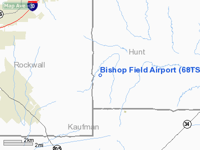
Location & QuickFacts
| FAA Information Effective: | 2008-09-25 |
| Airport Identifier: | 68TS |
| Airport Status: | Operational |
| Longitude/Latitude: | 096-17-15.9270W/32-52-30.4460N
-96.287758/32.875124 (Estimated) |
| Elevation: | 550 ft / 167.64 m (Estimated) |
| Land: | 0 acres |
| From nearest city: | 6 nautical miles SE of Royce City, TX |
| Location: | Hunt County, TX |
| Magnetic Variation: | 06E (1985) |
Owner & Manager
| Ownership: | Privately owned |
| Owner: | W E Bishop |
| Address: | 2812 Live Oak
Dallas, TX 75204 |
| Phone number: | 214-636-9319 |
| Manager: | W E Bishop |
| Address: | Rt 1 Box 58f
Royce City, TX 75089 |
| Phone number: | 214-636-9319 |
Airport Operations and Facilities
| Airport Use: | Private |
| Wind indicator: | Yes |
| Segmented Circle: | No |
| Control Tower: | No |
| Lighting Schedule: | RDO-CTL
ACTVT ROTG BCN & LIRL RY 02/20 - UNICOM. |
| Beacon Color: | Clear-Green (lighted land airport) |
| Sectional chart: | Dallas-ft Worth |
| Region: | ASW - Southwest |
| Boundary ARTCC: | ZFW - Fort Worth |
| Tie-in FSS: | FTW - Fort Worth |
| FSS Phone: | 817-541-3474 |
| FSS Toll Free: | 1-800-WX-BRIEF |
Airport Communications
Airport Services
| Fuel available: | 100LLA
FUEL AVBL FOR EMERGENCY USE ONLY. |
Runway Information
Runway 02/20
| Dimension: | 3600 x 31 ft / 1097.3 x 9.4 m |
| Surface: | ASPH, |
| Edge Lights: | Low |
| |
Runway 02 |
Runway 20 |
| Traffic Pattern: | Left | Left |
|
Radio Navigation Aids
| ID |
Type |
Name |
Ch |
Freq |
Var |
Dist |
| AVZ | NDB | Travis | | 260.00 | 06E | 7.2 nm |
| MII | NDB | Caddo Mills | | 316.00 | 06E | 10.1 nm |
| PQF | NDB | Mesquite | | 248.00 | 06E | 12.8 nm |
| SYW | NDB | Cash | | 428.00 | 05E | 12.8 nm |
| JUG | NDB | Jecca | | 388.00 | 06E | 17.5 nm |
| LNC | NDB | Lancaster | | 239.00 | 06E | 28.3 nm |
| RBD | NDB | Redbird | | 287.00 | 06E | 31.8 nm |
| XQH | NDB | Cedar Hill | | 353.00 | 08E | 38.8 nm |
| HJM | NDB | Rayburn | | 415.00 | 06E | 44.8 nm |
| AHX | NDB | Athens | | 269.00 | 06E | 48.9 nm |
| CGQ | NDB | Powell | | 344.00 | 06E | 49.3 nm |
| TY | NDB | Tyler | | 320.00 | 06E | 49.8 nm |
| MJF | TACAN | Arvilla | 033X | | 05E | 16.2 nm |
| CVE | VOR/DME | Cowboy | 109X | 116.20 | 06E | 31.1 nm |
| TTT | VOR/DME | Maverick | 078X | 113.10 | 06E | 38.0 nm |
| SLR | VOR/DME | Sulphur Springs | 027X | 109.00 | 08E | 42.3 nm |
| UIM | VOR/DME | Quitman | 087X | 114.00 | 08E | 46.5 nm |
| BYP | VORTAC | Bonham | 093X | 114.60 | 06E | 39.9 nm |
| CQY | VORTAC | Cedar Creek | 095X | 114.80 | 06E | 41.6 nm |
| FUZ | VORTAC | Ranger | 104X | 115.70 | 06E | 45.0 nm |
| DAL | VOT | Dallas Love Field | | 113.30 | | 28.5 nm |
Remarks
- PROVIDED THRESHOLDS ARE LOCATED TO PROVIDE 20:1 APCH CLRNC OVER OBSTRUCTIONS.
Images and information placed above are from
http://www.airport-data.com/airport/68TS/
We thank them for the data!
| General Info
|
| Country |
United States
|
| State |
TEXAS
|
| FAA ID |
68TS
|
| Latitude |
32-52-30.446N
|
| Longitude |
096-17-15.927W
|
| Elevation |
550 feet
|
| Near City |
ROYCE CITY
|
We don't guarantee the information is fresh and accurate. The data may
be wrong or outdated.
For more up-to-date information please refer to other sources.
|
|


