 |
|
| Beaumont Municipal Airport |
| IATA: BMT – ICAO: KBMT |
| Summary |
| Airport type |
Public |
| Operator |
City of Beaumont |
| Location |
Beaumont, Texas |
| Elevation AMSL |
32 ft / 9.8 m |
| Coordinates |
30°04′14.472″N 94°12′57.053″W / 30.07068667°N 94.21584806°W / 30.07068667; -94.21584806Coordinates: 30°04′14.472″N 94°12′57.053″W / 30.07068667°N 94.21584806°W / 30.07068667; -94.21584806 |
| Runways |
| Direction |
Length |
Surface |
| ft |
m |
| 13/31 |
4,000 |
1,219 |
Asphalt |
| 16/34 |
2,660 |
811 |
Grass |
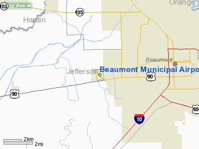
Beaumont Municipal Airport (IATA: BMT, ICAO: KBMT) is an airport located six miles west of Beaumont, Texas. The airport has two runways.
The airport is used solely for general aviation purposes.
Pop culture references
- Comedian Ron White mentions and satirizes Beaumont Municipal Airport by saying this:
"We took off from the Beaumont Airport, hair care, and tire center", indicating that the airport is very small and similar to a Supercenter or a strip mall. The airport is owned by Melanie Meriwether of Beaumont, Texas.
The above content comes from Wikipedia and is published under free licenses – click here to read more.
Location & QuickFacts
| FAA Information Effective: | 2008-09-25 |
| Airport Identifier: | BMT |
| Airport Status: | Operational |
| Longitude/Latitude: | 094-12-54.3482W/30-04-12.7358N
-94.215097/30.070204 (Estimated) |
| Elevation: | 32 ft / 9.75 m (Surveyed) |
| Land: | 276 acres |
| From nearest city: | 6 nautical miles W of Beaumont, TX |
| Location: | Jefferson County, TX |
| Magnetic Variation: | 04E (2000) |
Owner & Manager
| Ownership: | Publicly owned |
| Owner: | City Of Beaumont |
| Address: | Po Box 3827
Beaumont, TX 77704 |
| Phone number: | 409-880-3742 |
| Manager: | Brenda Beadle |
| Address: | Box 3827
Beaumont, TX 77704-3827 |
| Phone number: | 409-880-3718 |
Airport Operations and Facilities
| Airport Use: | Open to public |
| Wind indicator: | Yes |
| Segmented Circle: | Yes |
| Control Tower: | No |
| Lighting Schedule: | DUSK-DAWN
MIRL RY 13/31 PRESET LOW INTST; TO INCR INTST ACTVT - CTAF. |
| Beacon Color: | Clear-Green (lighted land airport) |
| Landing fee charge: | No |
| Sectional chart: | Houston |
| Region: | ASW - Southwest |
| Boundary ARTCC: | ZHU - Houston |
| Tie-in FSS: | CXO - Montgomery County |
| FSS on Airport: | No |
| FSS Toll Free: | 1-800-WX-BRIEF |
| NOTAMs Facility: | CXO (NOTAM-d service avaliable) |
| Federal Agreements: | NGY |
Airport Communications
| CTAF: | 123.000 |
| Unicom: | 123.000 |
Airport Services
| Fuel available: | 100LLA
100LL AVBL 24 HRS SELF SERVICE WITH CREDIT CARD. |
| Airframe Repair: | MAJOR |
| Power Plant Repair: | MAJOR |
| Bulk Oxygen: | NONE |
Runway Information
Runway 13/31
| Dimension: | 4001 x 75 ft / 1219.5 x 22.9 m |
| Surface: | ASPH, Good Condition |
| Weight Limit: | Single wheel: 17000 lbs. |
| Edge Lights: | Medium |
| |
Runway 13 |
Runway 31 |
| Longitude: | 094-13-13.8835W | 094-12-40.2185W |
| Latitude: | 30-04-27.8058N | 30-04-01.1414N |
| Elevation: | 29.00 ft | 31.00 ft |
| Alignment: | 127 | 127 |
| Traffic Pattern: | Right | Left |
| Markings: | Non-precision instrument, Good Condition | Non-precision instrument, Good Condition |
| Crossing Height: | 41.00 ft | 30.00 ft |
| Displaced threshold: | 332.00 ft | 67.00 ft |
| VASI: | pulsating/steady burning on left side | pulsating/steady burning on left side |
| Visual Glide Angle: | 3.00° | 4.00° |
| Runway End Identifier: | Yes | |
| Obstruction: | 35 ft tree, 660.0 ft from runway, 158 ft left of centerline, 13:1 slope to clear
APCH SLOPE 18:1 TO DSPLCD THLD; 45 FT TREE 835 FT FROM DSPLCD THLD 300 FT LEFT OF EXTDD CNTRLN. | 44 ft trees, 846.0 ft from runway, 205 ft right of centerline, 14:1 slope to clear
APCH SLOPE 20:1 TO DSPLCD THLD; 44 FT TREES 913 FT FROM DSPLCD THLD 205 FT RIGHT OF EXTDD CNTRLN. |
|
Runway 16/34
| Dimension: | 2050 x 75 ft / 624.8 x 22.9 m |
| Surface: | TURF, Good Condition |
| |
Runway 16 |
Runway 34 |
| Longitude: | 094-12-51.3524W | 094-12-46.7936W |
| Latitude: | 30-04-19.2946N | 30-03-59.3939N |
| Elevation: | 30.00 ft | 30.00 ft |
| Alignment: | 127 | 127 |
| Traffic Pattern: | Right | Left |
| Obstruction: | 61 ft trees, 1390.0 ft from runway, 200 ft right of centerline, 22:1 slope to clear | 65 ft trees, 1374.0 ft from runway, 21:1 slope to clear |
|
Radio Navigation Aids
| ID |
Type |
Name |
Ch |
Freq |
Var |
Dist |
| GDE | NDB | Goodhue | | 368.00 | 07E | 0.7 nm |
| HRD | NDB | Hardin County | | 524.00 | 04E | 16.2 nm |
| ORG | NDB | Orange | | 211.00 | 05E | 21.9 nm |
| CBC | NDB | Anahuac | | 413.00 | 05E | 29.4 nm |
| UX | NDB | Sulfy | | 278.00 | 04E | 42.0 nm |
| DQU | NDB | De Quincy | | 410.00 | 05E | 44.6 nm |
| BPT | VOR/DME | Beaumont | 092X | 114.50 | 07E | 12.8 nm |
| SBI | VOR/DME | Sabine Pass | 101X | 115.40 | 07E | 24.8 nm |
| MHF | VOR/DME | Trinity | 083X | 113.60 | 07E | 42.0 nm |
| DAS | VORTAC | Daisetta | 116X | 116.90 | 05E | 23.5 nm |
Remarks
Images and information placed above are from
http://www.airport-data.com/airport/BMT/
We thank them for the data!
| General Info
|
| Country |
United States
|
| State |
TEXAS
|
| FAA ID |
BMT
|
| Latitude |
30-04-14.472N
|
| Longitude |
094-12-57.053W
|
| Elevation |
32 feet
|
| Near City |
BEAUMONT
|
We don't guarantee the information is fresh and accurate. The data may
be wrong or outdated.
For more up-to-date information please refer to other sources.
|
|


