 |
|
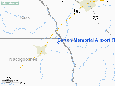
Location & QuickFacts
| FAA Information Effective: | 2008-09-25 |
| Airport Identifier: | TS51 |
| Airport Status: | Operational |
| Longitude/Latitude: | 094-27-33.7370W/31-50-13.6220N
-94.459371/31.837117 (Estimated) |
| Elevation: | 345 ft / 105.16 m (Estimated) |
| Land: | 60 acres |
| From nearest city: | 2 nautical miles NE of Garrison, TX |
| Location: | Nacogdoches County, TX |
| Magnetic Variation: | 05E (1985) |
Owner & Manager
| Ownership: | Privately owned |
| Owner: | Bob Barton |
| Address: | Po Box 540
Garrison, TX 75946-0540 |
| Phone number: | 409-347-2744 |
| Manager: | Carl Adams |
| Address: | Rt 3, Box 242 C-1
Timpson, TX 75975 |
| Phone number: | 409-254-2242 |
Airport Operations and Facilities
| Airport Use: | Private |
| Wind indicator: | No |
| Segmented Circle: | No |
| Control Tower: | No |
| Landing fee charge: | No |
| Sectional chart: | Houston |
| Region: | ASW - Southwest |
| Boundary ARTCC: | ZFW - Fort Worth |
| Tie-in FSS: | CXO - Montgomery County |
| FSS on Airport: | No |
| FSS Toll Free: | 1-800-WX-BRIEF
FOR FP FILING CALL CXO FSS 1-800-833-5602. |
Runway Information
Runway 04/22
| Dimension: | 2550 x 40 ft / 777.2 x 12.2 m |
| Surface: | TURF, Poor Condition |
| |
Runway 04 |
Runway 22 |
| Traffic Pattern: | Left | Left |
| Obstruction: | 15 ft trees | 40 ft trees, 0.0 ft from runway, 95 ft left of centerline |
|
Radio Navigation Aids
| ID |
Type |
Name |
Ch |
Freq |
Var |
Dist |
| CZJ | NDB | Amason | | 341.00 | 04E | 15.6 nm |
| GXD | NDB | Nacogdoches | | 391.00 | 05E | 16.9 nm |
| RPF | NDB | Carthage | | 332.00 | 04E | 22.2 nm |
| OC | NDB | Nados | | 253.00 | 05E | 25.0 nm |
| HNO | NDB | Henderson | | 371.00 | 06E | 29.4 nm |
| MSD | NDB | Mansfield | | 414.00 | 04E | 38.0 nm |
| JSO | NDB | Cherokee County | | 263.00 | 05E | 38.7 nm |
| MMY | NDB | Many | | 272.00 | 04E | 49.6 nm |
| GGG | VORTAC | Gregg County | 070X | 112.30 | 07E | 38.0 nm |
| LFK | VORTAC | Lufkin | 058X | 112.10 | 05E | 42.7 nm |
Remarks
- RWY SFC IREG; PRIM SFC IREG; 8' DROP 25' WEST OF CNTRLN 500' FROM NE THR.
- USE EXTREME CAUTION LIVESTOCK AND DEER OCNLY ON RY.
- USE EXTREME CAUTION 1' STEEL REBAR ON RY EDGES EVERY 200'.
Images and information placed above are from
http://www.airport-data.com/airport/TS51/
We thank them for the data!
| General Info
|
| Country |
United States
|
| State |
TEXAS
|
| FAA ID |
TS51
|
| Latitude |
31-50-13.622N
|
| Longitude |
094-27-33.737W
|
| Elevation |
345 feet
|
| Near City |
GARRISON
|
We don't guarantee the information is fresh and accurate. The data may
be wrong or outdated.
For more up-to-date information please refer to other sources.
|
|


