 |
|
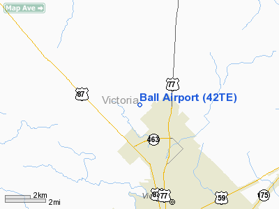
Location & QuickFacts
| FAA Information Effective: | 2008-09-25 |
| Airport Identifier: | 42TE |
| Airport Status: | Operational |
| Longitude/Latitude: | 097-01-15.9530W/28-53-15.9490N
-97.021098/28.887764 (Estimated) |
| Elevation: | 124 ft / 37.80 m (Estimated) |
| Land: | 170 acres |
| From nearest city: | 5 nautical miles N of Victoria, TX |
| Location: | Victoria County, TX |
| Magnetic Variation: | 07E (1985) |
Owner & Manager
| Ownership: | Privately owned |
| Owner: | Warren Ball |
| Address: | 404 Ball Arpt Rd
Victoria, TX 77904 |
| Phone number: | 512-575-1851 |
| Manager: | A.w. Kenne |
| Address: | 404 Ball Arpt Rd
Victoria, TX 77904 |
| Phone number: | 512-575-6030 |
Airport Operations and Facilities
| Airport Use: | Private |
| Wind indicator: | Yes |
| Segmented Circle: | No |
| Control Tower: | No |
| Landing fee charge: | No |
| Sectional chart: | San Antonio |
| Region: | ASW - Southwest |
| Boundary ARTCC: | ZHU - Houston |
| Tie-in FSS: | CXO - Montgomery County |
| FSS on Airport: | No |
| FSS Toll Free: | 1-800-WX-BRIEF
FOR FP FILING CALL CXO FSS 1-800-992-7433. |
Airport Services
| Fuel available: | 100LLMOGAS |
| Bottled Oxygen: | NONE |
| Bulk Oxygen: | NONE |
Runway Information
Runway 14/32
| Dimension: | 2370 x 80 ft / 722.4 x 24.4 m |
| Surface: | TURF, Good Condition |
| |
Runway 14 |
Runway 32 |
| Traffic Pattern: | Left | Left |
| Obstruction: | 4 ft fence | 4 ft fence, 0.0 ft from runway |
|
Runway 17/35
| Dimension: | 2500 x 65 ft / 762.0 x 19.8 m |
| Surface: | TURF, Good Condition |
| |
Runway 17 |
Runway 35 |
| Traffic Pattern: | Left | Left |
| Obstruction: | 4 ft fence | 4 ft fence, 0.0 ft from runway |
|
Radio Navigation Aids
| ID |
Type |
Name |
Ch |
Freq |
Var |
Dist |
| PKV | NDB | Port Lavaca | | 515.00 | 05E | 22.9 nm |
| OKT | NDB | Yoakum | | 350.00 | 06E | 26.2 nm |
| MNO | NDB | Mellon Ranch | | 375.00 | 06E | 37.8 nm |
| RKP | NDB | Rockport | | 391.00 | 06E | 47.9 nm |
| VCT | VOR/DME | Victoria | 027X | 109.00 | 06E | 2.3 nm |
| PSX | VORTAC | Palacios | 120X | 117.30 | 08E | 38.4 nm |
Remarks
- RYS 14/32 & 17/35 SOFT WHEN WET.
- +4' FENCE BORDERS BOTH RWYS.
- LNDG RWY 14/TKOF RWY 32. IN HIGH WIND CONDITIONS LANDINGS ON RWY 32 AUTHORIZED.
- PRE DATES THE ACT.
Images and information placed above are from
http://www.airport-data.com/airport/42TE/
We thank them for the data!
| General Info
|
| Country |
United States
|
| State |
TEXAS
|
| FAA ID |
42TE
|
| Latitude |
28-53-15.949N
|
| Longitude |
097-01-15.953W
|
| Elevation |
124 feet
|
| Near City |
VICTORIA
|
We don't guarantee the information is fresh and accurate. The data may
be wrong or outdated.
For more up-to-date information please refer to other sources.
|
|


