 |
|
Location & QuickFacts
| FAA Information Effective: | 2008-09-25 |
| Airport Identifier: | 20TS |
| Airport Status: | Operational |
| Longitude/Latitude: | 099-04-05.1290W/29-48-35.7960N
-99.068091/29.809943 (Estimated) |
| Elevation: | 1420 ft / 432.82 m (Estimated) |
| Land: | 20 acres |
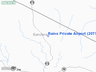
| From nearest city: | 5 nautical miles S of Bandera, TX |
| Location: | Bandera County, TX |
| Magnetic Variation: | 07E (1985) |
Owner & Manager
| Ownership: | Privately owned |
| Owner: | Les Bains |
| Address: | Hcr 3 Box 506
Bandera, TX 78003 |
| Phone number: | 512-796-3570 |
| Manager: | Les Bains |
| Address: | Hcr 3 Box 506
Bandera, TX 78003 |
| Phone number: | 512-796-3570 |
Airport Operations and Facilities
| Airport Use: | Private |
| Wind indicator: | Yes |
| Segmented Circle: | No |
| Control Tower: | No |
| Sectional chart: | San Antonio |
| Region: | ASW - Southwest |
| Boundary ARTCC: | ZHU - Houston |
| Tie-in FSS: | SJT - San Angelo |
| FSS Toll Free: | 1-800-WX-BRIEF |
Runway Information
Runway 03/21
| Dimension: | 1900 x 50 ft / 579.1 x 15.2 m |
| Surface: | DIRT-TURF,
DIRT-TURF |
| |
Runway 03 |
Runway 21 |
| Traffic Pattern: | Left | Left |
| Obstruction: | 20 ft pline, 75.0 ft from runway | |
|
Radio Navigation Aids
| ID |
Type |
Name |
Ch |
Freq |
Var |
Dist |
| ER | NDB | Shein | | 263.00 | 08E | 7.0 nm |
| HMA | NDB | Hondo | | 329.00 | 08E | 26.8 nm |
| CVB | NDB | Castroville | | 338.00 | 08E | 30.1 nm |
| HHH | NDB | Devine | | 359.00 | 07E | 40.9 nm |
| KSY | TACAN | Kelly | 057X | | 07E | 35.8 nm |
| DHK | TACAN | Randolph | 036X | | 09E | 44.9 nm |
| SSF | VOR | Stinson | | 108.40 | 09E | 46.5 nm |
| HDO | VOR/DME | Hondo | 31X | 109.40 | 08E | 28.3 nm |
| CSI | VORTAC | Center Point | 122X | 117.50 | 08E | 10.2 nm |
| STV | VORTAC | Stonewall | 085X | 113.80 | 08E | 30.4 nm |
| SAT | VORTAC | San Antonio | 115X | 116.80 | 08E | 33.2 nm |
| RND | VORTAC | Randolph | 70X | 112.30 | 09E | 44.5 nm |
| SAT | VOT | San Antonio Intl | | 110.40 | | 35.4 nm |
Images and information placed above are from
http://www.airport-data.com/airport/20TS/
We thank them for the data!
| General Info
|
| Country |
United States
|
| State |
TEXAS
|
| FAA ID |
20TS
|
| Latitude |
29-48-35.796N
|
| Longitude |
099-04-05.129W
|
| Elevation |
1420 feet
|
| Near City |
BANDERA
|
We don't guarantee the information is fresh and accurate. The data may
be wrong or outdated.
For more up-to-date information please refer to other sources.
|
|


