 |
|
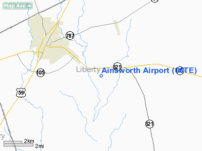
Location & QuickFacts
| FAA Information Effective: | 2008-09-25 |
| Airport Identifier: | 06TE |
| Airport Status: | Operational |
| Longitude/Latitude: | 095-01-36.7520W/30-18-45.7540N
-95.026876/30.312709 (Estimated) |
| Elevation: | 129 ft / 39.32 m (Estimated) |
| Land: | 150 acres |
| From nearest city: | 3 nautical miles SE of Cleveland, TX |
| Location: | Liberty County, TX |
| Magnetic Variation: | 06E (1985) |
Owner & Manager
| Ownership: | Privately owned |
| Owner: | John J. Ainsworth |
| Address: | 120 Andrew Lane
Porter, TX 77365 |
| Phone number: | 713-354-5000 |
| Manager: | John J. Ainsworth |
| Address: | 120 Andrew Lane
Porter, TX 77365 |
| Phone number: | 713-358-5910 |
Airport Operations and Facilities
| Airport Use: | Private |
| Wind indicator: | Yes |
| Segmented Circle: | No |
| Control Tower: | No |
| Sectional chart: | Houston |
| Region: | ASW - Southwest |
| Boundary ARTCC: | ZHU - Houston |
| Tie-in FSS: | CXO - Montgomery County |
| FSS on Airport: | No |
| FSS Toll Free: | 1-800-WX-BRIEF
FOR FP FILING CALL CXO FSS 1-800-833-5602. |
Runway Information
Runway 08/26
| Dimension: | 3500 x 50 ft / 1066.8 x 15.2 m |
| Surface: | ASPH, |
| |
Runway 08 |
Runway 26 |
| Traffic Pattern: | Left | Left |
|
Radio Navigation Aids
| ID |
Type |
Name |
Ch |
Freq |
Var |
Dist |
| BVP | NDB | Nixin | | 326.00 | 05E | 21.5 nm |
| DWH | NDB | David Hooks | | 521.00 | 05E | 30.2 nm |
| CBC | NDB | Anahuac | | 413.00 | 05E | 37.6 nm |
| JPA | NDB | Sanjac | | 347.00 | 05E | 38.8 nm |
| UTS | NDB | Huntsville | | 308.00 | 06E | 38.9 nm |
| EYQ | NDB | Weiser | | 286.00 | 06E | 39.2 nm |
| HRD | NDB | Hardin County | | 524.00 | 04E | 39.8 nm |
| LYD | NDB | Lakeside | | 249.00 | 05E | 45.1 nm |
| GDE | NDB | Goodhue | | 368.00 | 07E | 45.3 nm |
| EFD | TACAN | Ellington | 031X | | 05E | 43.0 nm |
| HUB | VOR/DME | Hobby | 118X | 117.10 | 05E | 41.6 nm |
| MHF | VOR/DME | Trinity | 083X | 113.60 | 07E | 48.3 nm |
| DAS | VORTAC | Daisetta | 116X | 116.90 | 05E | 21.2 nm |
| IAH | VORTAC | Humble | 113X | 116.60 | 05E | 27.1 nm |
| HOU | VOT | Houston Wm P Hobby | | 108.40 | | 42.2 nm |
Remarks
- REQ'D TPA 500'AGL ON S.SIDE OF ARPT.
Images and information placed above are from
http://www.airport-data.com/airport/06TE/
We thank them for the data!
| General Info
|
| Country |
United States
|
| State |
TEXAS
|
| FAA ID |
06TE
|
| Latitude |
30-18-45.754N
|
| Longitude |
095-01-36.752W
|
| Elevation |
129 feet
|
| Near City |
CLEVELAND
|
We don't guarantee the information is fresh and accurate. The data may
be wrong or outdated.
For more up-to-date information please refer to other sources.
|
|


