 |
|
| Winchester Municipal Airport |
| IATA: none – ICAO: KBGF – FAA LID: BGF |
| Summary |
| Airport type |
Public |
| Owner |
City of Winchester |
| Serves |
Winchester, Tennessee |
| Elevation AMSL |
979 ft / 298 m |
| Coordinates |
35°10′39″N 086°03′58″W / 35.1775°N 86.06611°W / 35.1775; -86.06611 |
| Website |
winchester-airport.com |
| Runways |
| Direction |
Length |
Surface |
| ft |
m |
| 18/36 |
5,002 |
1,525 |
Asphalt |
| Statistics (2008) |
| Aircraft operations |
5,200 |
| Based aircraft |
28 |
| Source: Federal Aviation Administration |
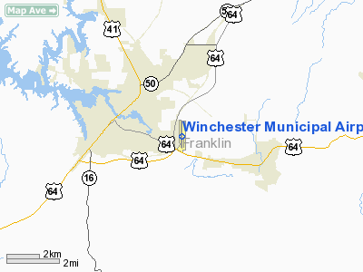
Winchester Municipal Airport (ICAO: KBGF, FAA LID: BGF) is a city-owned public-use airport located three nautical miles (6 km) southeast of the central business district of Winchester, a city in Franklin County, Tennessee, United States.
Although most U.S. airports use the same three-letter location identifier for the FAA and IATA, this airport is assigned BGF by the FAA but has no designation from the IATA (which assigned BGF to Bangui M'Poko International Airport in Bangui, Central African Republic).
Facilities and aircraft
Winchester Municipal Airport covers an area of 134 acres (54 ha) at an elevation of 979 feet (298 m) above mean sea level. It has one asphalt paved runway designated 18/36 which measures 5,002 by 75 feet (1,525 x 23 m).
For the 12-month period ending June 30, 2008, the airport had 5,200 aircraft operations, an average of 14 per day: 92% general aviation, 5% air taxi and 3% military. At that time there were 28 aircraft based at this airport: 75% single-engine, 18% multi-engine and 7% jet.
The above content comes from Wikipedia and is published under free licenses – click here to read more.
Location & QuickFacts
| FAA Information Effective: | 2008-09-25 |
| Airport Identifier: | BGF |
| Airport Status: | Operational |
| Longitude/Latitude: | 086-03-58.2000W/35-10-39.1000N
-86.066167/35.177528 (Estimated) |
| Elevation: | 979 ft / 298.40 m (Surveyed) |
| Land: | 134 acres |
| From nearest city: | 3 nautical miles SE of Winchester, TN |
| Location: | Franklin County, TN |
| Magnetic Variation: | 02W (1995) |
Owner & Manager
| Ownership: | Publicly owned |
| Owner: | City Of Winchester |
| Address: | City Hall
Winchester, TN 37398 |
| Phone number: | 931-967-4771 |
| Manager: | Jason Wafford |
| Address: | 574 Aviation Dr
Winchester, TN 37398 |
| Phone number: | 931-967-3148 |
Airport Operations and Facilities
| Airport Use: | Open to public |
| Wind indicator: | Yes |
| Segmented Circle: | Yes |
| Control Tower: | No |
| Lighting Schedule: | DUSK-DAWN |
| Beacon Color: | Clear-Green (lighted land airport) |
| Landing fee charge: | No |
| Sectional chart: | Atlanta |
| Region: | ASO - Southern |
| Boundary ARTCC: | ZME - Memphis |
| Tie-in FSS: | BNA - Nashville |
| FSS on Airport: | No |
| FSS Toll Free: | 1-800-WX-BRIEF |
| NOTAMs Facility: | BNA (NOTAM-d service avaliable) |
| Federal Agreements: | NGY |
Airport Communications
| CTAF: | 122.800 |
| Unicom: | 122.800
UNICOM MONITORED IREGLY. |
Airport Services
| Fuel available: | 100LLA |
| Airframe Repair: | MAJOR |
| Power Plant Repair: | MAJOR |
| Bottled Oxygen: | NONE |
| Bulk Oxygen: | NONE |
Runway Information
Runway 18/36
| Dimension: | 5002 x 75 ft / 1524.6 x 22.9 m |
| Surface: | ASPH, Good Condition |
| Weight Limit: | Single wheel: 30000 lbs.
Dual wheel: 42000 lbs. |
| Edge Lights: | Medium |
| |
Runway 18 |
Runway 36 |
| Longitude: | 086-03-57.2993W | 086-03-59.1011W |
| Latitude: | 35-11-03.8460N | 35-10-14.3954N |
| Elevation: | 971.00 ft | 975.00 ft |
| Alignment: | 127 | 2 |
| Traffic Pattern: | Left | Left |
| Markings: | Basic, Good Condition | Basic, Good Condition |
| Crossing Height: | 80.00 ft | 80.00 ft |
| VASI: | 2-light PAPI on left side | 2-light PAPI on left side |
| Visual Glide Angle: | 3.00° | 3.50° |
| Runway End Identifier: | Yes | Yes |
| Obstruction: | 117 ft trees, 2916.0 ft from runway, 73 ft left of centerline, 23:1 slope to clear | 70 ft trees, 1296.0 ft from runway, 117 ft left of centerline, 15:1 slope to clear |
|
Radio Navigation Aids
| ID |
Type |
Name |
Ch |
Freq |
Var |
Dist |
| SYI | FAN MARKER | Bomar | | | 01W | 26.9 nm |
| BGF | NDB | Boiling Fork | | 263.00 | 02W | 0.1 nm |
| UOS | NDB | Sewanee | | 275.00 | 02E | 8.5 nm |
| ULH | NDB | Burwi | | 332.00 | 03W | 19.1 nm |
| TNY | NDB | Kelso | | 358.00 | 01W | 23.5 nm |
| APT | NDB | Jasper | | 382.00 | 02W | 24.7 nm |
| RN | NDB | Warri | | 209.00 | 02W | 37.6 nm |
| LUG | NDB | Verona | | 251.00 | 00W | 41.3 nm |
| HUA | NDB | Redstone | | 287.00 | 00W | 42.0 nm |
| CWH | NDB | Capshaw | | 350.00 | 01W | 42.7 nm |
| FTP | NDB | Fort Payne | | 426.00 | 01W | 44.0 nm |
| CQN | NDB | Daisy | | 341.00 | 02W | 44.7 nm |
| GZS | NDB | Giles/dcmsnd | | 375.00 | 00E | 48.8 nm |
| FQW | NDB | Walter Hill | | 371.00 | 02W | 49.4 nm |
| UXM | VOR | Tullahoma Regional | | 109.65 | 03W | 15.0 nm |
| SYI | VOR/DME | Shelbyville | 027X | 109.00 | 01W | 29.5 nm |
| RQZ | VORTAC | Rocket | 059X | 112.20 | 02E | 36.1 nm |
| GQO | VORTAC | Choo Choo | 105X | 115.80 | 01E | 46.7 nm |
| HSV | VOT | Huntsville | | 111.00 | | 36.7 nm |
Remarks
- HEAVY NON-RADIO EQUIPPED TFC FIRST SAT OF EACH MONTH.
Images and information placed above are from
http://www.airport-data.com/airport/BGF/
We thank them for the data!
| General Info
|
| Country |
United States
|
| State |
TENNESSEE
|
| FAA ID |
BGF
|
| Latitude |
35-10-39.123N
|
| Longitude |
086-03-58.202W
|
| Elevation |
979 feet
|
| Near City |
WINCHESTER
|
We don't guarantee the information is fresh and accurate. The data may
be wrong or outdated.
For more up-to-date information please refer to other sources.
|
|


