|
|
William L. Whitehurst Field Airport |
| William L. Whitehurst Field |
 |
| IATA: none – ICAO: none – FAA LID: M08 |
| Summary |
| Airport type |
Public |
| Owner |
Hardeman County |
| Serves |
Bolivar, Tennessee |
| Elevation AMSL |
499 ft / 152 m |
| Coordinates |
35°12′52″N 089°02′36″W / 35.21444°N 89.04333°W / 35.21444; -89.04333 |
| Runways |
| Direction |
Length |
Surface |
| ft |
m |
| 1/19 |
4,004 |
1,220 |
Asphalt |
| Statistics (2000) |
| Aircraft operations |
4,440 |
| Source: Federal Aviation Administration |
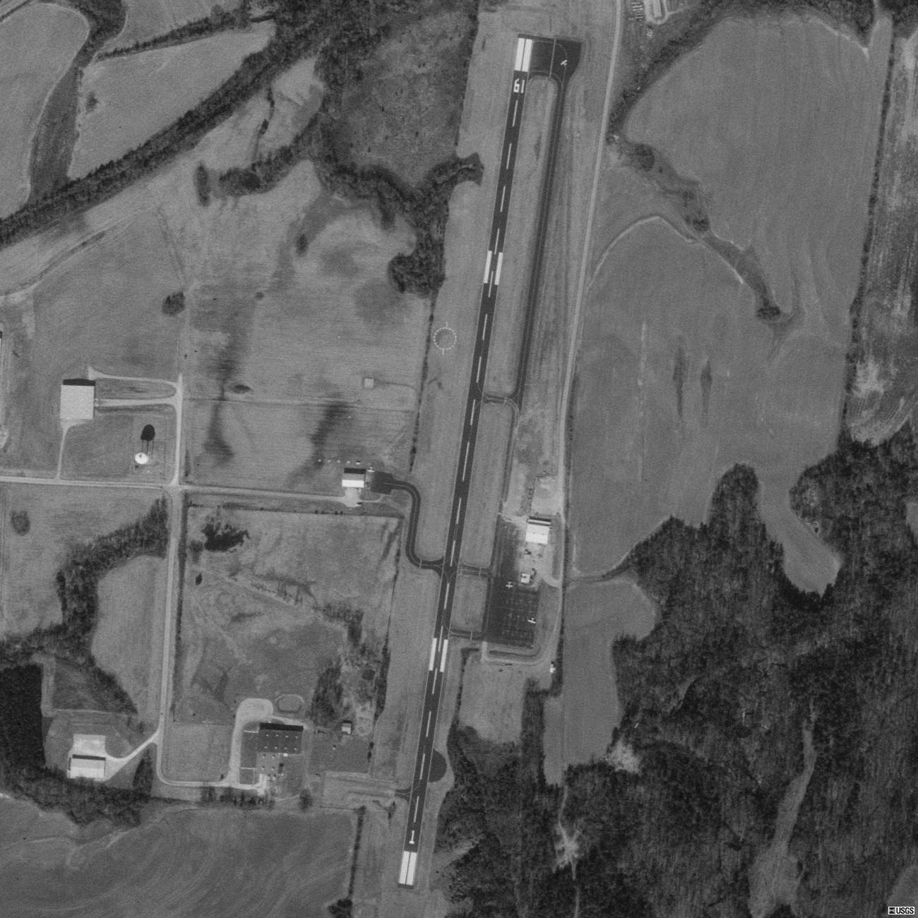
William L. Whitehurst Field (FAA LID: M08) is a county-owned, public-use airport located four nautical miles (7 km) southwest of the central business district of Bolivar, a city in Hardeman County, Tennessee, United States. Facilities and aircraft
William L. Whitehurst Field covers an area of 85 acres (34 ha) at an elevation of 499 feet (152 m) above mean sea level. It has one runway designated 1/19 with a 4,004 by 75 ft (1,220 by 23 m) asphalt surface. For the 12-month period ending March 14, 2000, the airport had 4,440 aircraft operations, an average of 12 per day: 91% general aviation and 9% air taxi.
The airport is attended from 0830 to 1700 local time and has 100LL aviation fuel available. It is included under the McKellar-Sipes Regional Airport FSS. It has medium intensity runway lighting and VASI on both runways. NOTAMs are filed with McKellar-Sipes Regional Airport.
The above content comes from Wikipedia and is published under free licenses – click here to read more.

Location & QuickFacts
| FAA Information Effective: | 2008-09-25 |
| Airport Identifier: | M08 |
| Airport Status: | Operational |
| Longitude/Latitude: | 089-02-36.1040W/35-12-52.0540N
-89.043362/35.214459 (Estimated) |
| Elevation: | 499 ft / 152.10 m (Surveyed) |
| Land: | 85 acres |
| From nearest city: | 4 nautical miles SW of Bolivar, TN |
| Location: | Hardeman County, TN |
| Magnetic Variation: | 01E (1990) |
Owner & Manager
| Ownership: | Publicly owned |
| Owner: | Hardeman County
& CITY OF BOLIVAR. |
| Address: | Box 250
Bolivar, TN 38009 |
| Phone number: | 731-658-3266 |
| Manager: | Dave Perrin |
| Address: | 800arpt Rd
Bolivar, TN 38008 |
| Phone number: | 731-658-7556
NIGHT PHONE 731-658-5902. |
Airport Operations and Facilities
| Airport Use: | Open to public |
| Wind indicator: | Yes |
| Segmented Circle: | Yes |
| Control Tower: | No |
| Lighting Schedule: | DUSK-DAWN |
| Landing fee charge: | No |
| Sectional chart: | Memphis |
| Region: | ASO - Southern |
| Boundary ARTCC: | ZME - Memphis |
| Tie-in FSS: | MKL - Jackson |
| FSS on Airport: | No |
| FSS Toll Free: | 1-800-WX-BRIEF |
| NOTAMs Facility: | MKL (NOTAM-d service avaliable) |
| Federal Agreements: | NGY |
Airport Communications
| CTAF: | 123.000 |
| Unicom: | 123.000 |
Airport Services
| Fuel available: | 100LL |
| Airframe Repair: | MAJOR |
| Power Plant Repair: | MAJOR |
| Bottled Oxygen: | NONE |
| Bulk Oxygen: | NONE |
Runway Information
Runway 01/19
| Dimension: | 4004 x 75 ft / 1220.4 x 22.9 m |
| Surface: | ASPH, Good Condition |
| Edge Lights: | Medium |
| |
Runway 01 |
Runway 19 |
| Longitude: | 089-02-38.9970W | 089-02-33.2090W |
| Latitude: | 35-12-32.3960N | 35-13-11.7120N |
| Elevation: | 499.00 ft | 490.00 ft |
| Alignment: | 7 | 127 |
| Traffic Pattern: | Left | Left |
| Markings: | Non-precision instrument, Good Condition | Non-precision instrument, Good Condition |
| Crossing Height: | 26.00 ft | 22.00 ft |
| VASI: | 2-box SAVASI on left side | 2-box SAVASI on left side |
| Obstruction: | 67 ft trees, 1818.0 ft from runway, 131 ft left of centerline, 24:1 slope to clear | 71 ft trees, 1551.0 ft from runway, 87 ft left of centerline, 19:1 slope to clear |
|
Radio Navigation Aids
| ID |
Type |
Name |
Ch |
Freq |
Var |
Dist |
| FYE | NDB | Somerville | | 255.00 | 00E | 17.2 nm |
| SZY | NDB | Sibley | | 386.00 | 01E | 25.9 nm |
| COO | NDB | Covington | | 326.00 | 02E | 34.9 nm |
| OLV | NDB | Olive Branch | | 275.00 | 01E | 39.3 nm |
| HHY | NDB | Pinhook | | 346.00 | 01W | 41.3 nm |
| MIG | NDB | Millington | | 232.00 | 04E | 43.8 nm |
| TGC | NDB | Gibson | | 378.00 | 01E | 44.3 nm |
| SPQ | NDB | Spain | | 414.00 | 04E | 49.5 nm |
| MKL | VOR/DME | Mc Kellar | 057X | 112.00 | 02E | 24.3 nm |
| JKS | VOR/DME | Jacks Creek | 031X | 109.40 | 02E | 40.7 nm |
| HLI | VORTAC | Holly Springs | 071X | 112.40 | 03E | 34.8 nm |
| MEM | VORTAC | Memphis | 122X | 117.50 | 01E | 47.7 nm |
| MEM | VOT | Memphis Metropolitn | | 111.00 | | 47.0 nm |
Remarks
Images and information placed above are from
http://www.airport-data.com/airport/M08/
We thank them for the data!
| General Info
|
| Country |
United States
|
| State |
TENNESSEE
|
| FAA ID |
M08
|
| Latitude |
35-12-52.054N
|
| Longitude |
089-02-36.104W
|
| Elevation |
499 feet
|
| Near City |
BOLIVAR
|
We don't guarantee the information is fresh and accurate. The data may
be wrong or outdated.
For more up-to-date information please refer to other sources.
|
|