 |
|
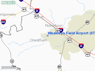
Location & QuickFacts
| FAA Information Effective: | 2008-09-25 |
| Airport Identifier: | 6TN1 |
| Airport Status: | Operational |
| Longitude/Latitude: | 087-04-56.0000W/36-24-19.0000N
-87.082222/36.405278 (Estimated) |
| Elevation: | 705 ft / 214.88 m (Estimated) |
| Land: | 4 acres |
| From nearest city: | 2 nautical miles W of Pleasantview, TN |
| Location: | Cheatham County, TN |
| Magnetic Variation: | 01W (1990) |
Owner & Manager
| Ownership: | Privately owned |
| Owner: | Byron Dale Weakley |
| Address: | 1255 Oaklawn Road
Chapmansboro, TN 37035 |
| Phone number: | 615-746-5236 |
| Manager: | Byron Dale Weakley |
| Address: | 1255 Oaklawn Road
Chapmansboro, TN 37035 |
| Phone number: | 615-746-5236 |
Airport Operations and Facilities
| Airport Use: | Private |
| Wind indicator: | Yes |
| Segmented Circle: | No |
| Control Tower: | No |
| Sectional chart: | St Louis |
| Region: | ASO - Southern |
| Boundary ARTCC: | ZME - Memphis |
| Tie-in FSS: | BNA - Nashville |
| FSS on Airport: | No |
| FSS Toll Free: | 1-800-WX-BRIEF |
Runway Information
Runway 18/36
| Dimension: | 3370 x 60 ft / 1027.2 x 18.3 m |
| Surface: | TURF, |
| |
Runway 18 |
Runway 36 |
| Traffic Pattern: | Left | Left |
| Markings: | Nonstandard,
MKD WITH WHITE REFLECTORS EVERY 200 FT. | , |
| Displaced threshold: | 300.00 ft | 0.00 ft |
| Obstruction: | 15 ft road, 20.0 ft from runway | |
|
Radio Navigation Aids
| ID |
Type |
Name |
Ch |
Freq |
Var |
Dist |
| ON | NDB | Music | | 279.00 | 03W | 5.0 nm |
| PED | NDB | Needmore | | 221.00 | 01W | 11.2 nm |
| DMZ | NDB | Dickson | | 203.00 | 01W | 23.8 nm |
| VI | NDB | Opery | | 344.00 | 02W | 24.1 nm |
| FK | NDB | Airbe | | 273.00 | 01W | 25.6 nm |
| HIX | NDB | Honey Grove | | 356.00 | 01W | 31.1 nm |
| AEY | NDB | Waverly | | 329.00 | 00E | 36.4 nm |
| JUE | NDB | Lebanon | | 414.00 | 02W | 39.4 nm |
| SWZ | NDB | Sewart | | 391.00 | 02W | 40.3 nm |
| FQW | NDB | Walter Hill | | 371.00 | 02W | 43.6 nm |
| PBC | NDB | Maury County | | 365.00 | 01W | 47.9 nm |
| GMH | NDB | Muhlenberg | | 362.00 | 01E | 49.5 nm |
| LFB | NDB | Lafayette | | 245.00 | 02W | 49.8 nm |
| HXW | TACAN | Screaming Eagle | 096X | | 01W | 25.7 nm |
| CKV | VOR/DME | Clarksville | 043X | 110.60 | 01W | 20.6 nm |
| BNA | VORTAC | Nashville | 088X | 114.10 | 02W | 25.1 nm |
| GHM | VORTAC | Graham | 053X | 111.60 | 03E | 38.7 nm |
| BWG | VORTAC | Bowling Green | 126X | 117.90 | 02E | 44.0 nm |
| BNA | VOT | Nashville Metropoln | | 108.60 | | 25.6 nm |
| MQY | VOT | Smyrna | | 110.20 | | 36.7 nm |
Remarks
Images and information placed above are from
http://www.airport-data.com/airport/6TN1/
We thank them for the data!
| General Info
|
| Country |
United States
|
| State |
TENNESSEE
|
| FAA ID |
6TN1
|
| Latitude |
36-24-22.178N
|
| Longitude |
087-04-56.009W
|
| Elevation |
720 feet
|
| Near City |
PLEASANTVIEW
|
We don't guarantee the information is fresh and accurate. The data may
be wrong or outdated.
For more up-to-date information please refer to other sources.
|
|


