 |
|
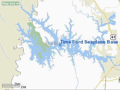
Tims Ford Seaplane Base Airport |
Location & QuickFacts
| FAA Information Effective: | 2008-09-25 |
| Airport Identifier: | 0TN1 |
| Airport Status: | Operational |
| Longitude/Latitude: | 086-13-11.9580W/35-13-20.2970N
-86.219988/35.222305 (Estimated) |
| Elevation: | 785 ft / 239.27 m (Estimated) |
| Land: | 0 acres |
| From nearest city: | 6 nautical miles NW of Tullahoma, TN |
| Location: | Franklin County, TN |
| Magnetic Variation: | 01W (1985) |
Owner & Manager
| Ownership: | Privately owned |
| Owner: | Wm Freeman, Md |
| Address: | 1805 N Jackson St
Tullahoma, TN 37388 |
| Manager: | Wm Freeman, Md |
| Address: | 1805 N Jackson St
Tullahoma, TN 37388 |
Airport Operations and Facilities
| Airport Use: | Private |
| Wind indicator: | No |
| Segmented Circle: | No |
| Control Tower: | No |
| Landing fee charge: | No |
| Sectional chart: | Atlanta |
| Region: | ASO - Southern |
| Boundary ARTCC: | ZME - Memphis |
| Tie-in FSS: | BNA - Nashville |
| FSS on Airport: | No |
| FSS Toll Free: | 1-800-WX-BRIEF |
Runway Information
Runway 03W/21W
| Dimension: | 8000 x 800 ft / 2438.4 x 243.8 m |
| Surface: | WATER, |
| |
Runway 03W |
Runway 21W |
| Traffic Pattern: | Left | Left |
|
Runway 09W/27W
| Dimension: | 5000 x 500 ft / 1524.0 x 152.4 m |
| Surface: | WATER, |
| |
Runway 09W |
Runway 27W |
| Traffic Pattern: | Left | Left |
|
Runway 13W/31W
| Dimension: | 7000 x 700 ft / 2133.6 x 213.4 m |
| Surface: | WATER, |
| |
Runway 13W |
Runway 31W |
| Traffic Pattern: | Left | Left |
|
Radio Navigation Aids
| ID |
Type |
Name |
Ch |
Freq |
Var |
Dist |
| SYI | FAN MARKER | Bomar | | | 01W | 19.8 nm |
| BGF | NDB | Boiling Fork | | 263.00 | 02W | 7.9 nm |
| ULH | NDB | Burwi | | 332.00 | 03W | 14.4 nm |
| UOS | NDB | Sewanee | | 275.00 | 02E | 16.0 nm |
| TNY | NDB | Kelso | | 358.00 | 01W | 16.7 nm |
| APT | NDB | Jasper | | 382.00 | 02W | 32.8 nm |
| LUG | NDB | Verona | | 251.00 | 00W | 33.4 nm |
| CWH | NDB | Capshaw | | 350.00 | 01W | 38.5 nm |
| RN | NDB | Warri | | 209.00 | 02W | 38.9 nm |
| HUA | NDB | Redstone | | 287.00 | 00W | 39.0 nm |
| GZS | NDB | Giles/dcmsnd | | 375.00 | 00E | 41.4 nm |
| FQW | NDB | Walter Hill | | 371.00 | 02W | 45.0 nm |
| SWZ | NDB | Sewart | | 391.00 | 02W | 45.7 nm |
| PBC | NDB | Maury County | | 365.00 | 01W | 48.6 nm |
| UXM | VOR | Tullahoma Regional | | 109.65 | 03W | 9.6 nm |
| SYI | VOR/DME | Shelbyville | 027X | 109.00 | 01W | 23.1 nm |
| DCU | VOR/DME | Decatur | 075X | 112.80 | 01W | 49.5 nm |
| RQZ | VORTAC | Rocket | 059X | 112.20 | 02E | 32.7 nm |
| HSV | VOT | Huntsville | | 111.00 | | 30.8 nm |
| MQY | VOT | Smyrna | | 110.20 | | 49.2 nm |
Remarks
- HILLS SURROUND LNDG AREAS.
- VFR, PVT USE ONLY.
Images and information placed above are from
http://www.airport-data.com/airport/0TN1/
We thank them for the data!
| General Info
|
| Country |
United States
|
| State |
TENNESSEE
|
| FAA ID |
0TN1
|
| Latitude |
35-13-20.297N
|
| Longitude |
086-13-11.958W
|
| Elevation |
785 feet
|
| Near City |
TULLAHOMA
|
We don't guarantee the information is fresh and accurate. The data may
be wrong or outdated.
For more up-to-date information please refer to other sources.
|
|


