 |
|
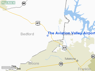
The Aviation Valley Airport |
Location & QuickFacts
| FAA Information Effective: | 2008-09-25 |
| Airport Identifier: | 6TN4 |
| Airport Status: | Operational |
| Longitude/Latitude: | 086-17-25.0000W/35-25-19.0000N
-86.290278/35.421944 (Estimated) |
| Elevation: | 890 ft / 271.27 m (Estimated) |
| Land: | 20 acres |
| From nearest city: | 5 nautical miles NW of Tullahoma, TN |
| Location: | Bedford County, TN |
| Magnetic Variation: | 01W (1990) |
Owner & Manager
| Ownership: | Privately owned |
| Owner: | Michael Loehle |
| Address: | 380 Shippmans Creek Road
Wartrace, TN 37183 |
| Phone number: | 931-857-3419 |
| Manager: | Michael Loehle
CONTACT: SANDY LOEHLE |
| Address: | 380 Shippmans Creek Road
Wartrace, TN 37183 |
| Phone number: | 931-857-3419 |
Airport Operations and Facilities
| Airport Use: | Private |
| Segmented Circle: | No |
| Control Tower: | No |
| Sectional chart: | Atlanta |
| Region: | ASO - Southern |
| Boundary ARTCC: | ZME - Memphis |
| Tie-in FSS: | BNA - Nashville |
| FSS on Airport: | No |
| FSS Toll Free: | 1-800-WX-BRIEF |
Runway Information
Runway 14/32
| Dimension: | 1800 x 100 ft / 548.6 x 30.5 m |
| Surface: | TURF, |
| |
Runway 14 |
Runway 32 |
| Traffic Pattern: | Left | Left |
|
Radio Navigation Aids
| ID |
Type |
Name |
Ch |
Freq |
Var |
Dist |
| SYI | FAN MARKER | Bomar | | | 01W | 9.3 nm |
| ULH | NDB | Burwi | | 332.00 | 03W | 3.4 nm |
| BGF | NDB | Boiling Fork | | 263.00 | 02W | 18.3 nm |
| TNY | NDB | Kelso | | 358.00 | 01W | 21.3 nm |
| UOS | NDB | Sewanee | | 275.00 | 02E | 23.4 nm |
| LUG | NDB | Verona | | 251.00 | 00W | 25.9 nm |
| RN | NDB | Warri | | 209.00 | 02W | 32.5 nm |
| FQW | NDB | Walter Hill | | 371.00 | 02W | 32.6 nm |
| SWZ | NDB | Sewart | | 391.00 | 02W | 33.2 nm |
| PBC | NDB | Maury County | | 365.00 | 01W | 40.8 nm |
| APT | NDB | Jasper | | 382.00 | 02W | 40.9 nm |
| GZS | NDB | Giles/dcmsnd | | 375.00 | 00E | 41.0 nm |
| SKN | NDB | Hurricane | | 256.00 | 02W | 41.2 nm |
| CWH | NDB | Capshaw | | 350.00 | 01W | 45.8 nm |
| JUE | NDB | Lebanon | | 414.00 | 02W | 46.3 nm |
| HUA | NDB | Redstone | | 287.00 | 00W | 47.7 nm |
| HEM | NDB | Huchn | | 233.00 | 02W | 48.4 nm |
| LRT | NDB | Lawrenceburg | | 269.00 | 00E | 48.9 nm |
| UXM | VOR | Tullahoma Regional | | 109.65 | 03W | 3.3 nm |
| SYI | VOR/DME | Shelbyville | 027X | 109.00 | 01W | 11.1 nm |
| RQZ | VORTAC | Rocket | 059X | 112.20 | 02E | 41.2 nm |
| BNA | VORTAC | Nashville | 088X | 114.10 | 02W | 47.1 nm |
| HSV | VOT | Huntsville | | 111.00 | | 35.5 nm |
| MQY | VOT | Smyrna | | 110.20 | | 36.7 nm |
| BNA | VOT | Nashville Metropoln | | 108.60 | | 46.5 nm |
Remarks
- RY 14/32 TREELINED.
- AIRSTRIP IS DOWN IN A NARROW VALLEY.
- VFR; PRIVATE USE ONLY.
Images and information placed above are from
http://www.airport-data.com/airport/6TN4/
We thank them for the data!
| General Info
|
| Country |
United States
|
| State |
TENNESSEE
|
| FAA ID |
6TN4
|
| Latitude |
35-25-19.000N
|
| Longitude |
086-17-25.000W
|
| Elevation |
890 feet
|
| Near City |
TULLAHOMA
|
We don't guarantee the information is fresh and accurate. The data may
be wrong or outdated.
For more up-to-date information please refer to other sources.
|
|


