 |
|
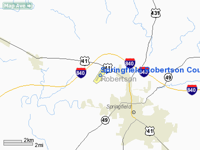
Springfield Robertson County Airport |
Location & QuickFacts
| FAA Information Effective: | 2008-09-25 |
| Airport Identifier: | M91 |
| Airport Status: | Operational |
| Longitude/Latitude: | 086-55-14.2400W/36-32-13.8600N
-86.920622/36.537183 (Estimated) |
| Elevation: | 707 ft / 215.49 m (Surveyed) |
| Land: | 148 acres |
| From nearest city: | 3 nautical miles NW of Springfield, TN |
| Location: | Robertson County, TN |
| Magnetic Variation: | 03W (2005) |
Owner & Manager
| Ownership: | Publicly owned |
| Owner: | Springfield-robertson Co
JOINT AIRPORT BOARD. |
| Address: | P.o.box 1125
Springfield, TN 37172-1125 |
| Phone number: | 615-384-4181 |
| Manager: | Walter T.mccauley |
| Address: | 4432 Airport Rd
Springfield, TN 37172 |
| Phone number: | 615-384-4181 |
Airport Operations and Facilities
| Airport Use: | Open to public |
| Wind indicator: | Yes |
| Segmented Circle: | Yes |
| Control Tower: | No |
| Lighting Schedule: | DUSK-DAWN
MIRL RY 04/22 PRESET ON LOW INTST; TO INCR INTST ACTVT - CTAF. |
| Beacon Color: | Clear-Green (lighted land airport) |
| Landing fee charge: | No |
| Sectional chart: | St Louis |
| Region: | ASO - Southern |
| Traffic Pattern Alt: | 1000 ft |
| Boundary ARTCC: | ZME - Memphis |
| Tie-in FSS: | BNA - Nashville |
| FSS on Airport: | No |
| FSS Toll Free: | 1-800-WX-BRIEF |
| NOTAMs Facility: | BNA (NOTAM-d service avaliable) |
| Federal Agreements: | NGY |
Airport Communications
| CTAF: | 123.000 |
| Unicom: | 123.000 |
Airport Services
| Fuel available: | 100LLA A1 |
| Airframe Repair: | MAJOR |
| Power Plant Repair: | MAJOR |
| Bottled Oxygen: | NONE |
| Bulk Oxygen: | NONE |
Runway Information
Runway 04/22
| Dimension: | 5006 x 100 ft / 1525.8 x 30.5 m |
| Surface: | ASPH, Good Condition |
| Weight Limit: | Single wheel: 38000 lbs.
Dual wheel: 52000 lbs. |
| Edge Lights: | Medium |
| |
Runway 04 |
Runway 22 |
| Longitude: | 086-55-30.9800W | 086-54-57.5000W |
| Latitude: | 36-31-53.1200N | 36-32-34.6000N |
| Elevation: | 700.00 ft | 707.00 ft |
| Alignment: | 33 | 127 |
| ILS Type: | LOCALIZER
| |
| Traffic Pattern: | Left | Left |
| Markings: | Non-precision instrument, Good Condition | Non-precision instrument, Good Condition |
| Crossing Height: | 0.00 ft | 26.00 ft |
| VASI: | 4-light PAPI on left side
RY 04 PAPI OTS INDEFLY. | 4-light PAPI on left side |
| Visual Glide Angle: | 0.00° | 4.00° |
| Runway End Identifier: | Yes | Yes |
| Obstruction: | 42 ft trees, 1419.0 ft from runway, 15 ft right of centerline, 29:1 slope to clear | 50 ft , 927.0 ft from runway, 276 ft left of centerline, 14:1 slope to clear |
|
Radio Navigation Aids
| ID |
Type |
Name |
Ch |
Freq |
Var |
Dist |
| PED | NDB | Needmore | | 221.00 | 01W | 0.2 nm |
| ON | NDB | Music | | 279.00 | 03W | 6.4 nm |
| VI | NDB | Opery | | 344.00 | 02W | 23.9 nm |
| FK | NDB | Airbe | | 273.00 | 01W | 26.6 nm |
| HIX | NDB | Honey Grove | | 356.00 | 01W | 28.8 nm |
| DMZ | NDB | Dickson | | 203.00 | 01W | 34.9 nm |
| JUE | NDB | Lebanon | | 414.00 | 02W | 36.0 nm |
| SWZ | NDB | Sewart | | 391.00 | 02W | 41.3 nm |
| LFB | NDB | Lafayette | | 245.00 | 02W | 41.5 nm |
| GMH | NDB | Muhlenberg | | 362.00 | 01E | 43.0 nm |
| FQW | NDB | Walter Hill | | 371.00 | 02W | 43.7 nm |
| AEY | NDB | Waverly | | 329.00 | 00E | 47.1 nm |
| HXW | TACAN | Screaming Eagle | 096X | | 01W | 28.9 nm |
| CKV | VOR/DME | Clarksville | 043X | 110.60 | 01W | 24.3 nm |
| BNA | VORTAC | Nashville | 088X | 114.10 | 02W | 26.6 nm |
| BWG | VORTAC | Bowling Green | 126X | 117.90 | 02E | 32.9 nm |
| GHM | VORTAC | Graham | 053X | 111.60 | 03E | 49.5 nm |
| BNA | VOT | Nashville Metropoln | | 108.60 | | 27.2 nm |
| MQY | VOT | Smyrna | | 110.20 | | 37.6 nm |
Remarks
- GCO AVBL ON FREQ 121.725 THRU BNA CLEARANCE DELIVERY.
- VFR ONLY.
Images and information placed above are from
http://www.airport-data.com/airport/M91/
We thank them for the data!
| General Info
|
| Country |
United States
|
| State |
TENNESSEE
|
| FAA ID |
M91
|
| Latitude |
36-32-13.860N
|
| Longitude |
086-55-14.240W
|
| Elevation |
707 feet
|
| Near City |
SPRINGFIELD
|
We don't guarantee the information is fresh and accurate. The data may
be wrong or outdated.
For more up-to-date information please refer to other sources.
|
|


