 |
|
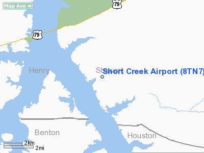
Location & QuickFacts
| FAA Information Effective: | 2008-09-25 |
| Airport Identifier: | 8TN7 |
| Airport Status: | Operational |
| Longitude/Latitude: | 087-59-30.0000W/36-24-03.0000N
-87.991667/36.400833 (Estimated) |
| Elevation: | 390 ft / 118.87 m (Estimated) |
| Land: | 15 acres |
| From nearest city: | 10 nautical miles SW of Dover, TN |
| Location: | Stewart County, TN |
| Magnetic Variation: | 01W (1995) |
Owner & Manager
| Ownership: | Privately owned |
| Owner: | William Holder |
| Address: | Po Box 53141
Knoxville, TN 37950 |
| Phone number: | 865-691-3165 |
| Address: |
|
Airport Operations and Facilities
| Airport Use: | Private |
| Wind indicator: | Yes |
| Segmented Circle: | No |
| Control Tower: | No |
| Sectional chart: | St Louis |
| Region: | ASO - Southern |
| Boundary ARTCC: | ZME - Memphis |
| Tie-in FSS: | MKL - Jackson |
| FSS on Airport: | No |
| FSS Toll Free: | 1-800-WX-BRIEF |
Runway Information
Runway 07/25
| Dimension: | 2560 x 30 ft / 780.3 x 9.1 m |
| Surface: | TURF, |
| |
Runway 07 |
Runway 25 |
| Traffic Pattern: | Left | Left |
|
Radio Navigation Aids
| ID |
Type |
Name |
Ch |
Freq |
Var |
Dist |
| AEY | NDB | Waverly | | 329.00 | 00E | 21.0 nm |
| TIQ | NDB | Trainer | | 410.00 | 00E | 22.4 nm |
| HZD | NDB | Huntingdon | | 217.00 | 00E | 29.7 nm |
| DMZ | NDB | Dickson | | 203.00 | 01W | 31.7 nm |
| GGK | NDB | Mayfield | | 401.00 | 00E | 33.8 nm |
| FK | NDB | Airbe | | 273.00 | 01W | 34.4 nm |
| HIX | NDB | Honey Grove | | 356.00 | 01W | 42.7 nm |
| ON | NDB | Music | | 279.00 | 03W | 48.4 nm |
| UC | NDB | Obion | | 212.00 | 00E | 49.0 nm |
| HXW | TACAN | Screaming Eagle | 096X | | 01W | 29.1 nm |
| CKV | VOR/DME | Clarksville | 043X | 110.60 | 01W | 31.0 nm |
| GHM | VORTAC | Graham | 053X | 111.60 | 03E | 43.0 nm |
Remarks
- 1100 FT MSL RADIO TWR 2 MI E OF ARPT.
- PRVDD VFR, PVT USE.
Images and information placed above are from
http://www.airport-data.com/airport/8TN7/
We thank them for the data!
| General Info
|
| Country |
United States
|
| State |
TENNESSEE
|
| FAA ID |
8TN7
|
| Latitude |
36-24-03.000N
|
| Longitude |
087-59-30.000W
|
| Elevation |
390 feet
|
| Near City |
DOVER
|
We don't guarantee the information is fresh and accurate. The data may
be wrong or outdated.
For more up-to-date information please refer to other sources.
|
|


