 |
|
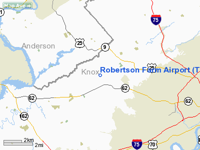
Location & QuickFacts
| FAA Information Effective: | 2008-09-25 |
| Airport Identifier: | TN94 |
| Airport Status: | Operational |
| Longitude/Latitude: | 084-04-28.0000W/36-00-04.0000N
-84.074444/36.001111 (Estimated) |
| Elevation: | 1020 ft / 310.90 m (Estimated) |
| Land: | 10 acres |
| From nearest city: | 8 nautical miles W of Knoxville, TN |
| Location: | Knox County, TN |
| Magnetic Variation: | 03W (1990) |
Owner & Manager
| Ownership: | Privately owned |
| Owner: | W. Barry Robertson, Jr. |
| Address: | 5321 W. Beaver Creek Dr.
Powell, TN 37849 |
| Phone number: | 865-947-0354 |
| Address: |
|
Airport Operations and Facilities
| Airport Use: | Private
PERSONAL USE. |
| Segmented Circle: | No |
| Control Tower: | No |
| Sectional chart: | Cincinnati |
| Region: | ASO - Southern |
| Boundary ARTCC: | ZTL - Atlanta |
| Tie-in FSS: | BNA - Nashville |
| FSS Toll Free: | 1-800-WX-BRIEF |
Runway Information
Runway 07/25
| Dimension: | 1700 x 100 ft / 518.2 x 30.5 m |
| Surface: | TURF, |
| |
Runway 07 |
Runway 25 |
| Traffic Pattern: | Left | Left |
| Obstruction: | 50 ft trees, 1000.0 ft from runway | 80 ft pline, 2200.0 ft from runway |
|
Radio Navigation Aids
| ID |
Type |
Name |
Ch |
Freq |
Var |
Dist |
| JAU | NDB | Jacksboro | | 204.00 | 03W | 20.7 nm |
| JXT | NDB | Jefferson | | 346.00 | 04W | 29.8 nm |
| MNV | NDB | Madisonville | | 361.00 | 04W | 31.3 nm |
| BPO | NDB | Piney Grove | | 403.00 | 05W | 37.8 nm |
| MMI | NDB | Mc Minn County | | 242.00 | 03W | 43.5 nm |
| VXV | VORTAC | Volunteer | 111X | 116.40 | 03W | 10.5 nm |
| HCH | VORTAC | Hinch Mountain | 123X | 117.60 | 02W | 46.0 nm |
| TYS | VOT | Knoxville | | 112.00 | | 12.0 nm |
Remarks
- RY 07/25 IS ONE WAY: LDG RY 07; TKOF RY 25
- PRVDD ALL OPNS ARE CONDUCTED IN VFR WX CONDS & LDG AREA IS LTD TO PERSONAL USE, THAT IS, BY OWNERS ONLY.
Images and information placed above are from
http://www.airport-data.com/airport/TN94/
We thank them for the data!
| General Info
|
| Country |
United States
|
| State |
TENNESSEE
|
| FAA ID |
TN94
|
| Latitude |
36-00-04.000N
|
| Longitude |
084-04-28.000W
|
| Elevation |
1020 feet
|
| Near City |
KNOXVILLE
|
We don't guarantee the information is fresh and accurate. The data may
be wrong or outdated.
For more up-to-date information please refer to other sources.
|
|


