 |
|
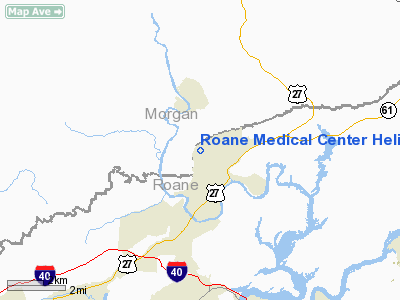
Roane Medical Center Heliport |
Location & QuickFacts
| FAA Information Effective: | 2008-09-25 |
| Airport Identifier: | TN19 |
| Airport Status: | Operational |
| Longitude/Latitude: | 084-33-02.7690W/35-57-46.2700N
-84.550769/35.962853 (Estimated) |
| Elevation: | 880 ft / 268.22 m (Estimated) |
| Land: | 0 acres |
| From nearest city: | 0 nautical miles N of Harriman, TN |
| Location: | Roane County, TN |
| Magnetic Variation: | 02W (1985) |
Owner & Manager
| Ownership: | Privately owned |
| Owner: | Roane Medical Center |
| Address: | 412 Devonia Street
Harriman, TN 37748 |
| Phone number: | 865-882-4346 |
| Manager: | J.m. Bullard |
| Address: | Roane Medical Center, 412 Devonia St
Harriman, TN 37748 |
| Phone number: | 865-882-4346 |
Airport Operations and Facilities
| Airport Use: | Private
MEDICAL USE. |
| Wind indicator: | Yes |
| Segmented Circle: | No |
| Control Tower: | No |
| Lighting Schedule: | PHONE REQ
FOR PERIMETER LIGHTS CALL 615-882-4312. |
| Sectional chart: | Memphis |
| Region: | ASO - Southern |
| Boundary ARTCC: | ZTL - Atlanta |
| Tie-in FSS: | BNA - Nashville |
| FSS Toll Free: | 1-800-WX-BRIEF |
Runway Information
Helipad H1
| Dimension: | 50 x 50 ft / 15.2 x 15.2 m |
| Surface: | CONC, |
| |
Runway H1 |
Runway |
| Traffic Pattern: | Left | Left |
|
Radio Navigation Aids
| ID |
Type |
Name |
Ch |
Freq |
Var |
Dist |
| MNV | NDB | Madisonville | | 361.00 | 04W | 26.4 nm |
| JAU | NDB | Jacksboro | | 204.00 | 03W | 29.4 nm |
| MMI | NDB | Mc Minn County | | 242.00 | 03W | 34.2 nm |
| DTE | NDB | Mark Anton | | 394.00 | 02W | 34.3 nm |
| BPO | NDB | Piney Grove | | 403.00 | 05W | 34.8 nm |
| HCH | VORTAC | Hinch Mountain | 123X | 117.60 | 02W | 23.5 nm |
| VXV | VORTAC | Volunteer | 111X | 116.40 | 03W | 32.1 nm |
| LVT | VORTAC | Livingston | 021X | 108.40 | 02W | 47.8 nm |
| TYS | VOT | Knoxville | | 112.00 | | 28.6 nm |
Remarks
- VFR, PRIVATE USE; APP COURSE SHOULD BE 80 DEGS OR 230 DEGS; DEP SHOULD BE 50 DEGS OR 260 DEGS; AREA IS MARKED; WIND INDICATOR IS MAINTAINED.
Images and information placed above are from
http://www.airport-data.com/airport/TN19/
We thank them for the data!
| General Info
|
| Country |
United States
|
| State |
TENNESSEE
|
| FAA ID |
TN19
|
| Latitude |
35-57-46.270N
|
| Longitude |
084-33-02.769W
|
| Elevation |
880 feet
|
| Near City |
HARRIMAN
|
We don't guarantee the information is fresh and accurate. The data may
be wrong or outdated.
For more up-to-date information please refer to other sources.
|
|


