 |
|
Location & QuickFacts
| FAA Information Effective: | 2008-09-25 |
| Airport Identifier: | TN61 |
| Airport Status: | Operational |
| Longitude/Latitude: | 089-52-06.3100W/35-12-06.3180N
-89.868419/35.201755 (Estimated) |
| Elevation: | 300 ft / 91.44 m (Estimated) |
| Land: | 0 acres |
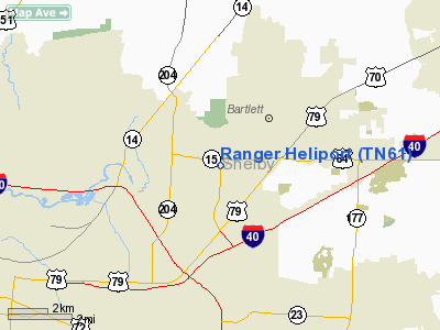
| From nearest city: | 3 nautical miles NE of Bartlett, TN |
| Location: | Shelby County, TN |
| Magnetic Variation: | 02E (1985) |
Owner & Manager
| Ownership: | Privately owned |
| Owner: | Ranger Tool Co |
| Address: | 5786 Ferguson
Bartlett, TN 38134 |
| Phone number: | 901-386-4514 |
| Manager: | Jerry W. Davis |
| Address: | 5786 Ferguson
Bartlett, TN 38134 |
| Phone number: | 901-386-4514 |
Airport Operations and Facilities
| Airport Use: | Private |
| Wind indicator: | No |
| Segmented Circle: | No |
| Control Tower: | No |
| Landing fee charge: | No |
| Sectional chart: | Memphis |
| Region: | ASO - Southern |
| Boundary ARTCC: | ZME - Memphis |
| Tie-in FSS: | MKL - Jackson |
| FSS on Airport: | No |
| FSS Toll Free: | 1-800-WX-BRIEF |
Airport Services
Runway Information
Helipad H1
| Dimension: | 603 x 452 ft / 183.8 x 137.8 m |
| Surface: | TURF, |
| |
Runway H1 |
Runway |
| Traffic Pattern: | Left | Left |
|
Radio Navigation Aids
| ID |
Type |
Name |
Ch |
Freq |
Var |
Dist |
| MIG | NDB | Millington | | 232.00 | 04E | 5.6 nm |
| SPQ | NDB | Spain | | 414.00 | 04E | 9.0 nm |
| ME | NDB | Elvis | | 287.00 | 01E | 13.1 nm |
| OLV | NDB | Olive Branch | | 275.00 | 01E | 13.9 nm |
| AWM | NDB | West Memphis | | 362.00 | 01E | 18.3 nm |
| FYE | NDB | Somerville | | 255.00 | 00E | 23.4 nm |
| COO | NDB | Covington | | 326.00 | 02E | 27.1 nm |
| BPW | NDB | Osceola | | 239.00 | 02E | 30.3 nm |
| BAV | NDB | Hardeman | | 404.00 | 01E | 40.6 nm |
| MXA | NDB | Manila | | 282.00 | 01E | 43.8 nm |
| IUI | NDB | Hicks | | 350.00 | 01E | 44.3 nm |
| FCY | NDB | Forrest City | | 332.00 | 01E | 47.2 nm |
| GOJ | VOR | Gosnell | | 111.80 | 01E | 45.2 nm |
| GQE | VOR/DME | Gilmore | 077X | 113.00 | 04E | 31.2 nm |
| MEM | VORTAC | Memphis | 122X | 117.50 | 01E | 12.6 nm |
| HLI | VORTAC | Holly Springs | 071X | 112.40 | 03E | 31.8 nm |
| MEM | VOT | Memphis Metropolitn | | 111.00 | | 10.6 nm |
Remarks
- E111 VFR WEATHER COND; PVT USE; COORD USE WITH MEMPHIS FSDO.
Images and information placed above are from
http://www.airport-data.com/airport/TN61/
We thank them for the data!
| General Info
|
| Country |
United States
|
| State |
TENNESSEE
|
| FAA ID |
TN61
|
| Latitude |
35-12-06.318N
|
| Longitude |
089-52-06.310W
|
| Elevation |
300 feet
|
| Near City |
BARTLETT
|
We don't guarantee the information is fresh and accurate. The data may
be wrong or outdated.
For more up-to-date information please refer to other sources.
|
|


