 |
|
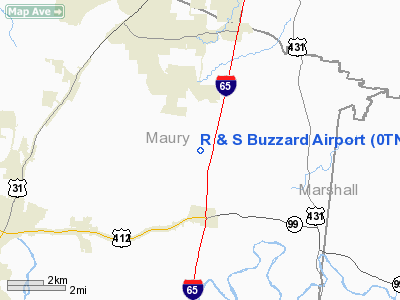
Location & QuickFacts
| FAA Information Effective: | 2008-09-25 |
| Airport Identifier: | 0TN0 |
| Airport Status: | Operational |
| Longitude/Latitude: | 086-53-48.0000W/35-40-36.0000N
-86.896667/35.676667 (Estimated) |
| Elevation: | 810 ft / 246.89 m (Estimated) |
| Land: | 3 acres |
| From nearest city: | 5 nautical miles S of Spring Hill, TN |
| Location: | Maury County, TN |
| Magnetic Variation: | 00W (1985) |
Owner & Manager
| Ownership: | Privately owned |
| Owner: | Marlin R. Bates |
| Address: | 2233 Bates Lane
Spring Hill, TN 37174 |
| Phone number: | 615-589-2000 |
| Manager: | Marlin R. Bates |
| Address: | 2233 Bates Lane
Spring Hill, TN 37174 |
| Phone number: | 615-381-6791 |
Airport Operations and Facilities
| Airport Use: | Private |
| Wind indicator: | Yes |
| Segmented Circle: | No |
| Control Tower: | No |
| Landing fee charge: | No |
| Sectional chart: | Atlanta |
| Region: | ASO - Southern |
| Boundary ARTCC: | ZME - Memphis |
| Tie-in FSS: | MKL - Jackson |
| FSS on Airport: | No |
| FSS Toll Free: | 1-800-WX-BRIEF |
Runway Information
Runway 17/35
| Dimension: | 1750 x 100 ft / 533.4 x 30.5 m |
| Surface: | TURF, |
| |
Runway 17 |
Runway 35 |
| Traffic Pattern: | Left | Left |
| Obstruction: | | 4 ft fence, 10.0 ft from runway |
|
Radio Navigation Aids
| ID |
Type |
Name |
Ch |
Freq |
Var |
Dist |
| SYI | FAN MARKER | Bomar | | | 01W | 24.1 nm |
| PBC | NDB | Maury County | | 365.00 | 01W | 10.4 nm |
| LUG | NDB | Verona | | 251.00 | 00W | 11.4 nm |
| SWZ | NDB | Sewart | | 391.00 | 02W | 27.0 nm |
| FQW | NDB | Walter Hill | | 371.00 | 02W | 30.8 nm |
| LRT | NDB | Lawrenceburg | | 269.00 | 00E | 31.9 nm |
| GZS | NDB | Giles/dcmsnd | | 375.00 | 00E | 32.5 nm |
| VI | NDB | Opery | | 344.00 | 02W | 33.8 nm |
| ULH | NDB | Burwi | | 332.00 | 03W | 34.5 nm |
| TNY | NDB | Kelso | | 358.00 | 01W | 37.0 nm |
| DMZ | NDB | Dickson | | 203.00 | 01W | 37.6 nm |
| JHG | NDB | Hohenwald | | 257.00 | 01W | 38.1 nm |
| JUE | NDB | Lebanon | | 414.00 | 02W | 42.0 nm |
| ON | NDB | Music | | 279.00 | 03W | 46.7 nm |
| AEY | NDB | Waverly | | 329.00 | 00E | 48.9 nm |
| UXM | VOR | Tullahoma Regional | | 109.65 | 03W | 36.5 nm |
| SYI | VOR/DME | Shelbyville | 027X | 109.00 | 01W | 23.4 nm |
| GHM | VORTAC | Graham | 053X | 111.60 | 03E | 28.7 nm |
| BNA | VORTAC | Nashville | 088X | 114.10 | 02W | 29.5 nm |
| MQY | VOT | Smyrna | | 110.20 | | 27.4 nm |
| BNA | VOT | Nashville Metropoln | | 108.60 | | 29.0 nm |
| HSV | VOT | Huntsville | | 111.00 | | 42.2 nm |
Remarks
Images and information placed above are from
http://www.airport-data.com/airport/0TN0/
We thank them for the data!
|
|


