 |
|
Clarksville-Montgomery County Regional Airport
John F. Outlaw Field |
 |
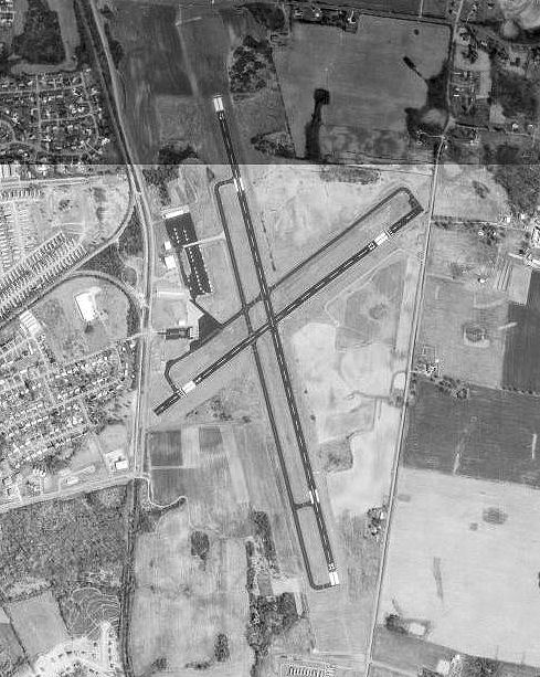 |
| USGS aerial image, 27 March 1992 |
| IATA: CKV – ICAO: KCKV – FAA LID: CKV |
| Summary |
| Airport type |
Public |
| Owner |
City of Clarksville & Montgomery County |
| Serves |
Clarksville, Tennessee |
| Elevation AMSL |
550 ft / 168 m |
| Coordinates |
36°37′19″N 087°24′54″W / 36.62194°N 87.415°W / 36.62194; -87.415 |
| Website |
ClarksvilleAirport.com |
| Runways |
| Direction |
Length |
Surface |
| ft |
m |
| 17/35 |
6,000 |
1,829 |
Asphalt |
| 5/23 |
4,004 |
1,220 |
Asphalt |
| Statistics (2009) |
| Aircraft operations |
20,600 |
| Based aircraft |
40 |
| Sources: airport web site and FAA |
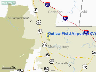
Clarksville-Montgomery County Regional Airport (IATA: CKV, ICAO: KCKV, FAA LID: CKV), also known as John F. Outlaw Field or simply Outlaw Field, is a public use airport located six nautical miles (11 km) northwest of the central business district of Clarksville, a city in Montgomery County, Tennessee, United States. It is owned by the city of Clarksville and Montgomery County. The airport is located near Fort Campbell. History
Opened in 1937 as a private airport. Taken over during World War II by the United States Army Air Corps and known as Clarksville Army Airfield. Established as a sub-base for the larger Campbell Army Airfield at Fort Campbell, Kentucky. Activated on 1 June 1942 as a primary basic flying training (level 1) airfield. Conducted flying training until inactivated on 31 October 1945. Remained inactive until transferred to USAF Tactical Air Command on 31 March 1946. Remained under USAF control until 1959 when the Air Force turned over all airport facilities to the United States Army. Returned to public airport status, 1960.
Facilities and aircraft
Outlaw Field covers an area of 452 acres (183 ha) at an elevation of 550 feet (168 m) above mean sea level. It has two asphalt paved runways: 17/35 is 6,000 by 100 feet (1,829 x 30 m) and 5/23 is 4,004 by 100 feet.
For the 12-month period ending December 15, 2009, the airport had 20,600 aircraft operations, an average of 56 per day: 89% general aviation, 10% military, and 1% air taxi. At that time there were 40 aircraft based at this airport: 75% single-engine, 20% multi-engine, 2.5% jet and 2.5% helicopter.
Outlaw Field has several FBOs and flight training facilities. Volunteer Aviation (www.volunteeraviation.com) is a full service flight school located at the airport.
The above content comes from Wikipedia and is published under free licenses – click here to read more.
Location & QuickFacts
| FAA Information Effective: | 2008-09-25 |
| Airport Identifier: | CKV |
| Airport Status: | Operational |
| Longitude/Latitude: | 087-24-53.8330W/36-37-18.7710N
-87.414954/36.621881 (Estimated) |
| Elevation: | 550 ft / 167.64 m (Surveyed) |
| Land: | 452 acres |
| From nearest city: | 6 nautical miles NW of Clarksville, TN |
| Location: | Montgomery County, TN |
| Magnetic Variation: | 01W (1990) |
Owner & Manager
| Ownership: | Publicly owned |
| Owner: | Clarksville Montgomery County
AIRPORT AUTHORITY. |
| Address: | 200 Airport Rd
Clarksville, TN 37042 |
| Phone number: | 931-431-2080 |
| Manager: | Mr. Pat Ryan |
| Address: | 200 Airport Road - Bldg 1
Clarksville, TN 37042 |
| Phone number: | 931-431-2080 |
Airport Operations and Facilities
| Airport Use: | Open to public |
| Wind indicator: | Yes |
| Segmented Circle: | Yes |
| Control Tower: | No |
| Lighting Schedule: | DUSK-DAWN
ACTVT REIL RY 17 & MALS RY 35 - CTAF. |
| Beacon Color: | Clear-Green (lighted land airport) |
| Landing fee charge: | No |
| Sectional chart: | St Louis |
| Region: | ASO - Southern |
| Traffic Pattern Alt: | 950 ft |
| Boundary ARTCC: | ZME - Memphis |
| Tie-in FSS: | MKL - Jackson |
| FSS on Airport: | No |
| FSS Toll Free: | 1-800-WX-BRIEF |
| NOTAMs Facility: | CKV (NOTAM-d service avaliable) |
| Federal Agreements: | NGY |
Airport Communications
| CTAF: | 122.800 |
| Unicom: | 122.800 |
Airport Services
| Fuel available: | 100LLA+
FOR SVC AFT HRS CALL 931-320-7753. |
| Airframe Repair: | MAJOR |
| Power Plant Repair: | MAJOR |
Runway Information
Runway 05/23
| Dimension: | 4004 x 100 ft / 1220.4 x 30.5 m |
| Surface: | ASPH, Good Condition |
| Weight Limit: | Single wheel: 40000 lbs.
Dual wheel: 60000 lbs. |
| |
Runway 05 |
Runway 23 |
| Longitude: | 087-25-12.1750W | 087-24-33.4400W |
| Latitude: | 36-37-08.6990N | 36-37-33.0440N |
| Elevation: | 540.00 ft | 533.00 ft |
| Alignment: | 52 | 127 |
| Traffic Pattern: | Right | Left |
| Markings: | Non-precision instrument, Good Condition | Non-precision instrument, Good Condition |
| Displaced threshold: | 402.00 ft | 503.00 ft |
| Obstruction: | 44 ft tree, 366.0 ft from runway, 54 ft right of centerline, 4:1 slope to clear
APCH RATIO 17:1 TO DSPLCD THLD.
FENCE 100 FT FM END OF RY. | 69 ft tree, 1140.0 ft from runway, 15 ft right of centerline, 13:1 slope to clear
APCH RATIO 23:1 TO DSPLCD THLD.
FENCE 110 FT FM END OF RY. |
|
Runway 17/35
| Dimension: | 6000 x 100 ft / 1828.8 x 30.5 m |
| Surface: | ASPH, Good Condition |
| Weight Limit: | Single wheel: 60000 lbs.
Dual wheel: 90000 lbs. |
| Edge Lights: | Medium |
| |
Runway 17 |
Runway 35 |
| Longitude: | 087-25-03.3120W | 087-24-45.6920W |
| Latitude: | 36-37-46.0890N | 36-36-48.4880N |
| Elevation: | 538.00 ft | 549.00 ft |
| Alignment: | 127 | 127 |
| ILS Type: | | LOCALIZER
|
| Traffic Pattern: | Left | Right |
| Markings: | Non-precision instrument, Good Condition | Non-precision instrument, Good Condition |
| Crossing Height: | 50.00 ft | 50.00 ft |
| VASI: | 2-light PAPI on left side | 2-light PAPI on left side |
| Visual Glide Angle: | 3.00° | 0.00° |
| Approach lights: | | MALS |
| Runway End Identifier: | Yes | |
| Obstruction: | 82 ft tree, 2184.0 ft from runway, 629 ft right of centerline, 24:1 slope to clear | 46 ft trees, 1581.0 ft from runway, 264 ft left of centerline, 30:1 slope to clear |
|
Radio Navigation Aids
| ID |
Type |
Name |
Ch |
Freq |
Var |
Dist |
| FK | NDB | Airbe | | 273.00 | 01W | 6.9 nm |
| HIX | NDB | Honey Grove | | 356.00 | 01W | 16.0 nm |
| ON | NDB | Music | | 279.00 | 03W | 22.8 nm |
| PED | NDB | Needmore | | 221.00 | 01W | 24.6 nm |
| DMZ | NDB | Dickson | | 203.00 | 01W | 29.7 nm |
| AEY | NDB | Waverly | | 329.00 | 00E | 34.3 nm |
| GMH | NDB | Muhlenberg | | 362.00 | 01E | 38.4 nm |
| VI | NDB | Opery | | 344.00 | 02W | 44.6 nm |
| HXW | TACAN | Screaming Eagle | 096X | | 01W | 5.0 nm |
| CKV | VOR/DME | Clarksville | 043X | 110.60 | 01W | 0.1 nm |
| BNA | VORTAC | Nashville | 088X | 114.10 | 02W | 45.8 nm |
| CCT | VORTAC | Central City | 035X | 109.80 | 01W | 46.3 nm |
| GHM | VORTAC | Graham | 053X | 111.60 | 03E | 47.4 nm |
| BNA | VOT | Nashville Metropoln | | 108.60 | | 46.3 nm |
Remarks
- EXTSV MIL & CIVIL FLIGHT TRNG WITHIN ARPT AREA.
- DEER ON & INVOF ARPT.
Images and information placed above are from
http://www.airport-data.com/airport/CKV/
We thank them for the data!
| General Info
|
| Country |
United States
|
| State |
TENNESSEE
|
| FAA ID |
CKV
|
| Latitude |
36-37-18.771N
|
| Longitude |
087-24-53.833W
|
| Elevation |
550 feet
|
| Near City |
CLARKSVILLE
|
We don't guarantee the information is fresh and accurate. The data may
be wrong or outdated.
For more up-to-date information please refer to other sources.
|
|


