 |
|
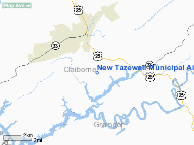
New Tazewell Muni Airport |
Location & QuickFacts
| FAA Information Effective: | 2008-09-25 |
| Airport Identifier: | 3A2 |
| Airport Status: | Operational |
| Longitude/Latitude: | 083-33-19.6620W/36-24-36.3030N
-83.555462/36.410084 (Estimated) |
| Elevation: | 1179 ft / 359.36 m (Estimated) |
| Land: | 125 acres |
| From nearest city: | 3 nautical miles SE of Tazewell, TN |
| Location: | Claiborne County, TN |
| Magnetic Variation: | 03W (1985) |
Owner & Manager
| Ownership: | Publicly owned |
| Owner: | City Of New Tazewell |
| Address: | Po Box 609
New Tazewell, TN 37825 |
| Phone number: | 423-626-5242 |
| Manager: | David Teague |
| Address: | 390 Airport Lane
Tazewell, TN 37879 |
| Phone number: | 423-626-2508 |
Airport Operations and Facilities
| Airport Use: | Open to public |
| Wind indicator: | Yes |
| Segmented Circle: | Yes |
| Control Tower: | No |
| Lighting Schedule: | DUSK-DAWN
ACTVT PAPI RYS 07 & 25 - CTAF. |
| Beacon Color: | Clear-Green (lighted land airport) |
| Landing fee charge: | No |
| Sectional chart: | Cincinnati |
| Region: | ASO - Southern |
| Boundary ARTCC: | ZTL - Atlanta |
| Tie-in FSS: | BNA - Nashville |
| FSS on Airport: | No |
| FSS Toll Free: | 1-800-WX-BRIEF |
| NOTAMs Facility: | BNA (NOTAM-d service avaliable) |
| Federal Agreements: | NY1 |
Airport Communications
Airport Services
| Fuel available: | 100LL |
| Airframe Repair: | MAJOR |
| Power Plant Repair: | MAJOR |
| Bottled Oxygen: | NONE |
| Bulk Oxygen: | NONE |
Runway Information
Runway 07/25
| Dimension: | 3000 x 75 ft / 914.4 x 22.9 m |
| Surface: | ASPH, Good Condition |
| Weight Limit: | Single wheel: 16000 lbs.
Dual wheel: 24000 lbs. |
| Edge Lights: | Medium |
| |
Runway 07 |
Runway 25 |
| Traffic Pattern: | Left | Left |
| Markings: | Basic, Fair Condition | Basic, Fair Condition |
| VASI: | 2-light PAPI on left side | 2-light PAPI on left side |
| Runway End Identifier: | Yes | Yes |
| Touchdown Lights: | No | No |
| Obstruction: | 40 ft trees, 1400.0 ft from runway, 99 ft right of centerline, 30:1 slope to clear | 70 ft trees, 2400.0 ft from runway, 533 ft right of centerline, 31:1 slope to clear
HIGH TERRAIN APRXLY 2 MILES FM RY END. |
|
Radio Navigation Aids
| ID |
Type |
Name |
Ch |
Freq |
Var |
Dist |
| JXT | NDB | Jefferson | | 346.00 | 04W | 18.4 nm |
| LQV | NDB | Long Hollow | | 252.00 | 03W | 29.3 nm |
| JAU | NDB | Jacksboro | | 204.00 | 03W | 29.6 nm |
| RVN | NDB | Rogersville | | 329.00 | 04W | 32.6 nm |
| DYQ | NDB | Dulaney | | 263.00 | 04W | 36.2 nm |
| BPO | NDB | Piney Grove | | 403.00 | 05W | 45.2 nm |
| VXV | VORTAC | Volunteer | 111X | 116.40 | 03W | 34.5 nm |
| SOT | VORTAC | Snowbird | 025X | 108.80 | 04W | 44.6 nm |
| LOZ | VORTAC | London | 108X | 116.10 | 03W | 46.0 nm |
| TYS | VOT | Knoxville | | 112.00 | | 41.7 nm |
Remarks
Images and information placed above are from
http://www.airport-data.com/airport/3A2/
We thank them for the data!
| General Info
|
| Country |
United States
|
| State |
TENNESSEE
|
| FAA ID |
3A2
|
| Latitude |
36-24-36.303N
|
| Longitude |
083-33-19.662W
|
| Elevation |
1179 feet
|
| Near City |
TAZEWELL
|
We don't guarantee the information is fresh and accurate. The data may
be wrong or outdated.
For more up-to-date information please refer to other sources.
|
|


