 |
|
Murfreesboro Muni Airport |
| Murfreesboro Municipal Airport |
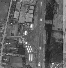 |
| USGS image of Murfreesboro Municipal |
| IATA: none – ICAO: KMBT – FAA LID: MBT |
| Summary |
| Airport type |
Public |
| Owner/Operator |
City of Murfreesboro |
| Location |
Murfreesboro, TN |
| Elevation AMSL |
614 ft / 187 m |
| Coordinates |
35°52.65′N 86°22.65′W / 35.8775°N 86.3775°W / 35.8775; -86.3775Coordinates: 35°52.65′N 86°22.65′W / 35.8775°N 86.3775°W / 35.8775; -86.3775 |
| Website |
MurfreesboroTN.gov |
| Runways |
| Direction |
Length |
Surface |
| ft |
m |
| 18/36 |
3898 |
1188 |
Asphalt |
| FAA |
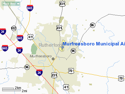
Murfreesboro Municipal Airport (ICAO: KMBT, FAA LID: MBT) is about 2 nm north of the central business district of Murfreesboro, Tennessee, United States. It is also the home of the Middle Tennessee State University Aerospace aircraft and simulators. MTSU has 1- Boeing 727, 1- Diamond DA-20s, 17- Diamond DA-40s with the Garmin 1000 avionics suite, 2- Diamond DA-40s without the Garmin 1000 avionics suite, 3- Piper PA-28R Arrows, 2- Piper PA-44 Seminole, 3- Cessna 152s, 1- Piper Super Cub, 1- de Havilland Canada DHC-2 Beaver, 1-Beechcraft King Air 200, 1- Cessna T-41 and 1- Cessna 172RG.
The airport has one runway (18-36), 3,898 ft long (1,188 m) by 100 ft wide (30 m).
The Murfreesboro Municipal Airport is one of the only General Aviation Airports in the State of Tennessee that does not receive tax payer money. The money used to maintain the airport is entirely generated by leases and fuel sales.
In 2007 the airport won the Tennessee Airport of the Year award.
The above content comes from Wikipedia and is published under free licenses – click here to read more.
Location & QuickFacts
| FAA Information Effective: | 2008-09-25 |
| Airport Identifier: | MBT |
| Airport Status: | Operational |
| Longitude/Latitude: | 086-22-39.0000W/35-52-39.0000N
-86.377500/35.877500 (Estimated) |
| Elevation: | 615 ft / 187.45 m (Surveyed) |
| Land: | 225 acres |
| From nearest city: | 2 nautical miles N of Murfreesboro, TN |
| Location: | Rutherford County, TN |
| Magnetic Variation: | 02W (2000) |
Owner & Manager
| Ownership: | Publicly owned |
| Owner: | City Of Murfreesboro |
| Address: | City Hall, 111 W Vine St.
Murfreesboro, TN 37130 |
| Phone number: | 615-893-5210 |
| Manager: | Chad Gehrke |
| Address: | 1930 Memorial Blvd.
Murfreesboro, TN 37129 |
| Phone number: | 615-848-3254 |
Airport Operations and Facilities
| Airport Use: | Open to public |
| Wind indicator: | Yes |
| Segmented Circle: | Yes |
| Control Tower: | No |
| Lighting Schedule: | DUSK-DAWN |
| Beacon Color: | Clear-Green (lighted land airport) |
| Landing fee charge: | No |
| Sectional chart: | Atlanta |
| Region: | ASO - Southern |
| Boundary ARTCC: | ZME - Memphis |
| Tie-in FSS: | BNA - Nashville |
| FSS on Airport: | No |
| FSS Toll Free: | 1-800-WX-BRIEF |
| NOTAMs Facility: | BNA (NOTAM-d service avaliable) |
| Federal Agreements: | NGY |
Airport Communications
| CTAF: | 122.700 |
| Unicom: | 122.700 |
Airport Services
| Fuel available: | 100 A |
| Airframe Repair: | MAJOR |
| Power Plant Repair: | MAJOR |
| Bottled Oxygen: | LOW |
| Bulk Oxygen: | LOW |
Runway Information
Runway 18/36
| Dimension: | 3898 x 100 ft / 1188.1 x 30.5 m |
| Surface: | ASPH, Fair Condition |
| Weight Limit: | Single wheel: 30000 lbs. |
| Edge Lights: | Medium |
| |
Runway 18 |
Runway 36 |
| Longitude: | 086-22-38.1000W | 086-22-40.1300W |
| Latitude: | 35-52-58.2000N | 35-52-19.6900N |
| Elevation: | 600.00 ft | 615.00 ft |
| Alignment: | 127 | 2 |
| Traffic Pattern: | Left | Left |
| Markings: | Non-precision instrument, Good Condition | Non-precision instrument, Good Condition |
| Crossing Height: | 21.00 ft | 24.00 ft |
| VASI: | 2-box SAVASI on left side | 2-box SAVASI on right side |
| Visual Glide Angle: | 3.00° | 3.50° |
| Runway End Identifier: | Yes
& 36 REIL OTS INDEFLY. | Yes |
| Obstruction: | 62 ft tree, 2313.0 ft from runway, 106 ft left of centerline, 34:1 slope to clear | 72 ft trees, 1533.0 ft from runway, 98 ft right of centerline, 18:1 slope to clear |
|
Radio Navigation Aids
| ID |
Type |
Name |
Ch |
Freq |
Var |
Dist |
| SYI | FAN MARKER | Bomar | | | 01W | 24.0 nm |
| FQW | NDB | Walter Hill | | 371.00 | 02W | 5.0 nm |
| SWZ | NDB | Sewart | | 391.00 | 02W | 6.4 nm |
| JUE | NDB | Lebanon | | 414.00 | 02W | 19.2 nm |
| VI | NDB | Opery | | 344.00 | 02W | 23.7 nm |
| ULH | NDB | Burwi | | 332.00 | 03W | 25.9 nm |
| SKN | NDB | Hurricane | | 256.00 | 02W | 28.4 nm |
| RN | NDB | Warri | | 209.00 | 02W | 30.8 nm |
| LUG | NDB | Verona | | 251.00 | 00W | 31.0 nm |
| PBC | NDB | Maury County | | 365.00 | 01W | 38.4 nm |
| HEM | NDB | Huchn | | 233.00 | 02W | 39.1 nm |
| LFB | NDB | Lafayette | | 245.00 | 02W | 41.3 nm |
| BGF | NDB | Boiling Fork | | 263.00 | 02W | 44.7 nm |
| TNY | NDB | Kelso | | 358.00 | 01W | 45.4 nm |
| ON | NDB | Music | | 279.00 | 03W | 45.5 nm |
| UOS | NDB | Sewanee | | 275.00 | 02E | 46.8 nm |
| PED | NDB | Needmore | | 221.00 | 01W | 47.5 nm |
| UXM | VOR | Tullahoma Regional | | 109.65 | 03W | 30.6 nm |
| SYI | VOR/DME | Shelbyville | 027X | 109.00 | 01W | 19.2 nm |
| BNA | VORTAC | Nashville | 088X | 114.10 | 02W | 21.6 nm |
| MQY | VOT | Smyrna | | 110.20 | | 10.0 nm |
| BNA | VOT | Nashville Metropoln | | 108.60 | | 21.1 nm |
Remarks
- EXTENSIVE STUDENT FLIGHT TRNG 0800-1700. STANDARD TFC PATTERN REQUIRED OF ALL ACFT.
- GCO AVBL ON FREQ 135.075 THRU BNA CLEARANCE DELIVERY.
- RY 36 DESIGNATED CALM WIND RY.
Images and information placed above are from
http://www.airport-data.com/airport/MBT/
We thank them for the data!
| General Info
|
| Country |
United States
|
| State |
TENNESSEE
|
| FAA ID |
MBT
|
| Latitude |
35-52-38.944N
|
| Longitude |
086-22-39.116W
|
| Elevation |
615 feet
|
| Near City |
MURFREESBORO
|
We don't guarantee the information is fresh and accurate. The data may
be wrong or outdated.
For more up-to-date information please refer to other sources.
|
|


