 |
|
Millington Rgnl Jetport Airport |
| Millington Regional Jetport |
 |
| IATA: NQA – ICAO: KNQA |
| Summary |
| Airport type |
Public |
| Operator |
Millington Airport Authority |
| Location |
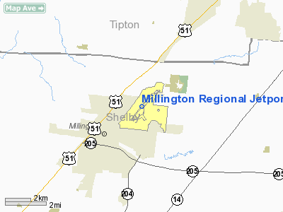
Millington, Tennessee |
| Elevation AMSL |
320 ft / 97.5 m |
| Coordinates |
35°21′24″N 89°52′13″W / 35.35667°N 89.87028°W / 35.35667; -89.87028Coordinates: 35°21′24″N 89°52′13″W / 35.35667°N 89.87028°W / 35.35667; -89.87028 |
| Runways |
| Direction |
Length |
Surface |
| ft |
m |
| 4/22 |
8,000 |
2,438 |
Asphalt/Concrete |
Millington Regional Jetport (IATA: NQA, ICAO: KNQA), formerly known as Millington Municipal Airport, is a public airport in the city of Millington, in Shelby County, Tennessee, USA. The airport is located 16 miles (26 km) north of Memphis. It was formerly known as Naval Air Station Memphis and it still provides support to military aircraft visiting the adjacent Naval Support Activity Mid-South. Facilities
Millington Regional Jetport covers 400 acres (162 ha) and has one runway:
- Runway 4/22: 8,000 x 200 ft. (2,438 x 61 m), Surface: Asphalt/Concrete
General
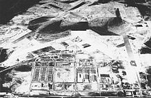 | |
Aerial view of NAS Memphis in the mid-1940s. |
Originally constructed in 1942 as Naval Air Station Memphis, the airfield provided pilot training during World War II. During the postwar period of the mid-1940s through the mid-1990s, NAS Memphis hosted numerous locally-based Naval Air Reserve and Marine Air Reserve flying squadrons, as well as a major naval air technical training center (NATTC Millington) that provided the bulk of enlisted aviation speciality training for the United States Navy and Marine Corps. The original NAS Memphis comprised over 3,800 acres.
The 1993 Base Realignment and Closure (BRAC) Commission report resulted in significant changes to the base's mission and its redesignation in 1995 as Naval Support Activity Memphis. The airfield and flight line proper was turned over to the city of Millington, which is now the Millington Regional Jetport.
In 1998, the name of the remaining naval base (i.e., non-airfield) was changed to the Naval Support Activity Mid-South to better reflect its current mission and the Navy's approach to regionalization. Naval Support Activity Mid-South is one of the largest single employers in the state of Tennessee, with approximately 6000 military, civilian and contractor employees on 1,950 acres. The naval base hosts many tenant organizations, notably the Commander, Navy Personnel Command (NAVPERSCOM) and the Bureau of Naval Personnel (BUPERS).
On December 9, 2008, a Mitsubishi MU-2 crash-landed on runway 4 while passing through the area. The pilot announced that he may have not been able to reach the airport and have to land on U.S. Highway 51. The pilot was taken to a local hospital in stable condition, and the FAA and NTSB are currently investigating the incident.
The above content comes from Wikipedia and is published under free licenses – click here to read more.
Location & QuickFacts
| FAA Information Effective: | 2008-09-25 |
| Airport Identifier: | NQA |
| Airport Status: | Operational |
| Longitude/Latitude: | 089-52-13.0000W/35-21-24.0000N
-89.870278/35.356667 (Estimated) |
| Elevation: | 320 ft / 97.54 m (Estimated) |
| Land: | 400 acres |
| From nearest city: | 1 nautical miles NE of Millington, TN |
| Location: | Shelby County, TN |
| Magnetic Variation: | 00E (2000) |
Owner & Manager
| Ownership: | Publicly owned |
| Owner: | Millington Arpt Auth |
| Address: | 8182 Hornet Avenue
Millington, TN 38053 |
| Phone number: | 901-872-7495 |
| Manager: | Tracy L. Williams |
| Address: | 8182 Hornet Avenue
Millington, TN 38053 |
| Phone number: | 901-873-5792
ARPT DIRECTOR CELL 901-826-1356, FAX 901-873-5795. |
Airport Operations and Facilities
| Airport Use: | Open to public |
| Wind indicator: | Yes |
| Segmented Circle: | Yes |
| Control Tower: | Yes |
| Lighting Schedule: | DUSK-DAWN
HIRL RY 04/22 AND MALSR RY 22 PRESET LOW INTST; TO INCR INTST & ACTVT REIL RYS 04 & 22 AND MALSR RY 22 - CTAF. |
| Beacon Color: | Clear-Green (lighted land airport) |
| Sectional chart: | Memphis |
| Region: | ASO - Southern |
| Boundary ARTCC: | ZME - Memphis |
| Tie-in FSS: | MKL - Jackson |
| FSS on Airport: | No |
| FSS Toll Free: | 1-800-WX-BRIEF |
| NOTAMs Facility: | NQA (NOTAM-d service avaliable) |
| Certification type/date: | I A U 12/1995
ARPT CLSD TO ACR OPNS WITH MORE THAN 30 PSGR SEATS EXCEPT 24 HR PPR; CALL 901-872-8700. INDEX D AVBL WITH PRIOR NOTICE |
| Federal Agreements: | N |
Airport Communications
| CTAF: | 120.250 |
| Unicom: | 122.950 |
Airport Services
| Fuel available: | 100LLA+
JASU AVBL. |
| Airframe Repair: | MAJOR |
| Power Plant Repair: | MAJOR |
| Bottled Oxygen: | LOW |
| Bulk Oxygen: | NONE |
Runway Information
Runway 04/22
| Dimension: | 8000 x 200 ft / 2438.4 x 61.0 m |
| Surface: | ASPH-CONC, Good Condition |
| Surface Treatment: | Saw-cut or plastic Grooved
FIRST 1000 FT BOTH ENDS & 3000 FT OF NE PORTION NOT GROOVED. |
| Weight Limit: | Single wheel: 150000 lbs.
Dual wheel: 170000 lbs.
Dual tandem wheel: 309000 lbs. |
| Edge Lights: | High |
| |
Runway 04 |
Runway 22 |
| Longitude: | 089-52-43.8600W | 089-51-43.2200W |
| Latitude: | 35-20-53.1200N | 35-21-54.7000N |
| Elevation: | 276.00 ft | 320.00 ft |
| Alignment: | 39 | 127 |
| ILS Type: | | ILS/DME
|
| Traffic Pattern: | Left | Right |
| Markings: | Precision instrument, Good Condition | Precision instrument, Good Condition |
| Crossing Height: | 73.00 ft | 73.00 ft |
| VASI: | 4-light PAPI on left side | 4-light PAPI on left side |
| Visual Glide Angle: | 3.00° | 3.00° |
| Approach lights: | | MALSR |
| Runway End Identifier: | Yes | Yes
RY 22 REIL OTS INDEFLY. |
|
Radio Navigation Aids
| ID |
Type |
Name |
Ch |
Freq |
Var |
Dist |
| MIG | NDB | Millington | | 232.00 | 04E | 5.6 nm |
| SPQ | NDB | Spain | | 414.00 | 04E | 12.9 nm |
| COO | NDB | Covington | | 326.00 | 02E | 19.7 nm |
| ME | NDB | Elvis | | 287.00 | 01E | 20.3 nm |
| BPW | NDB | Osceola | | 239.00 | 02E | 21.4 nm |
| AWM | NDB | West Memphis | | 362.00 | 01E | 22.1 nm |
| OLV | NDB | Olive Branch | | 275.00 | 01E | 23.0 nm |
| FYE | NDB | Somerville | | 255.00 | 00E | 25.1 nm |
| IUI | NDB | Hicks | | 350.00 | 01E | 35.0 nm |
| MXA | NDB | Manila | | 282.00 | 01E | 35.1 nm |
| BAV | NDB | Hardeman | | 404.00 | 01E | 41.5 nm |
| DNT | NDB | Nally Dunston | | 343.00 | 01W | 44.6 nm |
| GOJ | VOR | Gosnell | | 111.80 | 01E | 35.9 nm |
| GQE | VOR/DME | Gilmore | 077X | 113.00 | 04E | 29.8 nm |
| JBR | VOR/DME | Jonesboro | 023X | 108.60 | 02E | 46.9 nm |
| MKL | VOR/DME | Mc Kellar | 057X | 112.00 | 02E | 49.3 nm |
| MEM | VORTAC | Memphis | 122X | 117.50 | 01E | 21.3 nm |
| HLI | VORTAC | Holly Springs | 071X | 112.40 | 03E | 39.8 nm |
| DYR | VORTAC | Dyersburg | 115X | 116.80 | 03E | 48.1 nm |
| MEM | VOT | Memphis Metropolitn | | 111.00 | | 19.2 nm |
Remarks
- CAT C AFLD.
- TWY 'B' CLSD TO AIR CARRIER OPNS.
Images and information placed above are from
http://www.airport-data.com/airport/NQA/
We thank them for the data!
| General Info
|
| Country |
United States
|
| State |
TENNESSEE
|
| FAA ID |
NQA
|
| Latitude |
35-21-24.000N
|
| Longitude |
089-52-13.000W
|
| Elevation |
320 feet
|
| Near City |
MILLINGTON
|
We don't guarantee the information is fresh and accurate. The data may
be wrong or outdated.
For more up-to-date information please refer to other sources.
|
|


