 |
|
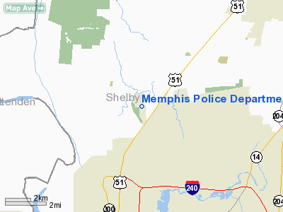
Memphis Police Department Heliport |
Location & QuickFacts
| FAA Information Effective: | 2008-09-25 |
| Airport Identifier: | 27TN |
| Airport Status: | Operational |
| Longitude/Latitude: | 090-00-57.0000W/35-14-58.0000N
-90.015833/35.249444 (Estimated) |
| Elevation: | 240 ft / 73.15 m (Estimated) |
| Land: | 5 acres |
| From nearest city: | 0 nautical miles N of Memphis, TN |
| Location: | Shelby County, TN |
| Magnetic Variation: | () |
Owner & Manager
| Ownership: | Privately owned |
| Owner: | City Of Memphis |
| Address: | 4517 O.k. Robertson Road
Membphis, TN 38127 |
| Phone number: | 901-354-5595 |
| Manager: | Lt. Mark Rewalt
SGT. CHARLIE VRSKA |
| Address: | 4517 O.k. Robertson Road
Memphis, TN 38127 |
| Phone number: | 901-354-5595 |
Airport Operations and Facilities
| Airport Use: | Private |
| Wind indicator: | Yes |
| Segmented Circle: | No |
| Control Tower: | No |
| Lighting Schedule: | DUSK-DAWN |
| Sectional chart: | Memphis |
| Region: | ASO - Southern |
| Boundary ARTCC: | ZME - Memphis |
| Tie-in FSS: | MKL - Jackson |
| FSS Toll Free: | 1-800-WX-BRIEF |
Airport Communications
Runway Information
Helipad HI
| Dimension: | 74 x 62 ft / 22.6 x 18.9 m |
| Surface: | CONC, |
| |
Runway HI |
Runway |
| Traffic Pattern: | Right | Left |
|
Radio Navigation Aids
| ID |
Type |
Name |
Ch |
Freq |
Var |
Dist |
| SPQ | NDB | Spain | | 414.00 | 04E | 3.4 nm |
| MIG | NDB | Millington | | 232.00 | 04E | 4.4 nm |
| ME | NDB | Elvis | | 287.00 | 01E | 11.6 nm |
| AWM | NDB | West Memphis | | 362.00 | 01E | 12.5 nm |
| OLV | NDB | Olive Branch | | 275.00 | 01E | 19.7 nm |
| BPW | NDB | Osceola | | 239.00 | 02E | 26.6 nm |
| COO | NDB | Covington | | 326.00 | 02E | 29.3 nm |
| FYE | NDB | Somerville | | 255.00 | 00E | 30.7 nm |
| MXA | NDB | Manila | | 282.00 | 01E | 39.2 nm |
| FCY | NDB | Forrest City | | 332.00 | 01E | 41.6 nm |
| IUI | NDB | Hicks | | 350.00 | 01E | 42.3 nm |
| BAV | NDB | Hardeman | | 404.00 | 01E | 47.9 nm |
| GOJ | VOR | Gosnell | | 111.80 | 01E | 42.3 nm |
| GQE | VOR/DME | Gilmore | 077X | 113.00 | 04E | 23.4 nm |
| JBR | VOR/DME | Jonesboro | 023X | 108.60 | 02E | 46.9 nm |
| MEM | VORTAC | Memphis | 122X | 117.50 | 01E | 14.2 nm |
| HLI | VORTAC | Holly Springs | 071X | 112.40 | 03E | 38.5 nm |
| MEM | VOT | Memphis Metropolitn | | 111.00 | | 12.1 nm |
Remarks
- PVDD VFR; PVT; APCH OPNS CONDUCTED FROM 110-165 DEGS; 175 TO 080 DEGS; DEP OPNS FROM 290-345 DEGS AND 355 TO 260 DEGS AREA IS MARKED.
Images and information placed above are from
http://www.airport-data.com/airport/27TN/
We thank them for the data!
|
|


