|
|
| McMinn County Airport |
 |
| IATA: MMI – ICAO: KMMI – FAA LID: MMI |
| Summary |
| Airport type |
Public |
| Owner |
McMinn County |
| Serves |
Athens, Tennessee |
| Elevation AMSL |
858 ft / 262 m |
| Coordinates |
35°23′50″N 084°33′45″W / 35.39722°N 84.5625°W / 35.39722; -84.5625 |
| Runways |
| Direction |
Length |
Surface |
| ft |
m |
| 2/20 |
6,450 |
1,966 |
Asphalt |
| Statistics (1998) |
| Aircraft operations |
30,000 |
| Based aircraft |
63 |
| Source: Federal Aviation Administration |
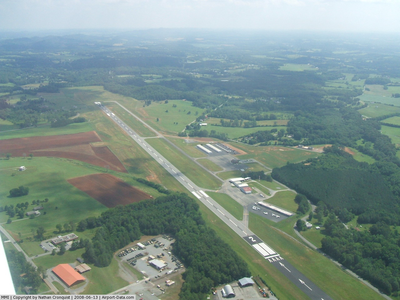
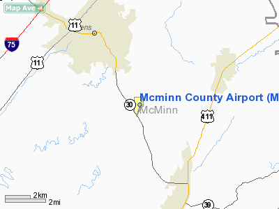
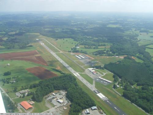
McMinn County Airport (IATA: MMI, ICAO: KMMI, FAA LID: MMI) is a county-owned, public-use airport located three nautical miles (6 km) southeast of the central business district of Athens, a city in McMinn County, Tennessee, United States. Facilities and aircraft
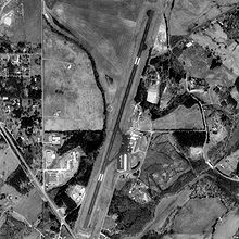
McMinn County Airport covers an area of 76 acres (31 ha) at an elevation of 858 feet (262 m) above mean sea level. It has one runway designated 2/20 with a 6,450 by 75 ft (1,966 x 23 m) asphalt surface.
For the 12-month period ending December 16, 1998, the airport had 30,000 aircraft operations, an average of 82 per day: 98% general aviation, 2% air taxi and <1% military. At that time there were 63 aircraft based at this airport: 95% single-engine, 3% multi-engine and 2% jet.
The Fixed base operator at McMinn County airport is Athens Air, LLC[1]
The airport is attended from 0830 to Dusk and has 100LL aviation fuel and Jet A. It is included under the Nashville FSS. It has medium intensity runway lighting, REIL on Runway 02, and VASI on both runways. NOTAMs are filed with Nashville International Airport.
The above content comes from Wikipedia and is published under free licenses – click here to read more.
 |
(Click on the photo to enlarge) |
Location & QuickFacts
| FAA Information Effective: | 2008-09-25 |
| Airport Identifier: | MMI |
| Airport Status: | Operational |
| Longitude/Latitude: | 084-33-45.2470W/35-23-50.2920N
-84.562569/35.397303 (Estimated) |
| Elevation: | 858 ft / 261.52 m (Surveyed) |
| Land: | 76 acres |
| From nearest city: | 3 nautical miles SE of Athens, TN |
| Location: | Mc Minn County, TN |
| Magnetic Variation: | 03W (1990) |
Owner & Manager
| Ownership: | Publicly owned |
| Owner: | Mcminn County |
| Address: | County Courthouse
Athens, TN 37303 |
| Phone number: | 423-745-7634 |
| Manager: | Bill Johnson |
| Address: | 195 County Road 552
Athens, TN 37303 |
| Phone number: | 423-745-4939 |
Airport Operations and Facilities
| Airport Use: | Open to public |
| Wind indicator: | Yes |
| Segmented Circle: | Yes |
| Control Tower: | No |
| Lighting Schedule: | DUSK-DAWN |
| Beacon Color: | Clear-Green (lighted land airport) |
| Landing fee charge: | No |
| Sectional chart: | Atlanta |
| Region: | ASO - Southern |
| Boundary ARTCC: | ZTL - Atlanta |
| Tie-in FSS: | BNA - Nashville |
| FSS on Airport: | No |
| FSS Toll Free: | 1-800-WX-BRIEF |
| NOTAMs Facility: | BNA (NOTAM-d service avaliable) |
| Federal Agreements: | NGY |
Airport Communications
| CTAF: | 122.800 |
| Unicom: | 122.800 |
Airport Services
| Fuel available: | 100LLA |
| Airframe Repair: | MAJOR |
| Power Plant Repair: | MAJOR |
Runway Information
Runway 02/20
| Dimension: | 6450 x 75 ft / 1966.0 x 22.9 m |
| Surface: | ASPH, Good Condition |
| Weight Limit: | Single wheel: 30000 lbs.
Dual wheel: 42000 lbs. |
| Edge Lights: | Medium |
| |
Runway 02 |
Runway 20 |
| Longitude: | 084-33-54.9340W | 084-33-29.9375W |
| Latitude: | 35-23-26.8760N | 35-24-27.2943N |
| Elevation: | 806.00 ft | 858.00 ft |
| Alignment: | 19 | 127 |
| Traffic Pattern: | Left | Left |
| Markings: | Non-precision instrument, Good Condition | Non-precision instrument, Good Condition |
| Displaced threshold: | 950.00 ft | 0.00 ft |
| VASI: | 2-box SAVASI on left side | 2-box SAVASI on left side |
| Runway End Identifier: | Yes | No |
| Obstruction: | 57 ft trees, 800.0 ft from runway, 278 ft left of centerline, 10:1 slope to clear | 73 ft trees, 1450.0 ft from runway, 172 ft left of centerline, 17:1 slope to clear
APCH SLOPE 23:1 TO DSPLCD THLD. |
|
Radio Navigation Aids
| ID |
Type |
Name |
Ch |
Freq |
Var |
Dist |
| MMI | NDB | Mc Minn County | | 242.00 | 03W | 0.2 nm |
| MNV | NDB | Madisonville | | 361.00 | 04W | 12.5 nm |
| DTE | NDB | Mark Anton | | 394.00 | 02W | 18.7 nm |
| HDI | NDB | Hardwick | | 369.00 | 01W | 22.3 nm |
| CQN | NDB | Daisy | | 341.00 | 02W | 32.3 nm |
| TTQ | NDB | Tomotla | | 335.00 | 01W | 34.2 nm |
| UWI | NDB | Whitfield | | 400.00 | 03W | 41.1 nm |
| HCH | VORTAC | Hinch Mountain | 123X | 117.60 | 02W | 30.7 nm |
| GQO | VORTAC | Choo Choo | 105X | 115.80 | 01E | 39.1 nm |
| HRS | VORTAC | Harris | 035X | 109.80 | 00E | 41.9 nm |
| VXV | VORTAC | Volunteer | 111X | 116.40 | 03W | 44.7 nm |
| TYS | VOT | Knoxville | | 112.00 | | 37.4 nm |
Remarks
- GCO AVBL ON FREQ 121.725 THRU FLIGHT SERVICES.
- TWY NORTH OF A5 CLSD.
- PAEW INVCNTY OF RY 02/20.
Images and information placed above are from
http://www.airport-data.com/airport/MMI/
We thank them for the data!
| General Info
|
| Country |
United States
|
| State |
TENNESSEE
|
| FAA ID |
MMI
|
| Latitude |
35-23-50.292N
|
| Longitude |
084-33-45.247W
|
| Elevation |
858 feet
|
| Near City |
ATHENS
|
We don't guarantee the information is fresh and accurate. The data may
be wrong or outdated.
For more up-to-date information please refer to other sources.
|
|