|
|
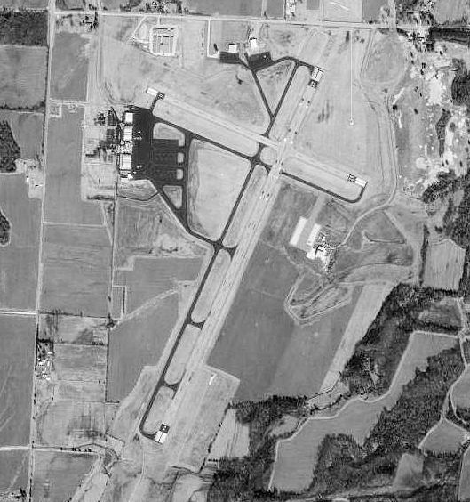
Mc Kellar-sipes Rgnl Airport |
| McKellar-Sipes Regional Airport |
 |
| USGS aerial image, 1 February 1997 |
| IATA: MKL – ICAO: KMKL – FAA LID: MKL |
| Summary |
| Airport type |
Public |
| Owner/Operator |
Jackson-Madison County Airport Authority |
| Serves |
Jackson, Tennessee |
| Location |
Madison County |
| Elevation AMSL |
434 ft / 132 m |
| Coordinates |
35°36′0″N 88°54′56″W / 35.6°N 88.91556°W / 35.6; -88.91556Coordinates: 35°36′0″N 88°54′56″W / 35.6°N 88.91556°W / 35.6; -88.91556 |
| Runways |
| Direction |
Length |
Surface |
| ft |
m |
| 2/20 |
6,006 |
1,831 |
Asphalt |
| 11/29 |
3,538 |
1,078 |
Asphalt |
| Statistics (2007) |
| Aircraft operations |
25,968 |
| Based aircraft |
48 |
| Source: Federal Aviation Administration |
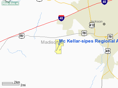
McKellar-Sipes Regional Airport (IATA: MKL, ICAO: KMKL, FAA LID: MKL) is a public use airport located four nautical miles (7 km) west of the central business district of Jackson, a city in Madison County, Tennessee, United States. It is owned by the City of Jackson & Madison County. The airport is mostly used for general aviation. TennesseeSkies provides scheduled service to the Nashville, Tennessee airport, beginning August 31, 2009.. History
The airport is also known as McKellar Field. It opened in 1942 and was assigned to the United States Army Air Forces Southeast Training Center (later the Eastern Flying Training Command) as a primary (level 1) pilot training airfield. There were also two local axillary airfields for emergency and overflow landings.
The airfield began training flying cadets under contract to Georgia Air Services, Inc. Flying training was performed with Fairchild PT-19s as the primary trainer. It also had several PT-17 Stearmans assigned.
The facility was inactivated on 16 October 1944 with the drawdown of AAFTC's pilot training program. It was declared surplus and turned over to the Army Corps of Engineers on 30 September 1945. Eventually it was discharged to the War Assets Administration (WAA) and became a civil airport.
McKellar-Sipes Regional Airport is named in memory of the late Kenneth Douglas McKellar (1869–1957), a U.S. senator from Tennessee; and Major Robert Ray Sipes, an Air Force pilot from Jackson who was killed in action during the Vietnam War in 1969. Sipes is buried at the Shiloh National Military Park cemetery.
Facilities and aircraft
McKellar-Sipes Regional Airport covers an area of 807 acres (327 ha) at an elevation of 434 feet (132 m) above mean sea level. It has two asphalt paved runways: 2/20 is 6,006 by 150 feet (1,831 x 46 m) and 11/29 is 3,538 by 100 feet (1,078 x 30 m).
For the 12-month period ending December 31, 2007, the airport had 25,968 aircraft operations, an average of 71 per day: 76% general aviation, 14% military, and 10% air taxi. At that time there were 48 aircraft based at this airport: 50% single-engine, 27% multi-engine, 2% jet, 4% helicopter and 17% military.
Airlines and destinations
| Airlines |
Destinations |
| TennesseeSkies operated by Pacific Wings |
Nashville |
The above content comes from Wikipedia and is published under free licenses – click here to read more.
Location & QuickFacts
| FAA Information Effective: | 2008-09-25 |
| Airport Identifier: | MKL |
| Airport Status: | Operational |
| Longitude/Latitude: | 088-54-56.2000W/35-35-59.6000N
-88.915611/35.599889 (Estimated) |
| Elevation: | 434 ft / 132.28 m (Surveyed) |
| Land: | 807 acres |
| From nearest city: | 4 nautical miles W of Jackson, TN |
| Location: | Madison County, TN |
| Magnetic Variation: | 02E (1980) |
Owner & Manager
| Ownership: | Publicly owned |
| Owner: | City Of Jackson & Madison Co
OPERATED BY JACKSON-MADISON COUNTY ARPT AUTHORITY. |
| Address: | City Hall
Jackson, TN 38301
MADISON COUNTY- COUNTY EXECUTIVE OFFICE, JACKSON, TN 38301. |
| Phone number: | 731-425-8241
MADISON COUNTY- 731-423-6020. |
| Manager: | Rodney Hendrix |
| Address: | 308 Grady Montgomery Dr
Jackson, TN 38301 |
| Phone number: | 731-423-0995 |
Airport Operations and Facilities
| Airport Use: | Open to public |
| Wind indicator: | Yes |
| Segmented Circle: | Yes |
| Control Tower: | Yes |
| Lighting Schedule: | DUSK-DAWN
WHEN ATCT CLSD ACTVT HIRL RY 02/20, MIRL RY 11/29 & MALSR RY 02 - CTAF. |
| Beacon Color: | Clear-Green (lighted land airport) |
| Landing fee charge: | No |
| Sectional chart: | Memphis |
| Region: | ASO - Southern |
| Boundary ARTCC: | ZME - Memphis |
| Tie-in FSS: | MKL - Jackson |
| FSS on Airport: | No |
| FSS Toll Free: | 1-800-WX-BRIEF |
| NOTAMs Facility: | MKL (NOTAM-d service avaliable) |
| Certification type/date: | I A S 04/1989
CLSD TO UNSKED ACR OPNS WITH MORE THAN 30 PSGR SEATS EXCP 24 HRS PPR CALL AMGR 731-423-0995. |
| Federal Agreements: | NGRY3 |
Airport Communications
| CTAF: | 127.150 |
| Unicom: | 122.950 |
Airport Services
| Fuel available: | 100LLA |
| Airframe Repair: | MAJOR |
| Power Plant Repair: | MAJOR |
| Bottled Oxygen: | NONE |
| Bulk Oxygen: | NONE |
Runway Information
Runway 02/20
| Dimension: | 6006 x 150 ft / 1830.6 x 45.7 m |
| Surface: | ASPH, Fair Condition |
| Surface Treatment: | Saw-cut or plastic Grooved
02/20 GROOVED 55 FT EACH SIDE OF CNTRLN. |
| Weight Limit: | Single wheel: 55000 lbs.
Dual wheel: 80000 lbs.
Dual tandem wheel: 125000 lbs. |
| Edge Lights: | High |
| |
Runway 02 |
Runway 20 |
| Longitude: | 088-55-10.9760W | 088-54-43.4570W |
| Latitude: | 35-35-25.6376N | 35-36-20.6211N |
| Elevation: | 434.00 ft | 411.00 ft |
| Alignment: | 22 | 127 |
| ILS Type: | ILS
| |
| Traffic Pattern: | Left | Left |
| Markings: | Precision instrument, Good Condition | Precision instrument, Good Condition |
| VASI: | 4-light PAPI on left side
RY 02 PAPI NOT COINCIDENTAL WITH I-MKL GLIDE SLOPE PATH. | 4-light PAPI on left side |
| Approach lights: | MALSR | |
| Runway End Identifier: | | Yes |
| Obstruction: | , 50:1 slope to clear | 40 ft tree, 1400.0 ft from runway, 600 ft right of centerline, 30:1 slope to clear |
|
Runway 11/29
| Dimension: | 3538 x 100 ft / 1078.4 x 30.5 m |
| Surface: | ASPH, Fair Condition |
| Weight Limit: | Single wheel: 27000 lbs. |
| Edge Lights: | Medium |
| |
Runway 11 |
Runway 29 |
| Longitude: | 088-55-14.3176W | 088-54-34.6757W |
| Latitude: | 35-36-17.1184N | 35-36-03.8511N |
| Elevation: | 407.00 ft | 416.00 ft |
| Alignment: | 112 | 127 |
| Traffic Pattern: | Left | Left |
| Markings: | Basic, Good Condition | Basic, Good Condition |
| VASI: | 4-light PAPI on left side | 4-light PAPI on left side |
| Obstruction: | 66 ft tree, 1650.0 ft from runway, 50 ft right of centerline, 21:1 slope to clear | 45 ft tree, 1100.0 ft from runway, 320 ft left of centerline, 20:1 slope to clear |
|
Radio Navigation Aids
| ID |
Type |
Name |
Ch |
Freq |
Var |
Dist |
| TGC | NDB | Gibson | | 378.00 | 01E | 20.3 nm |
| BAV | NDB | Hardeman | | 404.00 | 01E | 24.0 nm |
| SZY | NDB | Sibley | | 386.00 | 01E | 29.3 nm |
| COO | NDB | Covington | | 326.00 | 02E | 32.8 nm |
| FYE | NDB | Somerville | | 255.00 | 00E | 33.3 nm |
| DNT | NDB | Nally Dunston | | 343.00 | 01W | 33.7 nm |
| HZD | NDB | Huntingdon | | 217.00 | 00E | 36.6 nm |
| HHY | NDB | Pinhook | | 346.00 | 01W | 40.6 nm |
| UC | NDB | Obion | | 212.00 | 00E | 42.1 nm |
| TIQ | NDB | Trainer | | 410.00 | 00E | 46.0 nm |
| IUI | NDB | Hicks | | 350.00 | 01E | 49.2 nm |
| MKL | VOR/DME | Mc Kellar | 057X | 112.00 | 02E | 0.3 nm |
| JKS | VOR/DME | Jacks Creek | 031X | 109.40 | 02E | 27.2 nm |
| DYR | VORTAC | Dyersburg | 115X | 116.80 | 03E | 31.9 nm |
Remarks
- NG BASE OPS OPER 0630-1600 MON-FRI. PPR C731-426-0584/0581.
- PPR FOR GROUND ACCESS TO FIELD 2130-0600, CALL 731-423-0995.
- ACR OPNS INVOLVING AIRCRAFT WITH MORE THAN 9 PSGR SEATS ARE NOT AUTHORIZED IN EXCESS OF 15 MINUTES BEFORE OR AFTER SCHEDULED ARR OR DEP TIMES W/O PRIOR COORDINATION WITH ARPT MNGMT AND CONFIRMATION THAT ARFF SERVICES ARE AVAILABLE PRIOR TO LNDG OR TKOF.
Images and information placed above are from
http://www.airport-data.com/airport/MKL/
We thank them for the data!
| General Info
|
| Country |
United States
|
| State |
TENNESSEE
|
| FAA ID |
MKL
|
| Latitude |
35-35-59.566N
|
| Longitude |
088-54-56.218W
|
| Elevation |
434 feet
|
| Near City |
JACKSON
|
We don't guarantee the information is fresh and accurate. The data may
be wrong or outdated.
For more up-to-date information please refer to other sources.
|
|